Another round of thunderstorms, containing damaging winds, heavy rain, and frequent lightning, will move through central Mississippi this morning. Strong to locally severe thunderstorms will be a threat for the rest of the week. Temperatures will remain quite muggy, especially in the Pine Belt and along the Gulf Coast. Humidity will make the “feels like” temperature to be near 100, even as actual temperature may not exceed 90.
Wheel in the Sky
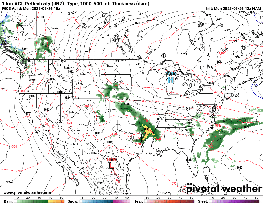
A blocking pattern, similar to a “rex block” involving low pressure underneath a high pressure, is currently situated to the west of the forecast area. Ridging is apparent in the Midwest, while low pressure is present in Texas and Oklahoma. A stationary front exists to our north, allowing the low pressures to sit in place and funnel Gulf moisture into the area, which, combined with ample instability, creates a pattern in which multiple rounds of thunderstorms will be able to form. Stationary fronts can also cause rain themselves as air masses converge.
This will create a, for lack of a better term, annoying weather pattern, in which it can be partly cloudy when school is dismissed, only for it to be pouring rain by dinner time. Have back up plans if you have any outdoor activities scheduled this week.
Thunderstorm Details

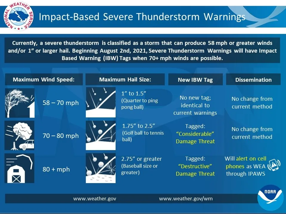
Soundings and models alike are showing some pretty healthy CAPE (or instability in layman’s terms). The Storm Prediction Center does not have a hatched wind risk yet, but severe thunderstorm warnings (perhaps with “considerable” or “destructive” tags due to 70 or 80 mile per hour winds respectively) can’t be ruled out, mainly in the northern part of the forecast area. When thunder roars, get indoors, and if winds get that intense, maybe move away from windows and spend time in the interior of your home.
With any setup like this with multiple rounds of heavy rain, especially near the stationary front that will be present in central and/or northern Mississippi, is localized flooding. Any area subject to multiple inches of rain for consecutive days will be at risk. Most models have portions of the forecast area receiving 4″ of rain or more in the next few days, although exact values will vary locally. If you live in a flood prone area, like in an urban area or near a body of water, make sure you have access to weather warnings and a place to go if flooding occurs.
The further south within the forecast, the more conditional in nature the threat becomes. For locales like Biloxi and Sidell, the lifting mechanisms might not be in place for a severe threat to materialize. A lot depends on the precise positioning of the stationary front and low pressure, as well as the angle of the shortwaves that will induce these storms. The threat increases as you get into the Pine Belt, and increases further from there.
Wind shear appears to not be too impressive, so tornado potential appears to be low, but can never be ruled out on the intersection of colliding outflow boundaries in thunderstorm clusters. The scattered and linear nature of these storms means that it’s unlikely one individual storm would get powerful enough to produce large hail. There is enough instability to make smaller hail a possibility, maybe up to an inch in diameter.
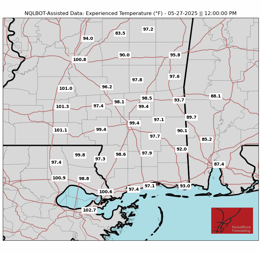
All this moisture will make things feel very steamy, with the apparent temperature reaching 100 in areas to the west that get done with thunderstorms a bit earlier and the sun has more time to shine. Similar temperatures are expected the rest of the work week. If you’re outdoors, drink plenty of water and take frequent breaks.
When Do We Break Free?
A regime of high pressure looks to assert itself, advecting drier conditions, just in time for the weekend. Isobars will be far apart from each other, so there will be little wind. High temperatures will remain in the 80s.
Looking into the work week next week, we should start with average conditions. Later in the work week, we will once again expect wetter and warmer conditions, as a mid-level trough could transport moisture from a tropical system near the Pacific coast of Mexico.
REGIONAL DAY TO DAY FORECAST
Today: Line of showers with isolated thunderstorms in the morning, partly sunny this afternoon. Some thunderstorms may be severe. Highs in the upper 80s. Southwest winds 5 to 10 mph. Chance of rain 90 percent.
Tonight: Mostly cloudy with numerous showers. Lows in the upper 60s. South winds around 5 mph in the evening, becoming light and variable. Chance of rain 50 percent.
Wednesday: Scattered thunderstorms. Highs in the upper 80s. Chance of rain 80 percent.
Thursday: Fog possible in the morning. Showers and scattered thunderstorms. Highs in the mid 80s. Chance of rain 70 percent.
Friday: Numerous showers and scattered thunderstorms. Highs in the lower 80s. Chance of rain 60 percent.
Saturday: Mostly clear. Highs in the mid 80s.
Sunday: Partly cloudy. Highs in the high 80s.
Monday: Partly cloudy. Highs in the high 80s.
Tuesday: Mostly cloudy. Highs in the high 80s. Chance of rain 30 percent.
Wednesday: Scattered showers and thunderstorms. Highs in the low 90s. Chance of rain 50 percent.
Thursday: Scattered showers and thunderstorms. Highs in the low 90s. Chance of rain 60 percent.


