Storms will persist throughout today, Thursday, and Friday, so be prepared for rain and thunderstorms until the end of the week. Although it might seem like there’s no end to this stormy and wet weather, there should be a bit of a break during the weekend with some sunny skies. Next week will bring with some fair weather in the morning with possible storms in the afternoons. Temperature-wise, high temperature will tend to be in the 80s on Wednesday, and will be mostly unchanged for the rest of this week and going into next week.
The Current Situation
There are a few more days of stormy weather to get through, so here’s what’s going on:
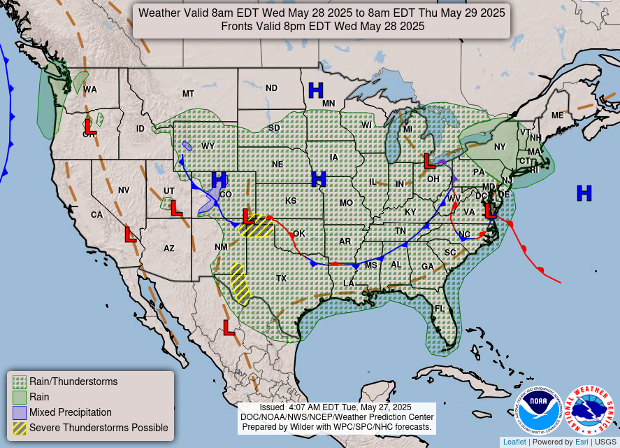
As seen in the image above, there is a stationary front over Louisiana and Mississippi encouraging stormy activity in the area. Therefore, we see rain and thunderstorms forecasted for much of the continental United States. There is also a trough (the brown dotted line) located along the coast of Texas, Louisiana, Mississippi, and Alabama. This trough indicates an area of low pressure, also contributing to the soggy weather we are experiencing.
Additionally, the CAPE Index is currently quite high and will stay high throughout the week. The higher the CAPE, the greater chance of severe weather, such as thunderstorms, occurring. So, keep an eye out for any thunderstorms in your area, so you can get indoors when needed.
Temperature-wise, high temperatures will sit around the 80s for the week and continue into next week. Low temperatures will also stay pretty constant in the low 70s this week and next week. Relative humidity will be somewhat high, so it may feel a bit hotter outside than it actually is, so make sure to stay hydrated if you’re going to take advantage of the sunny weekend with outdoor activities!
Concerns
Risks for severe weather are persisting throughout today and tomorrow, so let’s take a look at a couple different regions:
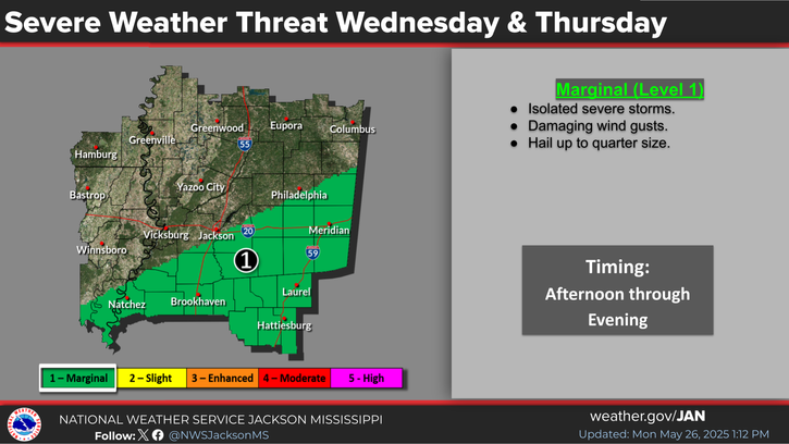
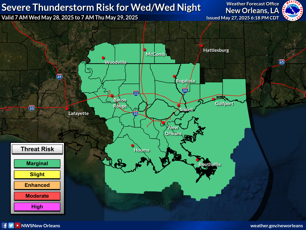
As seen in the two images above, there is a level 1 risk for severe weather such as thunderstorms, strong wind, and even hail. Although these risks are marginal, they should not be ruled out, and proper safety precautions should be taken, especially since lighting is possible as well. Putting a pause on outdoor activities and staying inside when possible is a good idea for now.
Moving Into Next Week
After the wet weather for the rest of the week, we can expect some fairly nice weather for the weekend. Starting Friday afternoon, we should see some clear skies that will last until a possible thunderstorm on Sunday afternoon. Temperatures will be in the high 80s for the weekend, and a somewhat high relative humidity, so just keep that in mind for an outdoor plans this weekend.
Going into next week, we will see pattern of nice and sunny conditions, but with a slight chance of precipitation or storms, making outdoor planning a bit tricky. High and low temperatures will stay around the same as the weekend .
Regional Day-To-Day Forecast:
Today: Showers throughout the morning, with a chance of thunderstorms in the afternoon. Highs in upper 80s. Chance of rain 60%.
Tonight: Showers and thunderstorms scattered throughout the evening. Lows in the low 70s. Chance of rain 50%.
Thursday: Showers and thunderstorms likely throughout the day. Highs in the mid 80s during the day and lows in the low 70s at night. Chance of rain 80%.
Friday: Showers and Thunderstorms in the morning, but should clear up later in the afternoon. Highs in the mid 80s during the day and lows in the mid 60s at night. Chance of rain 50%
Saturday: Sunny skies and highs in the mid 80s. Lows in the mid 60s at night. Winds will be calm.
Sunday: Mostly sunny with a possible thunderstorm in the afternoon. Highs in the high 80s during the day and lows in the upper 60s at night.
Monday: Mostly sunny and a small chance of showers and thunderstorms. Highs in the high 80s during the day, with lows in the low 70s at night.
Tuesday: Mostly sunny with a small chance of showers and even a possibly thunderstorm. Highs in the high 80s and lows in the low 70s at night.


