The National Hurricane Center has officially, as predicted by yesterday’s forecast by Matthew, given the name of Alvin to the disturbance we’ve been following south of Mexico, meaning it’s become organized and has sustained winds at the center above 39 miles per hour.
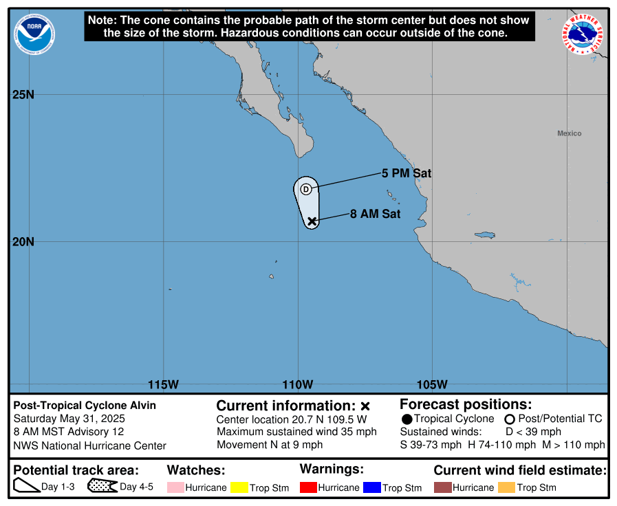
At present, Tropical Storm Alvin has maximum sustained winds of 40 mph, with gusts up to 50 mph, and has a minimum central pressure of 1005 mb. It is located 650 miles south-southeast of Cabo San Lucas, or 375 miles southwest of Manzanillo, moving northwest at 10 miles per hour. It may be a good deal closer to Cabo San Lucas by the time you read this, however.
Some outer bands have made their way into the Mexican states of Colima, Jalisco, and Michoacan. While flooding is not expected, conditions may allow for a tornado or two to form in these areas. Down the road, the storm may have impacts in Baja California, and moisture from the storm could make things wet in the southwestern United States.
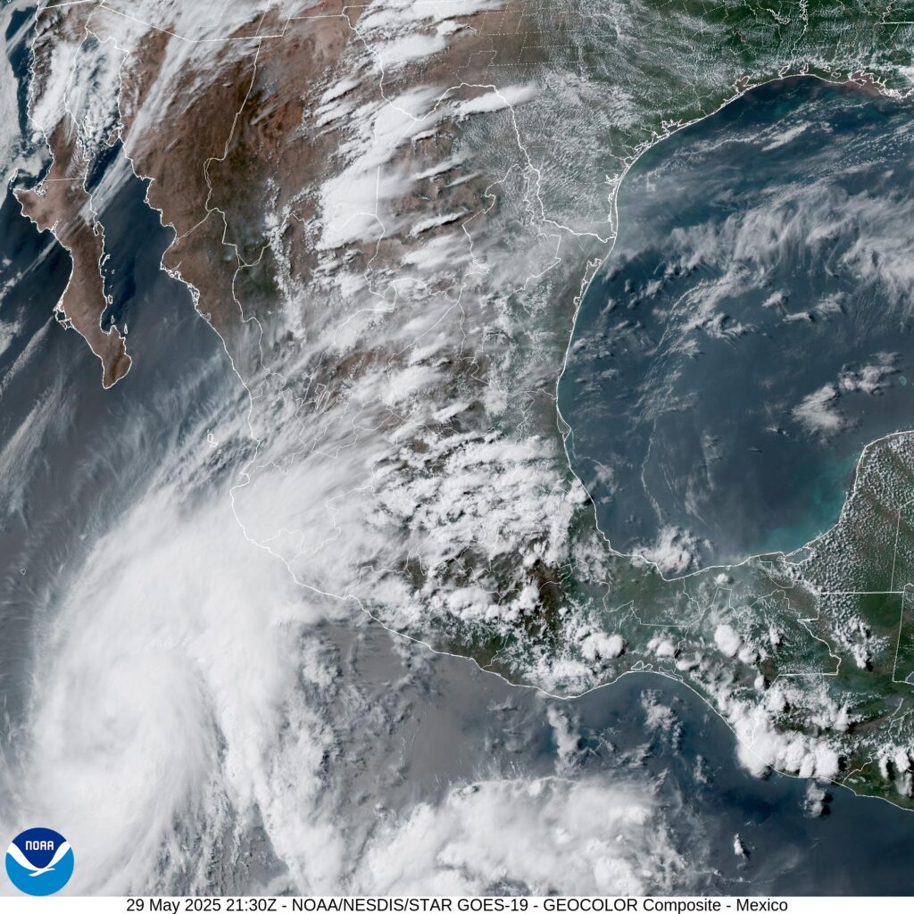
Some outer bands of rain have made their way into the Mexican states of Colima, Jalisco, and Michoacan. Flooding and surge is not expected, the storm isn’t intense enough to generate massive rainfall totals too far from the circulation center, and the wind is blowing offshore so surge isn’t likely to form at this point.
Conditions may allow for a tornado or two to form in these areas. Tornadoes are prone to form in the northeast quadrant of a hurricane, and atmospheric instability and low-level shear are sufficient for tornadic development, although the mountainous topography of the region is more likely to inhibit tornado formation than aid in it.
Down the road, the storm may have impacts in northwestern Mexico Saturday night into Monday, mainly rain, wind, and perhaps a little storm surge. Thankfully the storm is expected to weaken and become less organized, as it will encounter an area of higher wind shear, higher atmospheric stability, and ocean water that isn’t quite as warm. There’s a bit of a disagreement between the traditional models, that steer the storm towards Baja California Sur head on, and the newer AI models, which have the storm a bit further to the east, impacting Sonora or Sinaloa instead.
This is really the first hurricane season where the newer AI models have a stronger foothold. But it always important to remember that the “strengths” or “weaknesses” of these models are different across each model.
Regardless, anyone with maritime interests in northwestern Mexico, or anyone planning summer vacations to Cabo this weekend or early next week, should keep their eyes on this storm, and potential travel delays associated with it. The NHC is predicting this system will weaken beneath Tropical Storm status by Sunday, and given the fundamentals, I don’t disagree with them.

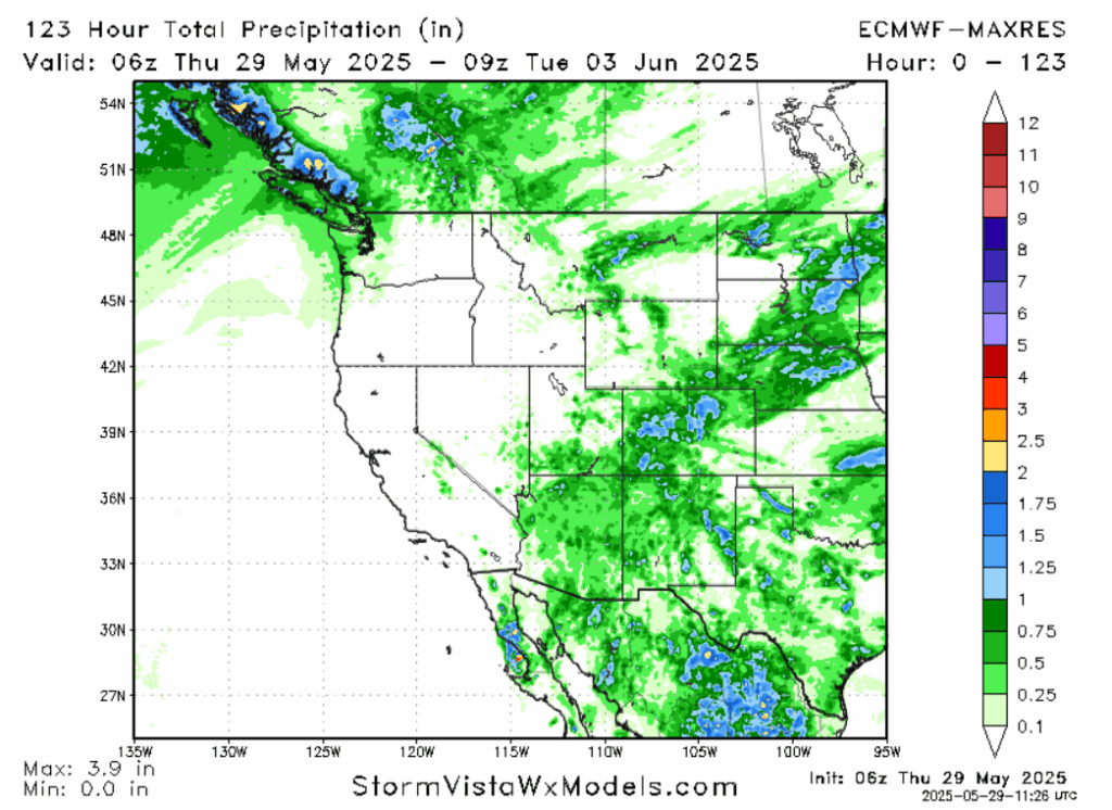
It is expected that moisture from this storm will bring rain to the Four Corners region of the United States, with Colorado being the state most likely to receive multiple inches of rain on the aggregate. But even an inch of rain is a lot for this part of the country in the dry season, where many areas would be lucky to receive an inch of rain the whole month of May. The rain will set in early in the work week next week. Flash flooding will be possible in mountainous areas.
As for any potential future tropical cyclones, some ensemble members are showing activity in the Gulf of Mexico in the 1-2 week time frame. Ocean waters are certainly warm enough to support tropical development, but wind shear and Saharan dust may pose an issue for any storm that tries to form. Conditions may also be favorable for another system to form in the same area that gave rise to Alvin, as shear will remain low and water will remain warm.
So if you’re in Northwestern Mexico or the Four Corners area of the United States, things may get wet and windy this weekend into the next work week. But the storm shouldn’t be strong enough by that time to cause much more harm than that, save a tornado or two. Stay tuned to Nickelblock Forecasting and local media for more details and updates as they become available.


