While summer technically doesn’t start for another 17 days, us meteorologists have coined a term called “meteorological summer”, which if you ask me is a lot easier to keep track of. Meteorological summer is merely the months of June, July, and August. Therefore, it’s no surprise that a summer-like weather pattern is setting up across our area.
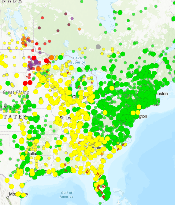
Sandwiched between a ridge to the west and a high pressure to our east, the ambient weather conditions are expected to be clear this week. That is, unless the Canadian wildfire smoke is rotated in. The forecast area is too far south to get the apocalypse-like scenes, for example, in upstate New York in 2023 or San Francisco in 2020, but there’s a chance a light haze may overspread the sky a day or two this week.
If you’re a part of a sensitive group, such as the elderly or those with respiratory illness, be sure to monitor the Air Quality. If it approaches or exceeds 100 ug/m^3, as it is currently in parts of Tennessee and South Carolina, be sure to limit outdoor activity.
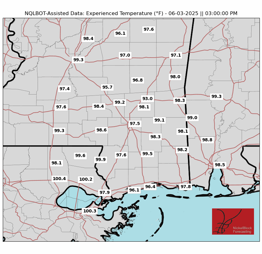
Temperatures will flirt with or surpass 90 degrees every day, and as a more moist air mass moves in this week, apparent temperatures may reach the triple digits. Surprisingly, if there is wildfire smoke, that would actually decrease the temperature on the ground, as the smoke would absorb some of the incoming solar radiation.
THUNDER POSSIBLE
This moisture will also raise the risk for thunderstorms. While the atmosphere will likely be too stable for supercells or severe weather, some “garden variety thunderstorms” are possible anywhere a lifting mechanism such as a shortwave can cause a thunderstorm to form. When thunder roars, go indoors, and stay inside for at least 30 minutes after the last lightning strike.
If there is Canadian wildfire smoke above us, that could actually inhibit storm formation. In much the same way cloud cover early in the morning can inhibit severe weather later in the day, preventing the upper atmosphere from becoming unstable, smoke can have a similar upset. And if a thunderstorm does form, the smoke particles themselves can act as cloud condensation nuclei (CCN). All raindrops form around CCN, but smoke particles are not very large or efficient as CCN, resulting in weaker storms.
Nevertheless, the Storm Prediction Center has issued a “General Thunderstorm Risk” for areas closer to the Gulf coast, likely due to higher humidity in those areas. On Day 3 as more moisture arrives, this risk is expanded to include the entire forecast area. It will be the kind of setup that will get certain folks to complain after a thunderstorm hits that “my weather app said it was only a 24% chance of rain”. The best chances for thunderstorms on a given day will be in the late afternoon and early evening, as the dew point and temperature get closer to each other.
EXTENDED OUTLOOK
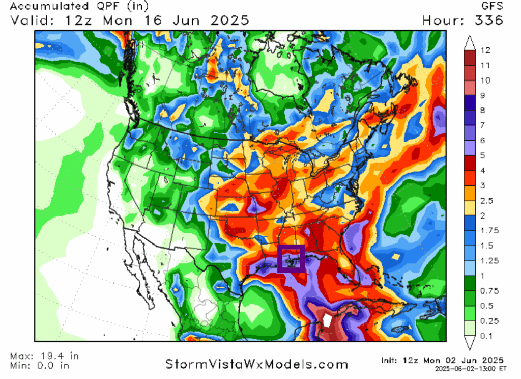
This pattern of above average temperatures and precipitation is expected to continue next week. Lots of frontal activity is expected in the eastern United States, which in addition to advecting moisture from land, will help unlock the Gulf moisture. The GFS model is particularly bullish on rain, calling for 5-6 inches, with heavier amounts south, across the forecast area. On days without rain, you’d be more likely to make money betting on higher than normal temperatures, as the current ridge on the West Coast moves into the area. Wind also seems to not be a factor, especially in inland areas, unless a front or storm rolls through.
AN EYE ON THE TROPICS
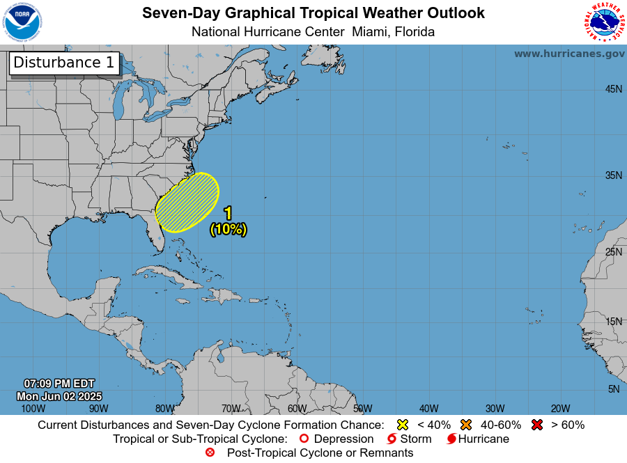
The National Hurricane Center has highlighted an area off the coast of Georgia and South Carolina with a 10% chance of tropical development in the next 3-7 days. I agree that it’s a farfetched scenario that anything gets going, due to wind shear, meager moisture, and questionably upper-air dynamics. If something were to form, it would likely due so this weekend when shear is lower. If anything were to form, it would likely not hit land, going nearly due east into the Atlantic, maybe impacting Bermuda down the line, but nothing else.
DAY-BY-DAY OUTLOOK
Today: Mostly sunny. Highs around 90. Chance of rain 20%.
Tonight: Clear. Lows around 70.
Tomorrow: Mostly sunny. Highs in the upper 80s. Chance of an afternoon thunderstorm. Haze possible. Chance of rain 50%. Lows around 70.
Thursday: Mostly sunny. Highs in the upper 80s. Chance of an afternoon thunderstorm. Haze possible. Chance of rain 40%. Lows in the lower 70s.
Friday: Partly cloudy. Highs in the lower 90s. Chance of an afternoon thunderstorm. Chance of rain 30%. Lows in the lower 70s.
Saturday: Partly cloudy. Highs in the lower 90s. Chance of an afternoon thunderstorm. Chance of rain 40%. Lows in the lower 70s.
Sunday: Mostly cloudy. Highs in the lower 90s. Chance of an afternoon thunderstorm. Chance of rain 40%. Lows around 70.
Monday: Partly cloudy. Highs around 90. Lows in the upper 60s.
Tuesday: Partly cloudy. Highs in the lower 90s. Lows around 70.
Wednesday: Partly cloudy. Highs in the mid 90s. Chance of rain 30%. Lows in the upper 70s.
Thursday: Rain. Highs in the mid 90s. Chance of rain 70%. Lows in the mid 70s.


