Meteorological summer is here and we’re already starting to see some typical summer weather. As for this week and then going into next week, we’ll be seeing a pattern of sunny mornings and stormy afternoons. Temperatures and humidity will both be on the rise, so its going to get muggy and hot. Let’s take a closer look at what’s going on:
Outlook for the rest of this week:
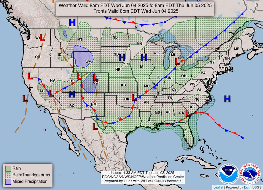
Today we’ll being seeing some showers and possible thunderstorms throughout the region. Our area is sitting between two low pressure systems associated with two stationary fronts. The low pressure system over Oklahoma has been moving in towards us and unfortunately will bring some soggy weather our way. The stationary fronts surrounding us will lock in the rainy weather for the day.
For the rest of the week, it’s going to feel a lot like typical summer weather. We’ll be seeing the pattern of beautiful and sunny during the morning and then storms popping up later in the afternoon. Temperatures will reach the upper 80s during the day, with high relative humidity making it feel a little muggy.
Along with these afternoon and evening showers and thunderstorms, there is a potential for severe weather to occur, such as lightning and hail. Take a look at the image below: Although the risk for severe weather is only marginal or slight, it is still something to keep an eye on. These storms tend to pop up across different areas, so be sure to watch for any warnings for severe weather, and it’s not a bad idea to look at the radar before going outside.

Repeated rainfall over multiple days may pose a threat of flash flooding, especially for much of Alabama and areas along the Mississippi River. The National Weather Service office in Jackson has already put out an advisory for these potential floods. So, if you are in the area keep an eye out for any more flood advisories, and if you encounter a flooded road while driving make sure to turn around find an alternative route.
Outlook for the weekend: Summery Temperatures are here!
As for this weekend, we’ll be seeing a similar pattern of sunny mornings and stormy afternoons. Going into next week, the beginning of the week is looking like more wet weather.
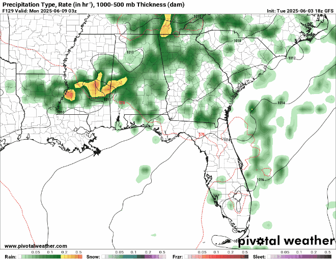
In the precipitation forecast above for next week, we can see scattered showers throughout the area for Monday, Tuesday, and Wednesday, and then clearing out for the most part by Thursday. Once again, if you plan on being outside, take a look at the radar or any warnings to avoid getting soaked in a pop up shower.

Temperatures are also going to get pretty hot, with high temperatures exceeding 90 degrees for both Saturday and Sunday. Check out the experienced temperatures above for Saturday morning, its going to feel like well over 100 degrees. So, if your planning outdoor activities in the morning to beat the afternoon rain and thunderstorms, definitely stay hydrated and keep cool!
Regional Day-to-Day Forecast:
Today: Showers and thunderstorms likely. Highs in the high 80s. Chance of precipitation 50%.
Tonight: Chance of showers and thunderstorms early on in the night and will clear up later. Lows in the low 70s. Chance of precipitation 20%.
Thursday: Partly sunny in the morning and a chance of showers and thunderstorms in the afternoon. Highs in the high 80s during the day and lows in the mid 70s at night. Chance of precipitation 40%.
Friday: Mostly sunny in the morning and a chance of showers and thunderstorms in the afternoon. Highs in the low 90s during the day and lows in the mid 70s at night. Chance of precipitation 40%.
Saturday: Mostly sunny in the morning and a chance of showers and thunderstorms in the afternoon. Highs in the low 90s during the day and lows in the mid 70s at night. Chance of precipitation 50%.
Sunday: Mostly cloudy in the morning and a chance of showers and thunderstorms in the afternoon. Highs in the low 90s during the day and lows in the low 70s at night. Chance of precipitation 70%.
Monday: Showers and thunderstorms likely. Highs in the high 80s during the day and lows in the mid 70s at night. Chance of precipitation 60%.
Tuesday: Showers and thunderstorms likely. Highs in the high 80s during the day and lows in the low 70s at night. Chance of precipitation 50%.


The ‘time-lapse’ video is hard to use if there is no way to stop and start it. Almost impossible to look at the time AND what’s going on with the map too.