Hello everyone! There is currently two tropical disturbances going on, one south of Mexico in the East Pacific, and another in the Atlantic making its way up Georgia and the Carolinas. Now we can see that Atlantic hurricane season is definitely here! Let’s take a look at the details of each disturbance and see what might be happening with them in the following days.
The Atlantic Disturbance
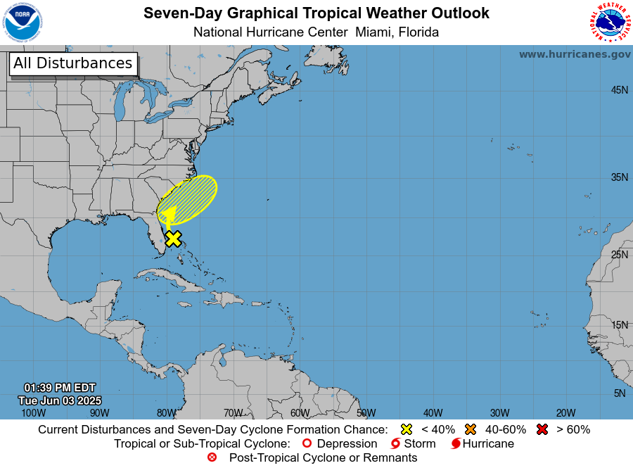
As you can see in the yellow region, this disturbance is creeping up the coast of Florida, Georgia, and the Carolinas. This disturbance only has a 10% chance of forming in the next week, as environmental conditions aren’t looking too great for tropical activity. In addition to this, there is not yet a strong area of low pressure for the storm to center itself on, and is forecast to move offshore and further into the Atlantic in the next few days.
For one, sea surface temperatures in the area are just barely warm enough to sustain tropical storms. CAPE, a measure of atmospheric instability, isn’t looking quite high enough to really push the potential for a tropical storm until Thursday. As far as wind shear goes, it will stay high until Thursday and then pick back up again on Saturday, leaving a small window of time for this disturbance to form into something concerning.
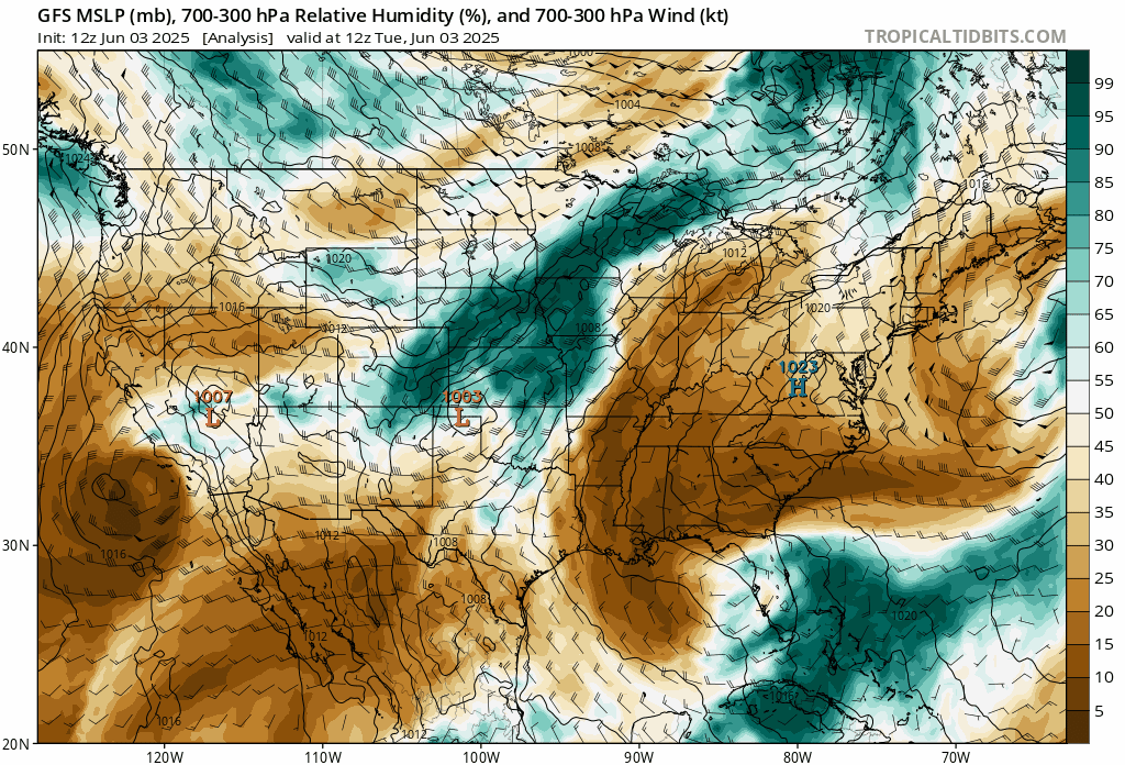
As you can see in the model below, there are only short windows of time throughout the rest of the week where humidity will be high in the area. High relative humidity at these levels are needed to feed tropical storms.
So overall, all signs seem to point to this disturbance not having much of a chance to form into a tropical storm. Many different conditions would have to align during a short time period, around Thursday and Friday, for the disturbance to be able to progress.
The Pacific Disturbance
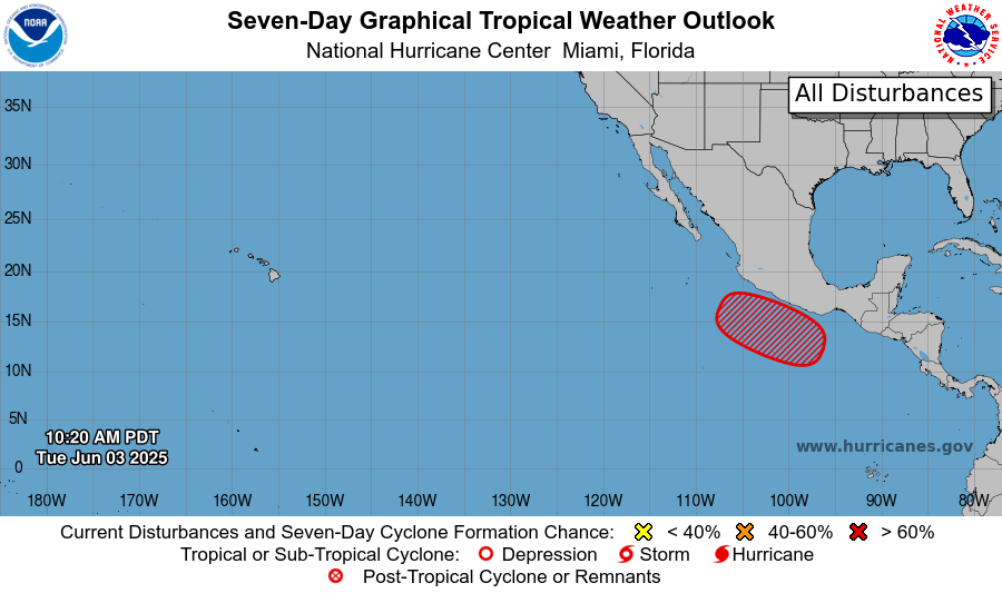
The National Hurricane center has raised the chance of this disturbance becoming a tropical cyclone in the next 7 days from 40% yesterday to 70% today. This disturbance has a very similar setup to what we saw last week with Tropical Storm Alvin, with a disturbance sitting right below the southern coast of Mexico moving northwestward at around 10 mph.
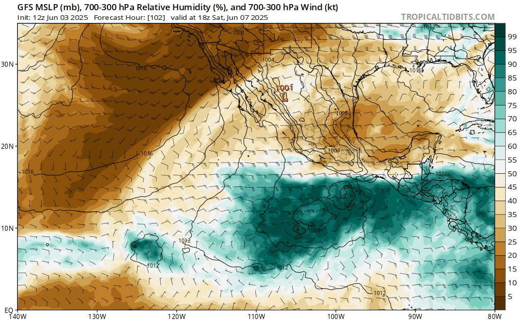
Check out the model of relative humidity below: we can see the low pressure center and area of very high humidity move west-northwestward and then dissipate off into the Pacific by Wednesday. Also note that this isn’t forecasted to occur until early next week, around Monday, so it may take a while for this disturbance to really organize.
Unlike what’s going on in the Atlantic, sea surface temps south of Mexico are currently around 86 degrees, and are forecasted to stay about the same for the rest of the week. These scorching ocean temperatures are definitely high enough to help encourage the formation of this disturbance. Vertical wind shear is pretty low in the area, but may have some spots of shear picking up throughout the week, which may affect the disturbance’s development.
Looking Ahead
While conditions in the Atlantic are looking pretty unfavorable for tropical activity, the Pacific, specifically south of Mexico, seems to be the hotspot for tropical disturbances. Additionally, the atmospheric conditions are still looking good for more potential activity there, so we will keep an eye on that for any more action in that area and throughout the tropics.
So for now, these two disturbances aren’t looking like anything too concerning, but we can definitely see that Atlantic hurricane season is coming in hot, so get ready and stay tuned for more tropical updates from NickelBlock!


