We thought two disturbances in the eastern Pacific was a big deal but come along to today and we have a third one listed by the National Hurricane Center (NHC). All the while the Atlantic waits calmly while the Pacific has its time to shine. We are looking at 3 disturbances in the eastern Pacific, one of which has a high chance of developing within the next 48 hours. There’s plenty to talk about in the tropics today so let’s dive into it!
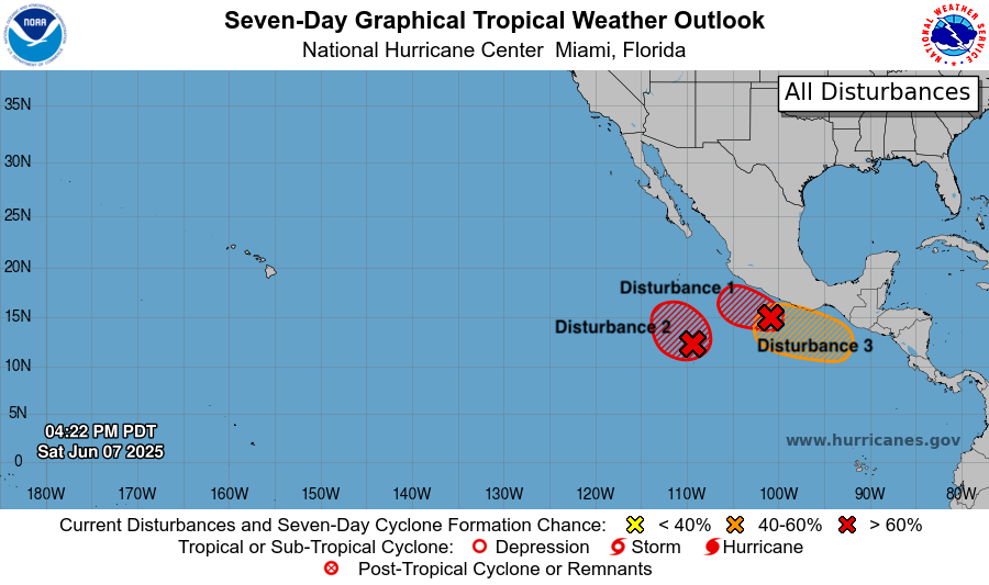
Eastern Pacific Disturbance 1
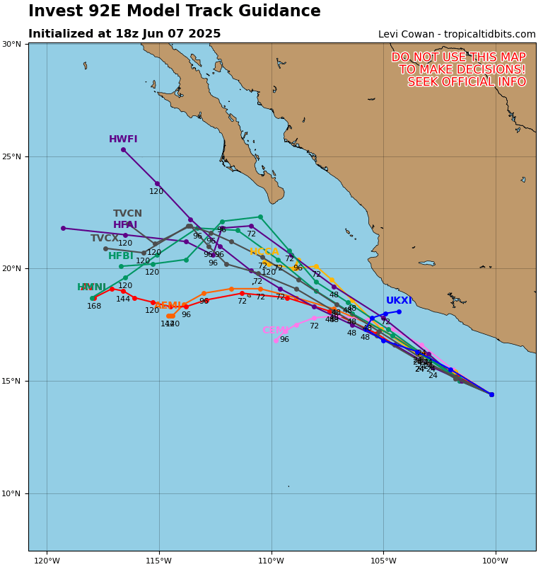
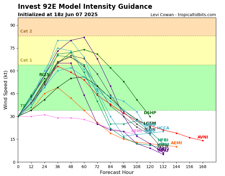
Disturbance 1, also known as Invest 92E (EP92), is developing into what will likely be a tropical cyclone within the next 48 hours. According to the NHC this invest has a 90% chance of tropical cyclone development within the next 48 hours and through the next 7 days also a 90% chance of formation. Invest 92E is current moving off the southern coast of Mexico and is expected to move west-northwest over the next few days. It is about 150 miles south of the Mexican coast. Right now this disturbance has a low pressure of 1004-mb and expected to drop more. Heavy rainfall and strong to gale force winds are expected off the coast of Mexico which can lead to flash flooding and damage from winds. This storm is expected in increase in intensity with some models predicting it to reach hurricane status within the coming days. This system is definitely something to be on the lookout for!
Eastern Pacific Disturbance 2
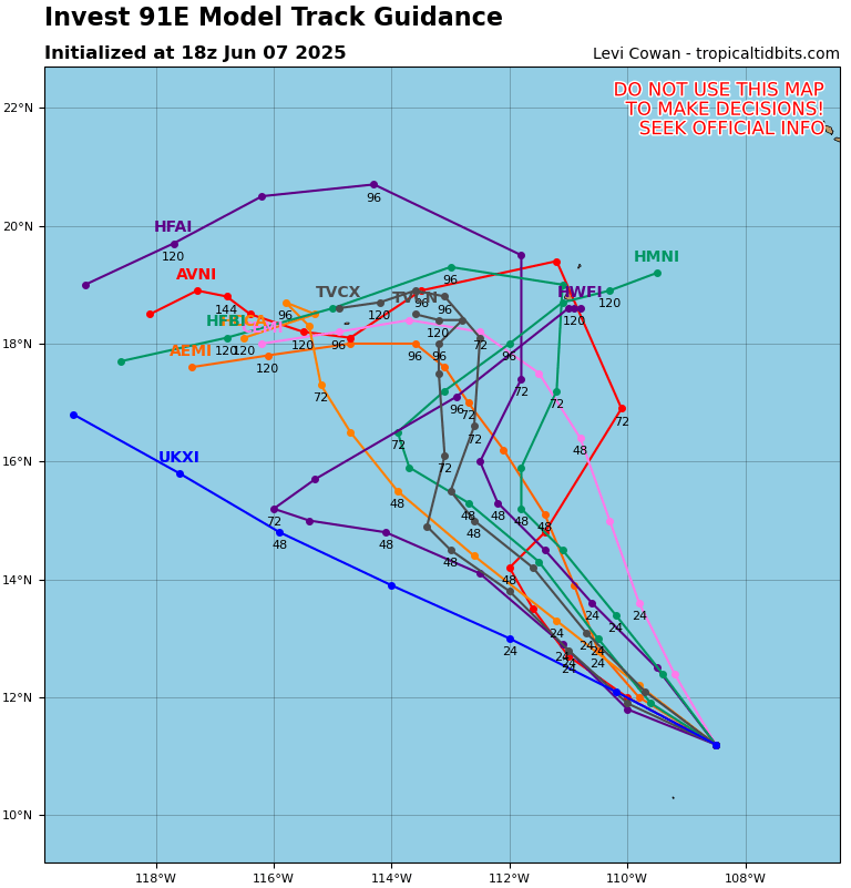
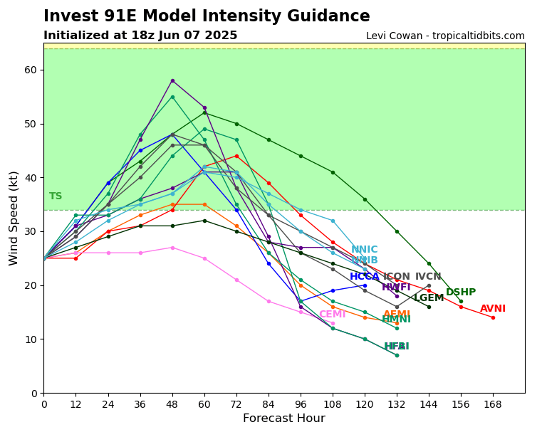
Disturbance 2, also known as Invest 91E (EP91), is the further west twin to Invest 92E. According to the NHC this system is has a 70% chance to form into a cyclone within the next 48 hours and an 80% chance within the next 7 days. This low pressure system is about 600 miles off the southwest coast of Mexico and has a low pressure of 1007-mb. Invest 91E is less organized than Invest 92E but is still producing showers and thunderstorms over the open ocean. The system will follow a parallel path to Invest 92E but remain much further off the coast as it moves northeastward. In terms of intensity this storm is likely to only hit tropical depression status and at most tropical storm status over the next week. The main impacts this storm will have are on ocean waves and wind in this area way off the coast but will not affect any land for quite some time if ever at all.
Eastern Pacific Disturbance 3
Following in the footsteps of Invest 92E is a disturbance that is south of the Gulf of Tehuantepec. This low pressure system is not expected to develop into a cyclone within the next 48 hours, but has a 40% chance of development within the next week. There is a chance for this system to form into a tropical depression late next week and will be something to watch!
Why is the Pacific Getting All the Action?
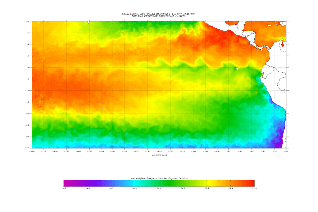
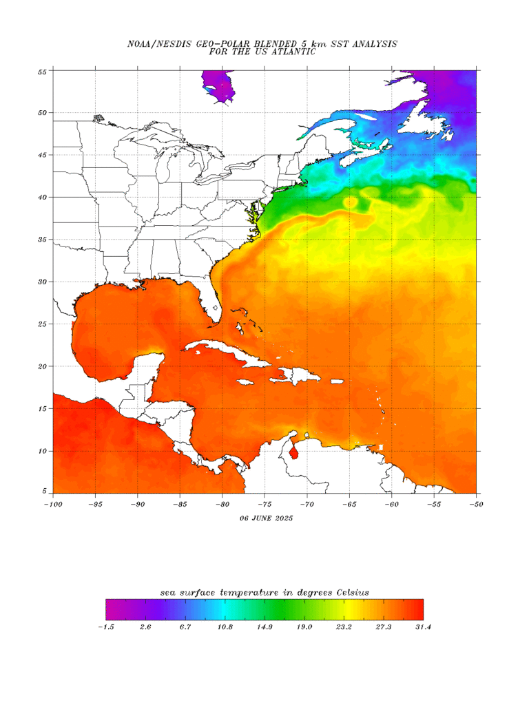
The reason why we are seeing so many disturbances in the Pacific right now is due to a few factors. Moisture in this region is big right now. We can see a lot of moisture off the southern coast of Mexico that will remain over the next week. However drier air over the Baja California coast is cutting off a lot of the development from moving closer to Mexico and into that region which is why we are seeing our invest’s paths going more westward. Another major player is warm ocean temperatures and with winds coming from the south which is bringing the warmer equatorial waters up along the coast. Warm ocean temperatures help with the moisture across the region and our moist areas correlate with our warmest sea surface temperatures (SSTs). These two factors are very important to tropical storm development over the coming week.
Will the Pacific Remain Active?
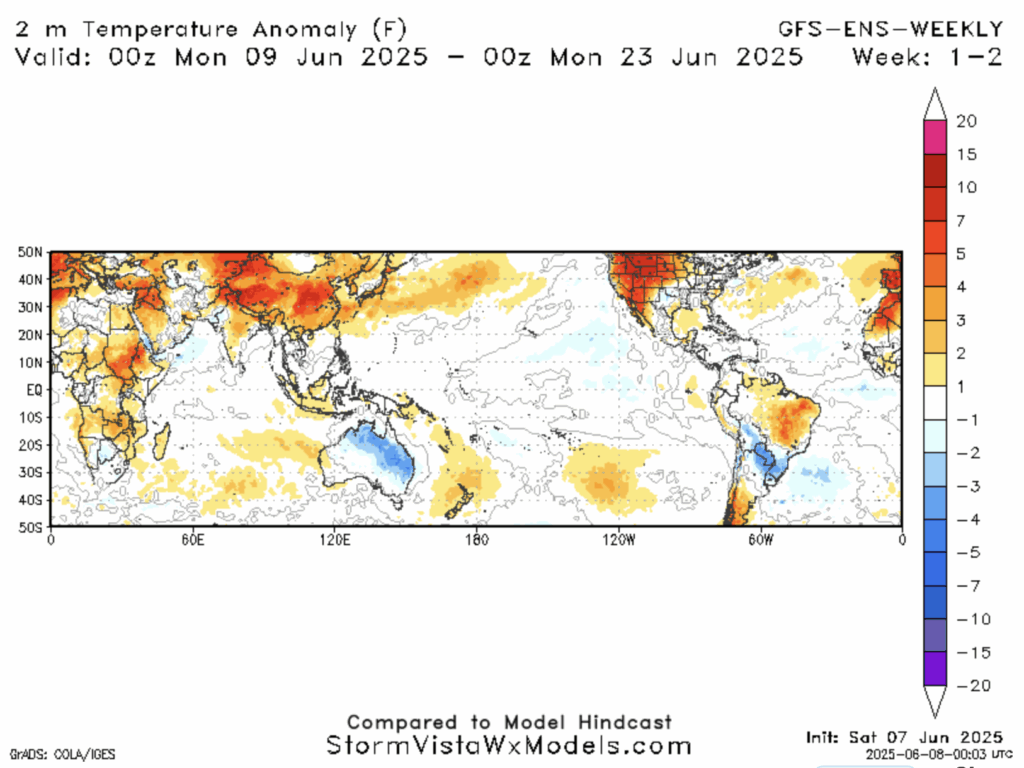
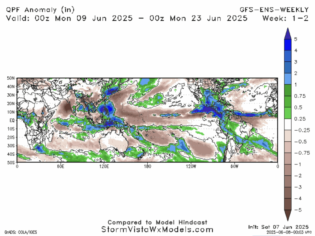
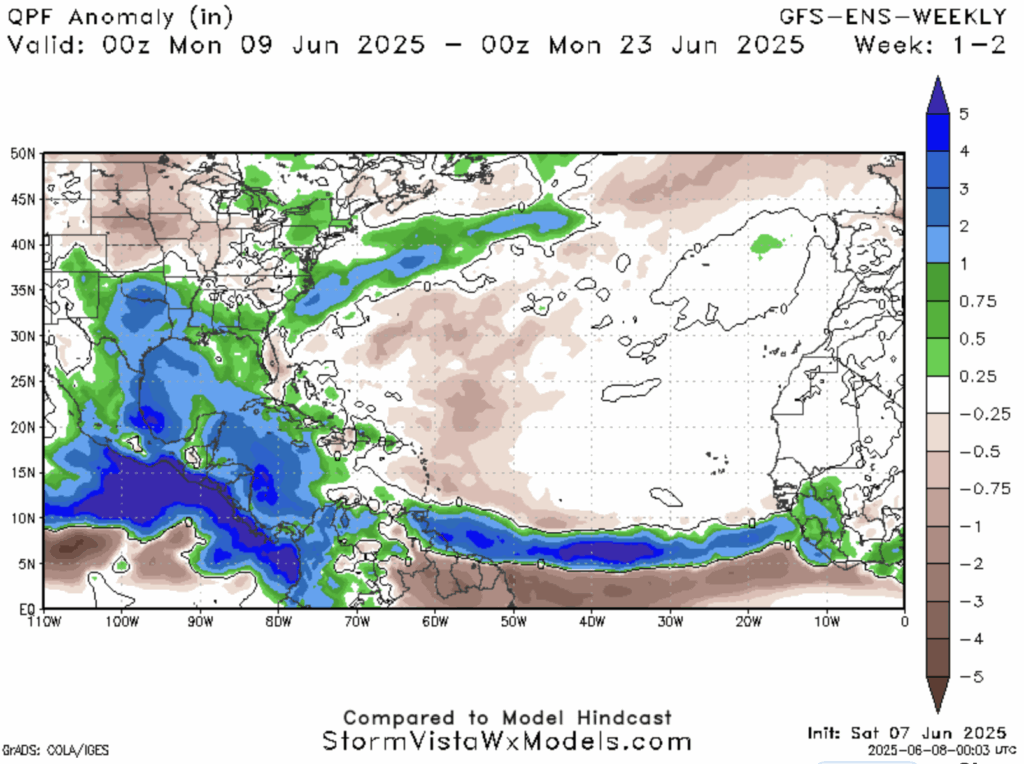
We are seeing lots of warm SST and moisture in the eastern Pacific currently, but will it last? Looking ahead we can expect SSTs to remain warm as we ahead closer to the summer solstice. However looking ahead throughout a composite of the next few weeks, we can see that surface temperatures remain warm but not unseasonably like it has been. This means the eastern Pacific won’t be much warmer or cooler which are not the most favorable conditions. The central Pacific isn’t looking too favorable either. There seems to be a high Quantitative Precipitation Forecast (QPF) for southern Mexico which tells us there was decent precipitation in the area. However, some of that can be accounted for from the disturbances that will be in the area this week and doesn’t necessarily mean we will see high moisture in that area in the following weeks. Overall, the eastern Pacific may slow down a bit after this week but with warm SST and no abnormal surface temperatures, I wouldn’t rule out the potential for more systems coming out of this region in June.
Lack of Atlantic Development
The NHC shows that the Atlantic has no expected tropical cyclone activity within the next 7 days. Why is this? Looking at the factors that are fueling the Pacific we see that there are warm SST in the Atlantic, and normally warm surface temperatures. However, what seems to be blocking a lot of storm systems from traveling along the Atlantic basin is the lack of moisture. Currently it is quite dry out in the Atlantic and even in the Gulf, the amount of moisture a system would need, just isn’t there. Even looking out at our multiple week composite of QPF, we see moisture along the normal cyclone path, but not as much as compared to the Pacific. Since we don’t see much moisture this week either, the composite weeks are likely seeing more QPF from later in the month. This means the Atlantic is taking its time to get into hurricane season. However, these factors don’t mean there can’t be some action, just that it is rather unlikely.
Conclusion
The Pacific is bustling with warmth and moisture while the Atlantic is seemly very dry right now. Invest 92E in the eastern Pacific looks the most promising for tropical cyclone development in the coming days which will be interesting to monitor. Its sister, Invest 91E looks to be less likely to develop into anything major. Disturbance 3 could be promising in the coming week with favorable conditions in the region. Plenty to look out for in the tropics and the season is just getting started. Be sure to check out all the tropical updates this week to stay up to date on what’s going on!


