Thanks to the trough and cold front to our north, another day of thunderstorms is possible. Models agree that a squall line (or to use a fancy meteorological term, a mesoscale convective system, or MCS for short) will form in central Texas, and it could impact the New Orleans area around dinnertime.
The question that will determine the weather setup is: Will this line be able to hold itself together before a lack of wind shear causes the storm system to deform into merely scattered sub-severe thunderstorms?
It’s up in the air.
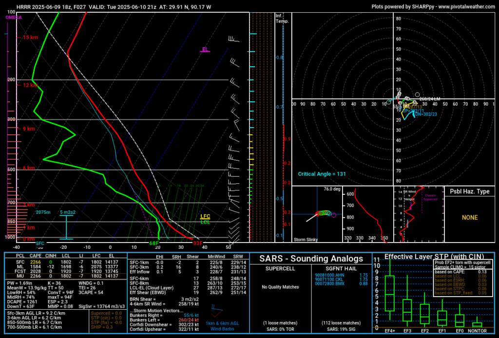
Given what I know, I would probably say that the squall line will be below severe limits by the time it reaches New Orleans. The line just has too much real estate to fight through, and most of Louisiana will be in a low-shear environment at best. Some Skew-T simulations, like the one below, even suggest a backing upper-level shear that cancels out the lower-level shear.
On this point, the models agree, both the HRRR and ECMWF show a weaker line of storms moving through, the GFS doesn’t have anything at all. In Mississippi and even more so in Alabama, conditions will be even less favorable and it will be less likely the squall line reaches with severe intensity.
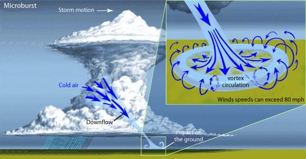
With any squall line in this part of the country, discrete thunderstorms ahead of the parent squall line are a threat, especially if there’s low-level instability like there is with this setup. DCAPE values are over the 1,000 Joule per kilogram threshold that we would expect downbursts to be a concern. Downbursts are a sudden release of energy from a thunderstorm’s core, and they can produce torrential rainfall and damaging winds. A downburst is probably the best chance most of Mississippi will have at seeing severe-level winds. If you’re on the road when a downburst strikes, take it very slow, or pull over if that is a safer option in your judgement.
Starting in the middle of the week, the mesoscale dynamics will shift, putting us in between two ridges. Humidity and moisture from the Gulf mean that showers and thunderstorms will be possible every day, although the ingredients aren’t in place for severe weather to be expected. The ECMWF shows a line of thunderstorms moving through in the afternoon basically every day. I’m skeptical that it will play out exactly like that, typically there’s at least one day it doesn’t rain.
As the two ridges get stronger into the weekend, it will likely get hotter and drier, especially inland. If you have outdoor activities planned this weekend, get ready to be hot, and please hydrate.
This is before troughing returns to our north around this time next week, potentially re-invigorating a severe weather threat.
REGIONAL DAY-TO-DAY FORECAST
Today: Mostly cloudy. Thunderstorms possible in the afternoon. Downbursts possible with discrete cells, squall line possible in New Orleans metro area around dinnertime. Highs in the high 80s. Chance of rain 50%.
Tonight: Mostly cloudy. Lows in the high 60s. Chance of rain 30%.
Wednesday: Showers and thunderstorms possible, especially in the afternoon. Highs in the high 80s. Lows in the high 60s. Chance of rain 60%.
Thursday: Showers and thunderstorms possible, especially in the afternoon. Highs in the low 90s. Lows around 70. Chance of rain 50%.
Friday: Showers and thunderstorms possible, especially in the afternoon. Highs in the low 90s. Lows in the low 70s. Chance of rain 50%.
Saturday: Partly cloudy. Highs in the mid 90s. Lows in the mid 70s. Chance of rain 30%.
Sunday: Partly cloudy. Highs in the mid 90s, with apparent temperatures above 100. Lows in the mid 70s.
Monday: Mostly sunny. Highs in the low 90s, with apparent temperatures above 100. Lows in the low 70s. Chance of rain 30%.
Tuesday: Showers and thunderstorms possible. Highs in the high 80s. Lows around 70. Chance of rain 50%
Wednesday: Showers and thunderstorms likely. Severe weather possible. Highs in the high 80s. Lows in the low 60s. Chance of rain 70%.
Thursday: Showers and thunderstorms possible. Highs in the high 80s. Lows in the low 70s. Chance of rain 40%.
Friday: Mostly cloudy. Highs around 90. Lows in the low 70s. Chance of rain 30%.


