It seems often times that in June in this part of the country, it isn’t prudent to forecast days that it will rain. It is instead more useful to try to pick out the days it WON’T rain. In my last local forecast on Monday, I expressed hope that one day this weekend would be rain-free, as a ridging pattern looked to assert itself.
Unfortunately, that scenario seems unlikely now.
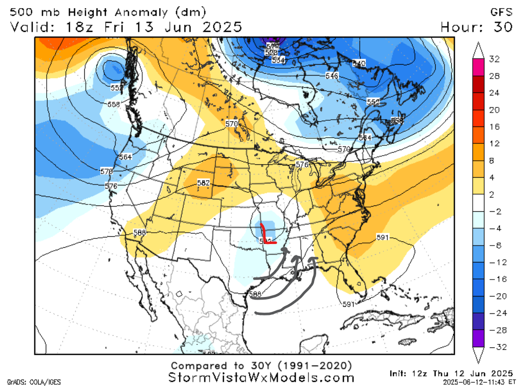
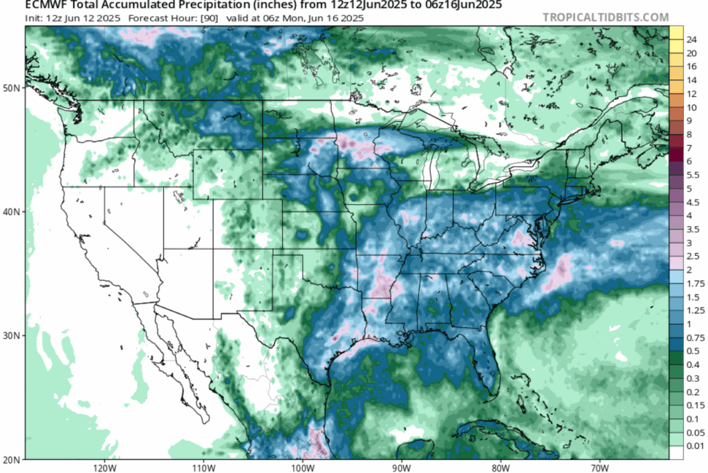
The trough over Texas, Oklahoma, and Arkansas was stronger than anticipated. This is important because a low pressure in this part of the country will pull up moist air from the Gulf into the forecast area. Vorticity levels and an overall moist setup will set the stage for several rounds of rain and thunderstorms today and this weekend. In the late afternoon and early evening, after most of the daytime heating has occurred, will be the best chance for storms each day.
Weak upper-level winds mean that while storms should remain sub-severe, storms that do form will be slow moving and could produce localized flooding. Turn around, don’t drown when encountering flooded roads. Mid-level instability may also be intense enough, especially along the Coast, for microburst formation.
Temperatures this weekend will be average for this time of year. But because of the higher dewpoints with the moisture coming up from the Gulf, we can expected very uncomfortable apparent temperatures above 100 degrees in areas without cloud cover. Rain may feel quite refreshing for those who are outside for prolonged periods.
BEYOND THIS WEEKEND
Looking ahead, the low pressure and trough to our north is replaced by high pressure and ridging. This will mitigate the rain threat just a little bit for a time, as wind will be blowing offshore instead of onshore, and the ambient air will be marginally less humid. While rain cannot be ruled out any day in particular, especially given a potential extra shot of moisture from the tropical activity in the Pacific, you have a better chance of avoiding rainfall by the middle of the work week.
Beyond that, as the high pressure moves east of us, precipitation potential will return to normal late in the work week into next weekend as another trough asserts itself in the Great Plains. Models are in preliminary agreement about a trough asserting itself in the 8-10 day time frame across the eastern two thirds of the lower 48, which would bring a more permanent dry pattern to the Southeast.
A LOOK AT THE TROPICS
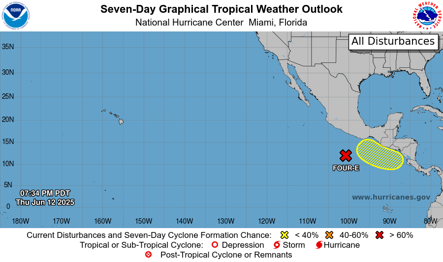
The western Pacific continues to be a factory of tropical systems. We’ve already had 3 named storms, and with warm waters and low shear, conditions remain favorable. Potential tropical storm four-E is likely to go west out into the Pacific Ocean, although Tropical Storm Watches have been issued for southern parts of Mexico, as tropical storm force winds could reach the coast depending on eventual storm intensity. There’s also a chance of tropical formation in the yellow shaded area in the next 5-7 days, which bears watching due to favorable conditions and its proximity to Mexico.
DAY-BY-DAY FORECAST
Friday: Highs around 90. Afternoon thunderstorms likely. Downbursts possible in some thunderstorms. Chance of rain 80%. Apparent temperatures over 100.
Friday Night: Lows in the low 70s. Residual rainfall possible. Chance of rain 40%.
Saturday: Highs around 90. Afternoon thunderstorms likely. Chance of rain 80%. Lows in the low 70s.
Sunday: Highs in the low 90s. Afternoon thunderstorms likely. Chance of rain 70%. Lows in the mid 70s.
Monday: Highs in the low 90s. Afternoon thunderstorms likely. Chance of rain 70%. Lows in the low 70s.
Tuesday: Highs around 90. Afternoon thunderstorms possible. Chance of rain 50%. Lows around 70.
Wednesday: Highs in the low 90s. Chance of rain 30%. Lows around 70.
Thursday: Highs in the low 90s. Afternoon thunderstorms possible. Chance of rain 40%. Lows in the low 70s.
Friday: Highs in the mid 90s. Afternoon thunderstorms possible. Chance of rain 60%. Lows in the mid 70s.
Saturday: Highs in the mid 90s. Chance of rain 40%. Lows in the mid 70s.
Sunday: Highs in the mid 90s. Chance of rain 30%. Lows in the mid 70s.
Monday: Highs in the mid 90s. Chance of rain 30%. Lows in the mid 70s.


