Pack your umbrella in the southeast because the subtropical jet continues to move storms across the area with a slow moving stationary front. The ridging in the plains is starting to move northeastward leaving some showers behind it. Some storms are developing in the northeast leaving only the west coast dry. Changes in patterns will eventually let the storms move out and hot weather to move in.

[wpcode id=”41149″]
Central Oklahoma, Southeast, and Ohio Valley Severe Storms
The SPC shows central Oklahoma as the main focus in the early morning with a Moderate risk placed over the area. A convective thunderstorm produced by low level lift is expected to produce hail and damaging winds. The storm cell will move eastward throughout the day but lose some of its intensity and organization. There is a possibility for cyclonic formation with the strong instability in the atmosphere. Heavy rainfall is expected so flash flooding in these areas is possible. Be cautious with the chance for hail up to a quarter inch. Stay indoors if you hear thunder.
In the Ohio Valley a cluster of severe storms are pushing eastward toward the DC area late into Friday early Saturday morning. Some of these clusters may be severe. Rainfall will affect much of the northeast starting Friday afternoon and continue until mid afternoon Sunday. Flash flooding can occur in these areas especially near small streams and ponds.


[wpcode id=”41149″]
Rain Across Much of the U.S.
Looking at our current radar we see much of the U.S. covered under rainfall. Due to the major low pressure system pushing through we will see a lot of scattered showers separating coast to coast. A big trough is affecting much of the Great Plains and Midwest region and bringing along a line of storms spanning from North Dakota down to Texas. On Friday we will see that large line of showers move southwest and start to dissipate. With the next line of storms following from the Rocky’s being pushed eastward by a high pressure system behind it.
The Pacific Northwest may see some rainfall starting Sunday night into Monday with a low pressure cyclone coming from the south of Alaska. The rainfall will be pushed northward by Wednesday by a high pressure system which will bring in clear weather.
The Rocky Mountains region will see some scattered showers throughout the weekend followed by a few days of clear weather brought in by a high pressure ridge out west. The scattered showers this weekend may produce some more severe thunderstorms with heavy rainfall and chances for flash flooding.
The central plains region will see plenty of rain this weekend with a few different storm clusters moving through. Early next week clearer skies will finally appear followed by some possible severe weather late next week.
Texas and Oklahoma will see another cyclone on Sunday producing some severe thunderstorms. Clear weather will be in the cards next week as the major low pressure system moves eastward.
The Ohio Valley region will see rainfall early Friday but will clear in the evening hours. Some storm clusters will stick around early next week on the tail end of the low pressure cyclone.
The Northeast will see rain all weekend starting Friday afternoon as the major low pressure cyclone moves through followed by a warm front. Early next week has some scattered showers forecasted for the area to keep an eye out for.

[wpcode id=”41149″]
Looking For Some Heat? Head to Texas!
Summer is only days away but the heat is headed our way for much of the US Today much of Texas will be in the high 90’s with parts of southern Texas reaching highs of 100+. Much of the southern US will see highs in the high 80’s to low 90’s. The hot weather will extend across the midwest with temperatures in the mid to upper 80’s in many parts. Colorado will see the coolest weather with the higher elevations today. For the weekend much of the northern US will see cooler temperatures with the south remaining warm.
When working outside in hot weather be sure to hydrate and take breaks in inside frequently. The heat index for much of the southern US will be high for much of the upcoming days so be prepared. Be sure to also wear sunscreen as the UV index starts to increase in the summer months.

[wpcode id=”41149″]
Today’s Travel Implications
Due to the heavy rainfall across much of the US travel with caution. Many major interstates will be affected by rainfall. Be cautious while driving and be aware of limited visibility. Morning flights out of the Southeast may be effected by the high winds and heavy rainfall. In the afternoon flights coming from major cities such as DC, Philly, and NYC may be delayed due to the storms. When traveling in higher elevations like the Rocky’s be aware of the winds especially in high-profile vehicles.
Extended Outlook
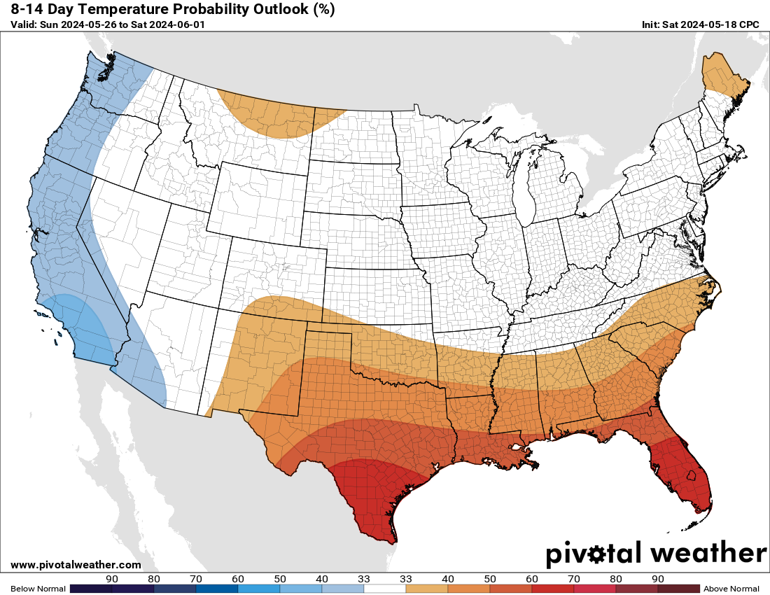
Looking ahead as we kick off summer hot temperatures will start to build in the southern region due to a ridge building in the central plains. The ridge will bring some clear weather after all the wet weather this weekend. For the western US a trough is going to bring in some more wet and cool weather throughout the week. We can expect some changes in weather patterns as we advance into the end of June with some high pressure systems starting to enter the states hopefully bringing some more sun!
As we can see the 8-14 day temperature outlook shows much of the central US above normal with hot temperatures. The west coast will see a slightly cooler temperatures as well as the east coast most likely due to their temperatures fluctuating less.
Conclusion
With a major low pressure system bringing in some wet weather for much of today and the weekend to come, some hopefully changes in the weather pattern will bring some more clear skies for much of the US next week. This will help give a break to those who were effected by some of the more severe weather earlier this week. Temperatures will start to feel more summer like and many will be able to enjoy the change of scenery. Always be sure to hydrate and be cautious in extreme heat. Many areas could possibly see some scattered rain and areas like Colorado and the northeast are worth watching this weekend.


