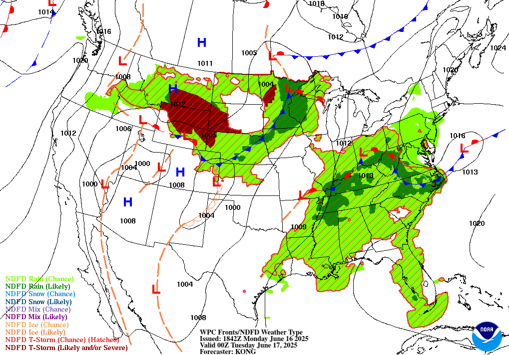
Temperatures today will be seasonably cool, with many areas struggling to hit 90 degrees. A moderate trough to our northwest, attached to a low pressure, is advecting moisture from the Gulf, increasing the probability of precipitation today.
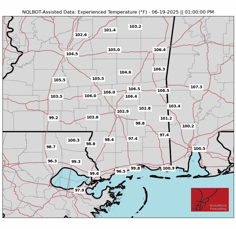
The trough will blow through on Wednesday, reducing probability chances after it passes, but a cold front from the Plains will drop down Wednesday night into Thursday and provide a lifting mechanism for more convection on Thursday, which coincides with the Juneteenth holiday. The positioning of this cold front will be the difference between only having “kind of hot” apparent temperatures and “very hot” apparent temperatures. Looking at the map, especially in inland areas away from the sea breeze, the western central portion of our forecast area is forecasted to feel 8-10 degrees cooler than similar latitude locations in the east of our forecast area.
Since we’re far away from the parent low associated with this cold front, temperatures and humidity won’t remain low for long. Friday we’re right back to seasonal high temperatures and a dreaded chance of thunderstorms.
This weekend a ridge begins building, which will encourage subsidence. This means that not as much rain will fall, but it will be very hot. Depending on if pressure anomalies are less intense than expected, there may be a marginal damaging wind risk if discrete cells form.
NEXT WEEK
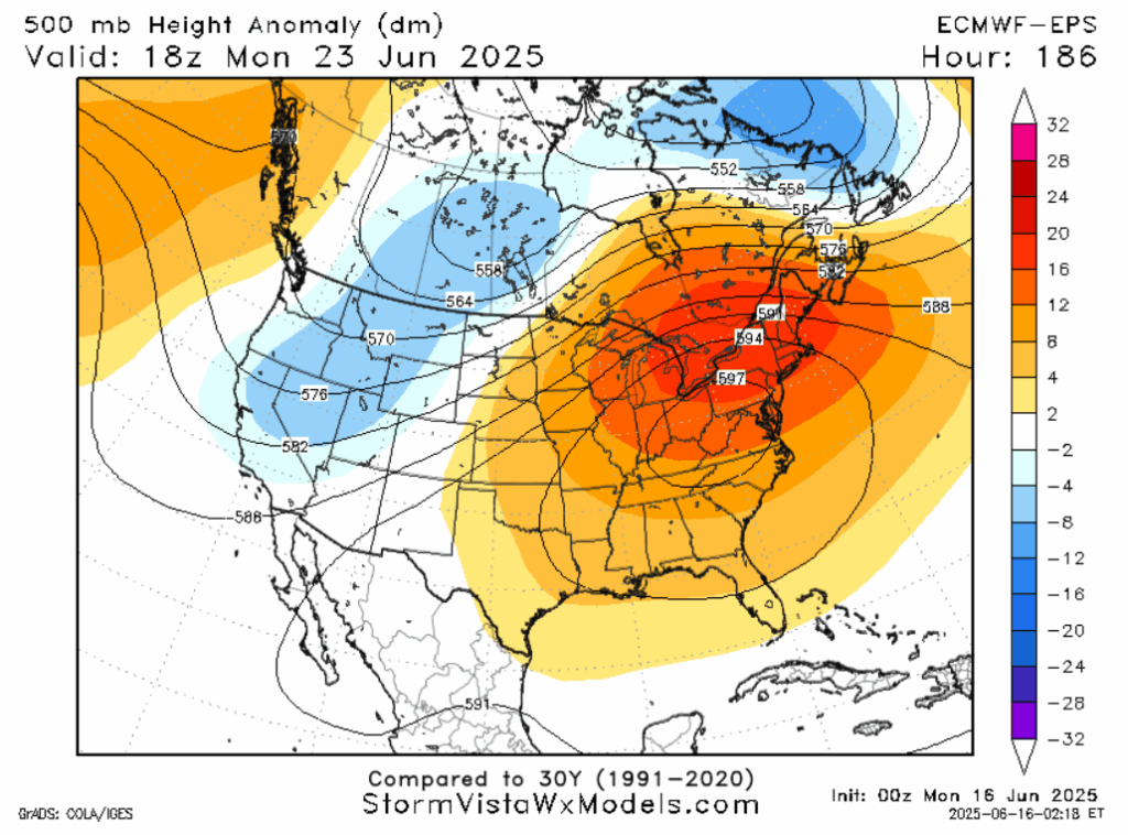
A big time heat dome is going to set up over the Mid-Atlantic and Central Appalachia. Our forecast area will be on the periphery of the ridge that is producing this hot weather, but it’s still a decent bet temperatures will be above average next week. Moisture from the tropical systems in the Pacific, combined with the Bermuda High being further east than typical, causing wind to blow up from the Gulf, mean that we can expect wetter than average conditions on the aggregate next week as well.
A LOOK TO THE TROPICS
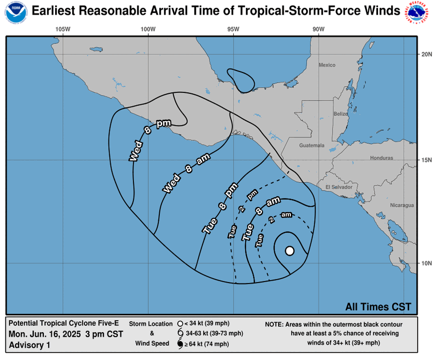
It is likely that Hurricane Erick will form south of Mexico sometime today, and on Thursday it will make landfall as a strong tropical storm or Category 1 hurricane in the Mexican states of Oaxaca and Guerrero. This area was also impacted by the outer bands of Tropical Storm Dalila, making flooding and mudslides a possibility. There’s a slight chance moisture from this storm may impact Louisiana or even Mississippi next week, so stay tuned.
DAY-BY-DAY FORECAST
Today: Highs around 90. Mostly cloudy. Rain and thunder, especially in the late afternoon. Rainfall around a half an inch, locally higher amounts in thunderstorms. Chance of rain 70%.
Tonight: Lows in the low 70s. Mostly cloudy.
Wednesday: Highs in the mid 90s. Mostly sunny. Chance of rain 30%. Lows around 70.
Thursday: Highs around 90 west, highs in the mid 90s east. Partly cloudy. Thunderstorms possible all day. Chance of rain 70%. Lows in the low 70s.
Friday: Highs in the mid 90s. Partly cloudy. Afternoon or early evening thunderstorms possible. Chance of rain 50%. Lows in the mid 70s.
Saturday: Highs in the mid 90s. Mostly sunny. Afternoon or early evening showers and thunderstorms possible. Chance of rain 40%. Lows in the mid 70s.
Sunday: Highs in the mid 90s. Mostly sunny. Afternoon showers possible. Chance of rain 40%. Lows in the mid 70s.
Monday: Highs in the mid 90s. Partly cloudy. Afternoon thunderstorms possible. Chance of rain 50%. Lows in the mid 70s.
Tuesday: Highs in the mid 90s. Mostly cloudy. Afternoon thunderstorms possible. Chance of rain 70%. Lows in the mid 70s.
Wednesday: Highs in the mid 90s. Partly cloudy. Afternoon thunderstorms possible. Chance of rain 50%. Lows in the mid 70s.
Thursday: Highs in the mid 90s. Partly cloudy. Afternoon thunderstorms possible. Chance of rain 50%. Lows in the low 70s.
Friday: Highs in the low 90s. Mostly cloudy. Afternoon showers or thunderstorms possible. Chance of rain 40%. Lows in the low 70s.


