It’s an Independence Day miracle!
It seems like we will have nearly completely dry conditions throughout the Pine Belt today. A high pressure to our north and a ridge to our west are keeping the Gulf moisture at bay. And the cherry on top: Since dry air is being advected, humidity will be decreased and heat indexes will be comparably below average.
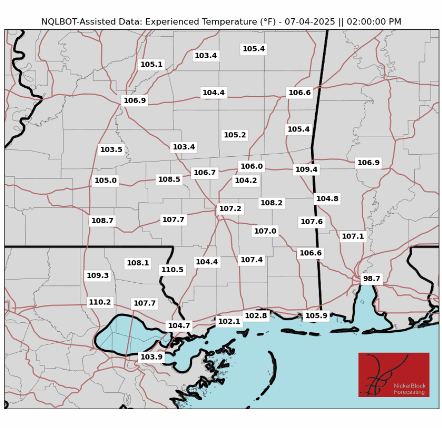
While still in the triple digits, “experienced temperatures” will likely be below 110 for most if not all of the day in the forecast area, with possible exceptions being in the early afternoon in the Pine Belt and further west, with locally higher humidity. Some light northerly breezes will feel pleasant.
It will be a gorgeous night, with temperatures in the Pine Belt in the upper 80s at 9PM, with no rain and very light wind. Perfect firework weather.
THIS WEEKEND
As the ridge and high pressure mentioned earlier move on west, the Gulf moisture will have a fighting chance. Apparent temperatures will increase by 3 degrees as more moist air moves in and northern breezes subside. There could also be some localized convection, leading to afternoon thunderstorms, that will cause a 20-30% chance of rain on both days this weekend.
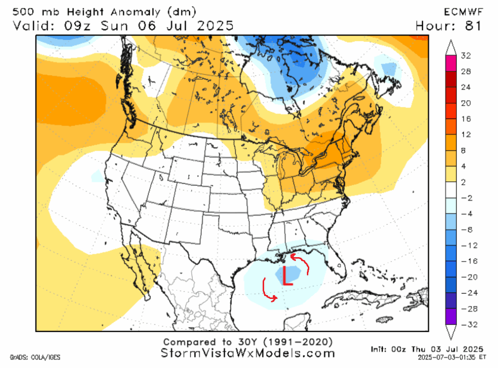
On Sunday, the current high pressure in the gulf will be replaced with a trough, potentially rotating up more Gulf moisture and causing upward forcing needed for convection. Sunday looks to be the wetter day this weekend.
NEXT WEEK
We can’t have nice things for too long. Eventually the heating from the sun being out all day will catch up with us, as rain will increase back to normal to slightly above average levels overall. We also anticipate above normal temperatures along the Gulf coast, with several days reaching above the 95 degree threshold. The higher temperatures combined with high precipitable water values (a measure of the total moisture in all layers of the atmosphere) will further contribute to above average rainfall. Tuesday or Wednesday may contain severe weather depending on the timing of various synoptic and mesoscale level features.
LOOKING TO THE TROPICS
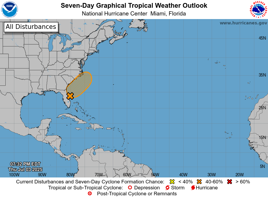
We may have a storm forming off the coast of the southeastern United States in the next few days. If it forms, it is unclear whether if the storm center will impact the Carolina coast, bringing wind and surge, or if it will stay offshore and just merely make things rainy for the area.
Out in the Pacific, Flossie has weakened to a post-tropical cyclone and will curve safely out to sea. Another storm will form behind it in the 2-4 day time frame, which should stay far enough from land to not have any impacts.
DAY-BY-DAY REGIONAL FORECAST
Today: Highs in the low 90s. Mostly sunny. Northern breeze of up to 5 mph.
Tonight: Lows in the mid 70s. Mostly clear.
Saturday: Highs in the mid 90s. Partly cloudy, chance of an afternoon thunderstorm. Lows in the mid 70s. Chance of rain 20%.
Sunday: Highs in the mid 90s. Partly cloudy, chance of an afternoon thunderstorm. Lows in the mid 70s. Chance of rain 50%.
Monday: Highs in the mid 90s. Partly cloudy, chance of a thunderstorm. Lows in the mid 70s. Chance of rain 40%.
Tuesday: Highs in the low 90s. Partly cloudy, chance of a thunderstorm. A few storms may be severe. Lows in the high 70s. Chance of rain 40%.
Wednesday: Highs in the low 90s. Partly cloudy, chance of a thunderstorm. A few storms may be severe. Lows in the mid 70s. Chance of rain 50%.
Thursday: Highs in the low 90s. Mostly cloudy, chance of a thunderstorm. Lows in the high 70s. Chance of rain 50%.
Friday: Highs in the mid 90s. Mostly cloudy, chance of a thunderstorm. Lows in the high 70s. Chance of rain 40%.
Saturday: Highs in the mid 90s. Partly cloudy, chance of an afternoon shower or thunderstorm. Lows in the mid 70s. Chance of rain 40%.
Sunday: Highs in the low 90s. Partly cloudy, chance of an afternoon shower or thunderstorm. Lows in the mid 70s. Chance of rain 40%.


