Today we can expect “feels like” temperatures to break 105 degrees in many locations in our region today, and scattered afternoon and evening showers to pop up around the area. A thunderstorm or two cannot be ruled out either. Moving into the rest of the week and weekend, high heat indices will continue to affect our region, so being careful while outside and keeping an eye out for any heat advisories will be very important this week!
Overall Setup in the Atmosphere Today:
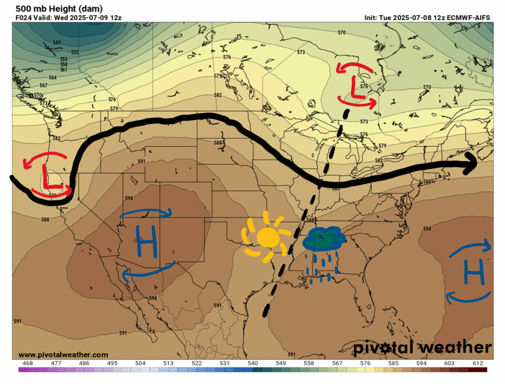
Looking at our upper-air chart, we can see that our region is under a trough squished between two ridges with associated high pressure areas; one over the Southwest and the other over the Atlantic, also known as the Bermuda High. There is also a closed low pressure area over Northern California. The positively tilted trough axis mean increased rain and storm chances for our area, but these storms most likely won’t be severe.
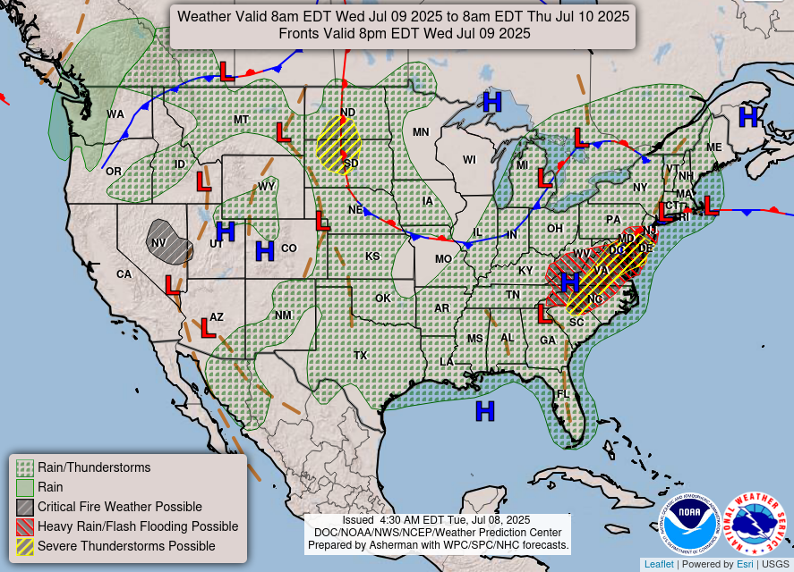
Moving down to our surface chart, we can confirm that rain and thunderstorms are probable for our region today. Remnants from Tropical Storm Chantal will continue to affect the East Coast, with risks for heavy rain, flooding, and severe thunderstorms possible in the Mid-Atlantic.
Today’s Weather:
Temperatures will reach the low 90s in many areas in our region today with dewpoints reaching the 70s, so it’s going to feel much warmer than the actual temperature. For a more detailed look, check out the experienced temperatures for today at noon:
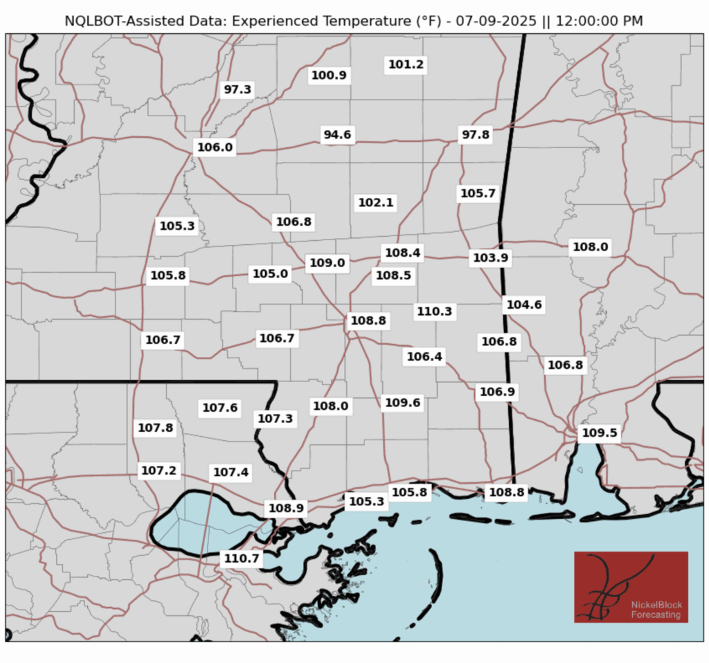
With heat indices breaking 100-105 degrees on most places today, it will be very important to be careful in the heat and take extra precautions if you plan on spending time outside during the day today. As for rain, there is a good chance for afternoon showers and even a thunderstorm during the afternoon and early evening anyway:
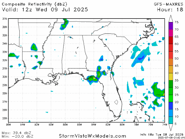
Looking at today’s radar, we can expect some scattered showers and possibly a storm here and there beginning in the afternoon, and persisting into the evening. Not every location in our forecast region will receive rain, but many areas will, so it’s not a bad idea to give a quick look at the radar before heading outside.
Weather for the Rest of the Week and into the Weekend

Tomorrow there are showers and thunderstorms possible throughout the day, particularly early in the morning and later on in the afternoon/evening. Chances for afternoon showers and storms will continue throughout the rest of the week/weekend, and even into next week, as another trough is forecasted to form and move across our region over the weekend. High heat indices will also continue through tomorrow and the weekend, and the NWS Jackson office has even put out an announcement:
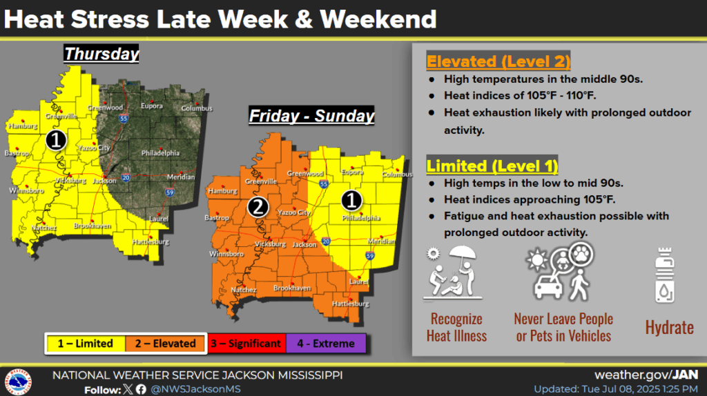
I wouldn’t be surprised if the NWS issued a heat advisory or two on Friday and over the weekend, since heat indices are forecasted to break the heat advisory threshold for the region. So, keep all this in mind if you are planning any outdoor activities this weekend, and stay safe in the heat!
Regional Day-to-Day Forecast
Today: Mostly sunny during the morning, with a chance of rain and thunderstorms in the afternoon. Highs in the low 90s. Chance of precipitation 60%.
Tonight: Chance of showers and thunderstorms early on in the evening. Lows in the low 70s. Chance of precipitation 60%.
Thursday: Chance of showers and thunderstorms throughout the day. Highs in the low 90s during the day and lows in the mid 70s at night. Chance of precipitation 80%.
Friday: Mostly sunny during the morning, with a chance of rain and thunderstorms in the afternoon. Highs in the low 90s during the day and lows in the mid 70s at night. Chance of precipitation 70%.
Saturday: Mostly sunny during the morning, with a chance of rain and thunderstorms in the afternoon. Highs in the mid 90s during the day and lows in the mid 70s at night. Chance of precipitation 50%.
Sunday: Mostly sunny during the morning, with a chance of rain and thunderstorms in the afternoon. Highs in the mid 90s during the day and lows in the mid 70s at night. Chance of precipitation 50%.
Monday: Sunny during the morning, with a chance of rain and thunderstorms in the afternoon. Highs in the mid 90s during the day and lows in the mid 70s at night. Chance of precipitation 50%.
Tuesday: Sunny during the morning, with a chance of rain and thunderstorms in the afternoon. Highs in the mid 90s during the day and lows in the mid 70s at night. Chance of precipitation 60%.
Wednesday: Mostly sunny during the morning, with a chance of rain and thunderstorms in the afternoon. Highs in the mid 90s during the day and lows in the mid 70s at night. Chance of precipitation 50%.


For me it is difficult to tell from reading this information when the high pressure is likely to reach the ms/al coast. And I guess is typical that some forecasters have the weekend at 50% and others have it at 20% forecast of rain/thunder storms. I watch WWLTV via YouTube a good bit but live in south MS. They are forecasting 20-30% rain chances Saturday.
Thanks, I do enjoy reading Nickelblock.com each morning.