The dog days of summer are here. Temperatures and dew points will reach uncomfortable levels today, with apparent temperatures potentially reaching 110 degrees in the Pine Belt. Trouble is coming from the east, with a possible tropical system that could drop rain Thursday through Saturday. But after this, a ridge could build, returning drier conditions to the forecast area.
TODAY AND TOMORROW
A surface high pressure system from the Gulf is making it’s way through the forecast area, bringing with it clear skies, warmth, and humidity. In the 1-3PM timeframe, temperatures will peak around 95 degrees, with dewpoints in the low 70s. It will be pretty clear, with the sun not being blocked by clouds most of the day. All of these factors will combine to make it an oppressively hot day.
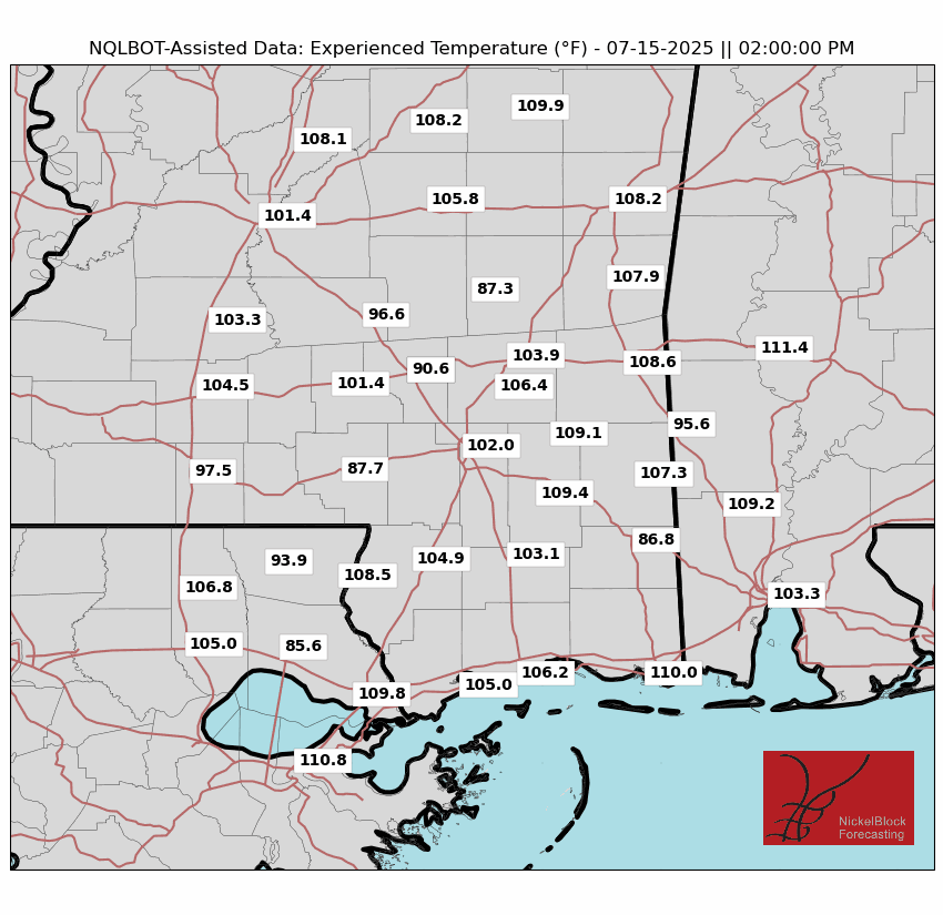
The high humidity at the surface does open the door for the possibility of showers, but drier air aloft and subsidence from the high pressure will inhibit the growth of storms. Some lucky areas could get a refreshing shower that will decrease temperatures, but probabilities of precipitation are no more than 20%.
Low temperatures should retreat to the low 70s overnight as the high pressure passes. Expect similar conditions on Wednesday, with a slightly higher precipitation chance in the western reaches of our forecast area as the high pressure leaves the area.
REST OF THE WEEK – TROPICAL THREAT
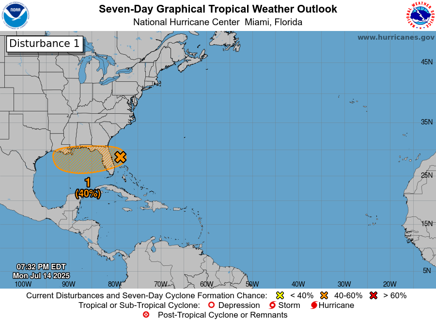
Murmurs of a “Gulf low” have been bubbling for about a week now. As of now, a surface low in a favorable tropical environment is off the East coast of Florida, moving west. By the time you read this article, it may already be over the Florida peninsula.
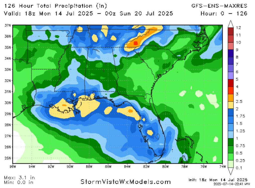
The center of the low will move into the Gulf, entering an area of very warm ocean water and ample moisture, albeit moderate shear. The NHC is forecasting a 40% chance of tropical development in the orange highlighted area. If the low can find a weaker area of shear, the right conditions exist for tropical storm development. ECENS model runs do show the storm curving up into southeastern Louisiana late Friday into early Saturday. This would put our forecast area in the “front right sector” that carries with it a tornado risk. Models show an “ambient” 1-2 inches of rain falling during the Thursday-Saturday time frame, with locally higher amounts. More potent rainfall in the southwestern reaches of our forecast area, or any area that is under a band of rain for multiple hours, is expected. Flash flooding is possible.
During this time period, high temperatures will range from the high 80s to low 90s, with the former more likely if rain cools things down in the late morning and early afternoon. Precipitable water and vertical velocity looks more conducive for rainfall, even ahead of the storm, beginning Thursday.
NEXT WEEK – DEATH RIDGE RETURNS?
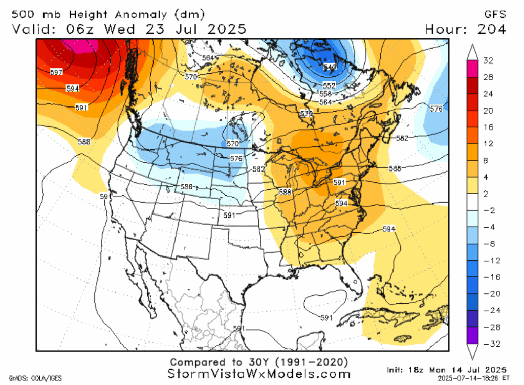
Both mainline medium-range models are in agreement that a ridge will form in the eastern United States next week, including our forecast area. The 3 teleconnections that impact local temperatures (AO, PNA, ABNA) will all be in their warmer phases during this time. The Climate Prediction Center has put around 90% of the country under a forecast for above average temperatures in the 8-14 day time frame, including our area. Once the tropical moisture leaves the area, the ridge will also return our area to average to slightly below average rainfall. Hotter air will destabilize the atmosphere, but there won’t be as much moisture available to take advantage of that instability to produce rain.
DAY-TO-DAY REGIONAL FORECAST
Today: Highs in the mid 90s. Humidity will increase the heat index to hazardous levels. Partly cloudy. Wind between 5 and 10 miles per hour.
Tonight: Lows in the low 70s. Mostly clear.
Wednesday: Highs in the mid 90s. Humidity will increase the heat index to hazardous levels. Partly cloudy. Chance of rain 20%. North wind around 5 miles per hour. Lows in the low 70s.
Thursday: Highs in the low 90s. Partly cloudy. Chance of rain 40%. East wind around 5 miles per hour. Lows in the mid 70s.
Friday: Highs in the low 90s. Mostly cloudy. Chance of rain 60%. A few storms may be severe late. Lows in the mid 70s.
Saturday: Highs in the low 90s. Mostly cloudy. Chance of rain 70%. A few storms may be severe early. Lows in the mid 70s.
Sunday: Highs in the mid 90s. Partly cloudy. Chance of rain 50%. Lows in the mid 70s.
Monday: Highs in the mid 90s. Mostly sunny. Chance of rain 40%, especially in the afternoon. Lows in the mid 70s.
Tuesday: Highs in the low 90s. Mostly sunny. Chance of rain 40%, especially in the afternoon. Lows in the mid 70s.
Wednesday: Highs in the low 90s. Partly cloudy. Chance of rain 40%, especially in the afternoon. Lows in the mid 70s.
Thursday: Highs in the mid 90s. Partly cloudy. Chance of rain 50%. Lows in the mid 70s.


