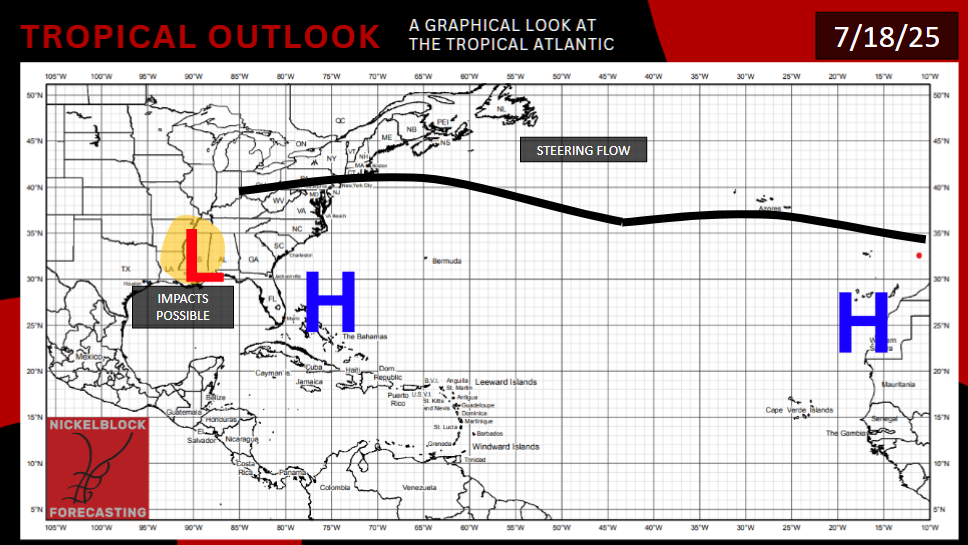
The center of Invest 93L is over Louisiana, moving north. It is dropping torrents of rain over the state. A radar estimate indicates the town of Belle River in Acadiana has received 11 inches of rain already (maybe more by the time you read this). Much of the southeastern part of the state has received 2 or more inches as a baseline. As the center of the storm begins to turn northwest, Southwestern Louisiana will get their fill of rain next, with the NAM showing rainfall amounts as much as 5-10 inches for some unlucky locations, with most areas in the region getting at least an inch. The Climate Prediction Center has issued a slight risk of flash flooding (15% in a 25-mile radius) today for most of Louisiana, as well as the Gulf coasts of Mississippi and Alabama, where proximity to the ocean will enhance rainfall totals, and models suggest a cluster of storms could move through. Other parts of these two states are still not out of the woods, as embedded thunderstorms could be convective in nature and drop lots of rain and perhaps a powerful wind gust. A marginal risk of flash flooding (5% in a 25-mile radius) is in place for the rest of Mississippi and most of the rest of Alabama, as well as eastern Arkansas and most of Tennessee, which will be affected later as the storm marches north. The risk to the north and east of those states on the map below are associated with a non-tropical event.

If you live near a body of water, make sure you are in a position where you can get warnings all day and night, and have a plan to get to higher ground if a flood begins to happen in your location.
EXTENDED OUTLOOK
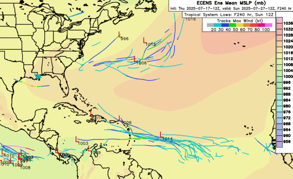
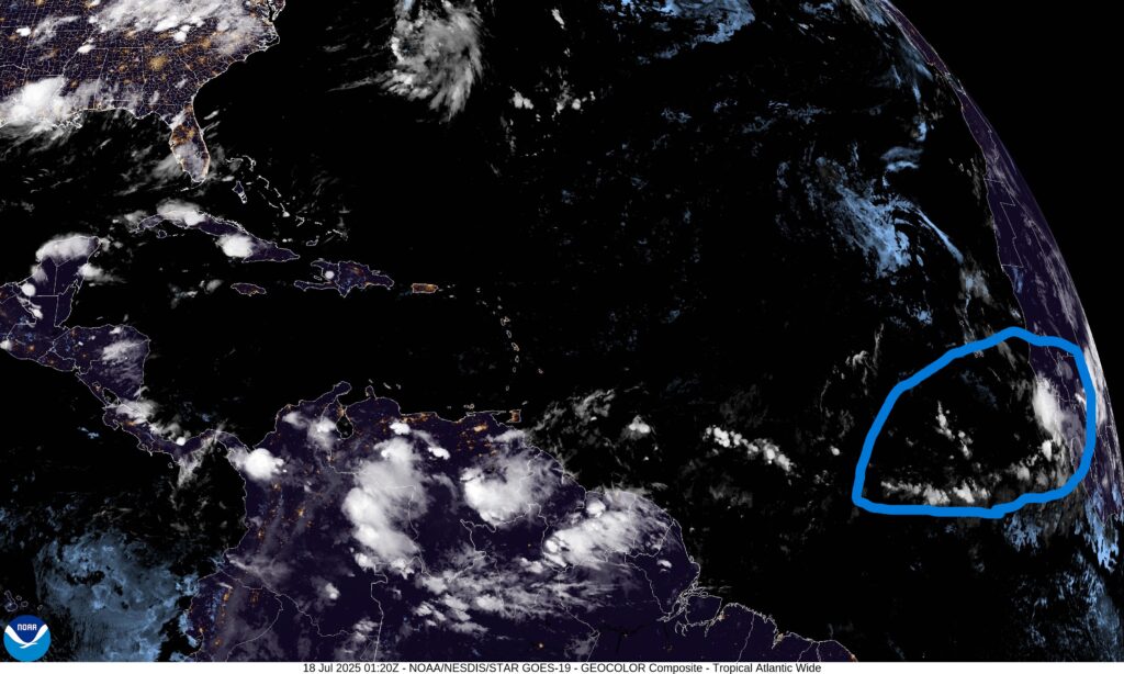
For the first time this year, we might have something to watch in the Mid-Atlantic. It’s not a great chance, but some ECENS ensembles do show a low pressure developing as soon as late Sunday, a few hundred miles east southeast of Cabo Verde. Satellite shows a potential tropical wave moving off the coast of the African nation of Guinea-Bissau. If these model ensembles are right, it would take time for these low pressures to develop into anything tropical. They would first have to move above 10 degrees north latitude, the general benchmark for where the Coriolis force is strong enough to generate tropical storms. (For reference, the northern tip of the country of Venezuela is about 10 degrees north). If it can get north enough, it will enter an area of warm enough water and only modest shear. If it gets going, it could reach the Lesser Antilles by the middle of the week next week, and eventually the Caribbean next weekend, if wind shear there is weak enough to allow the storm to make it that far.
Both the Gulf of Mexico and the Atlantic Ocean off the East Coast look to be drier and full of wind shear, making development in the next 5 days unlikely. There is a weak model signal for a tropical wave in the Gulf in the 6-9 day timeframe that could drop another round of rain for the region. There could be a break in the shear off the east coast of the southeastern United States, but anything that tries to form will have to contend with regions of very dry air. (The lows shown on the WeatherNerds picture in the area are not tropical in nature.)
A persistent shear layer over the Pacific Ocean south of Mexico, plus drier then average air, should stop anything from developing there in the next 7 days. Some models do suggest a storm could possibly form in the 8-14 day time frame after these conditions change, but it would likely ride the trade winds away from land.
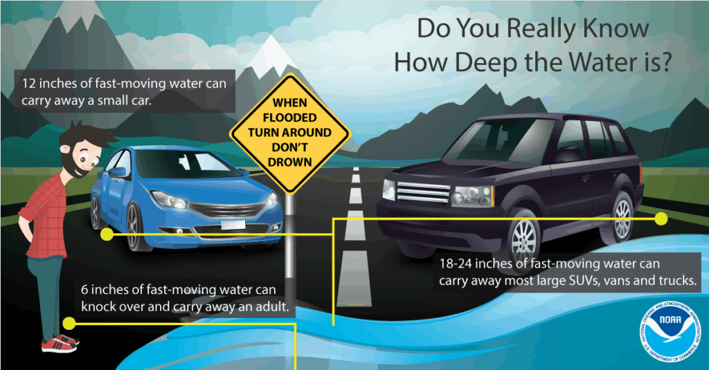
In light of recent events, I stress again: Make sure you have access to local, up-to-date flood information and warnings during the day and night if you live in a flood prone area in the Mississippi delta region. Have a plan to move to higher ground. And of course, turn around, don’t drown, when encountering flooded roads. Follow Nickelblock Forecasting on our website and app for future tropical updates.


