The current weather pattern across our area will undergo a big change. A cold front from the north will slowly move down and stall out to our south. This will put an end to the dangerous heat covering our area. Said cold front will also bring some rain to our area this weekend, especially today. In the middle of next week, the pattern will change again and the area will find itself in between two ridges, which is a sign of more normal weather.
TODAY – STORMS LIKELY
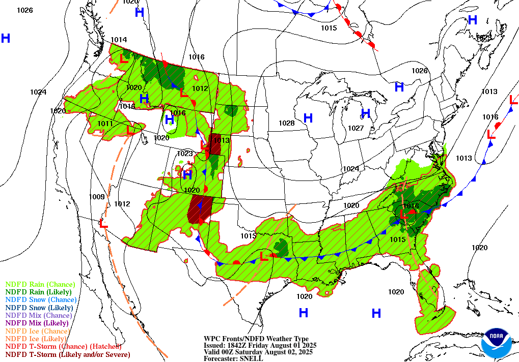
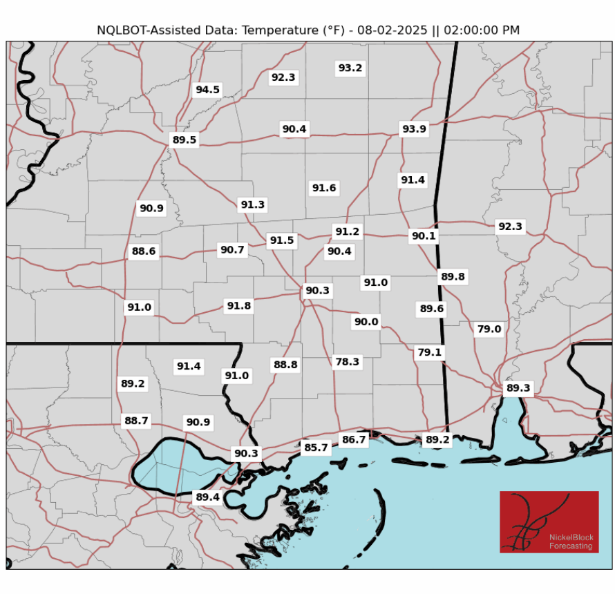
High temperatures will struggle to get much past 90 degrees as the front moves through late morning and early afternoon. A northerly breeze will signal the passage of the front. Cold fronts are known for bringing convection, and with high precipitable water values in the area, I’d bet on some thunderstorms across the forecast area in the afternoon, starting around 2pm and lasting the rest of the day. Rainfall totals will be between a quarter of an inch and a half an inch. While the mainline models are solidly calling for rain, some of the high-resolution model runs are more bearish on rain coverage. I’d put the rain odds between 60 and 70%, with some juice towards the upper end.
SUNDAY – RAIN POSSIBLE
The front will stall along the coast, and an area of low pressure will form along it. A trough will also begin to form to our north. So despite the cold front being past, a chance of afternoon showers and thunderstorms will persist. The rain chances will be lower, between 55 and 60%. The rainfall will also be less intense. Temperatures will similarly not get too far past 90 anywhere.

WORK WEEK FORECAST
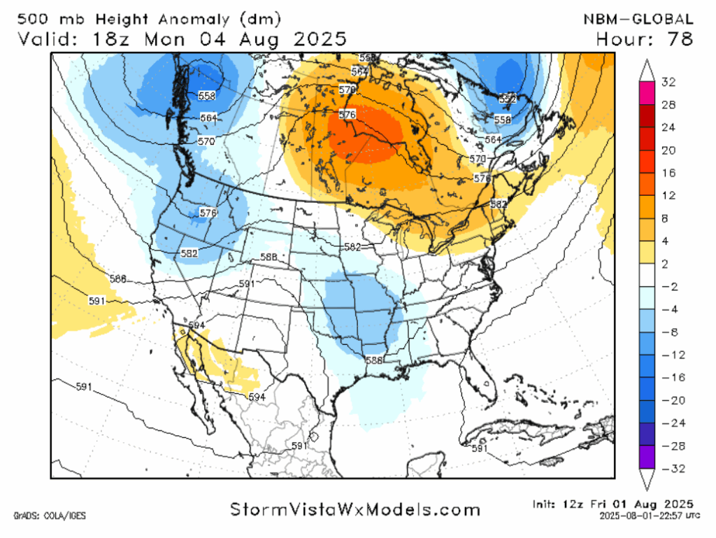
Monday and Tuesday, the trough centered to the north will strengthen, continuing our pattern of slightly below normal temperatures and slightly above average rainfall. High temperatures around 90 degrees and a 40-60% chance of rain are to be expected.
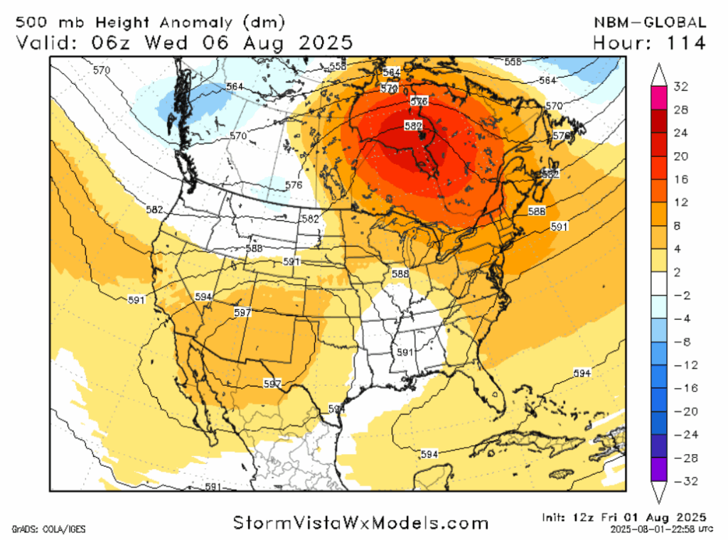
Going into Wednesday, the pattern will shift again. The cold front and trough will dissipate. All signs point to our area being in the middle of two ridges. Without getting too deep into the weeds, this pattern signals “normal” weather, with highs in the low 90s and the chance of an afternoon thunderstorm between 30 and 40%.
Near the end of the week, the ridges are expected to intensify. Very warm times are in store for the Northeastern U.S. and the Interior West, where the ridges are centered. That will rub off a little bit on our area. By next weekend, highs in the mid to even upper 90s are possible. More diurnal heating could also lead to a higher thunderstorm chance.
A LOOK AT THE TROPICS
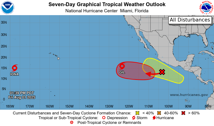
The Atlantic basin is currently quiet. There are some whispers among models of a storm forming off the U.S. East Coast, the Eastern Gulf of Mexico, or to the east of the Caribbean, but that isn’t especially likely. In the Pacific, on the other hand, there are two active tropical storms. Iona is harmlessly churning well west of Hawaii, while Gil could potentially bring some rain and gusty winds to Hawaii late next week. Two other areas of interest are in place southwest of Mexico as well. Land impacts are possible with the system associated with the yellow area, but the storm center should remain off shore. The periphery of a storm if it forms could bring flooding and mudslides to the area.
DAY-TO-DAY REGIONAL FORECAST
Today: Afternoon showers and thunderstorms likely. Highs around 90. Chance of rain 70%. North wind around 5 mph in the afternoon.
Tonight: Residual showers possible early this evening. Lows in the mid 70s. Chance of rain 40%.
Sunday: Mostly cloudy, chance of an afternoon thunderstorm. Highs around 90. Chance of rain 50%. Winds light and variable. Lows in the mid 70s.
Monday: Mostly cloudy, afternoon thunderstorms likely. Highs around 90. Chance of rain 60%. Lows in the mid 70s.
Tuesday: Mostly cloudy, afternoon thunderstorms likely. Highs around 90. Chance of rain 60%. Lows in the mid 70s.
Wednesday: Partly cloudy, chance of an afternoon thunderstorm. Highs in the low 90s. Chance of rain 40%. Lows in the mid 70s.
Thursday: Partly cloudy, chance of an afternoon thunderstorm. Highs in the low 90s. Chance of rain 30%. Lows in the mid 70s.
Friday: Partly cloudy, chance of an afternoon thunderstorm. Highs in the low 90s. Chance of rain 30%. Lows in the mid 70s.
Saturday: Partly cloudy, chance of an afternoon thunderstorm. Highs in the mid 90s. Chance of rain 40%. Lows in the high 70s.
Sunday: Partly cloudy, chance of an afternoon thunderstorm. Highs in the mid 90s. Chance of rain 40%. Lows in the high 70s.
Monday: Mostly sunny. Highs in the mid 90s. Chance of rain 20%. Lows in the mid 70s.


