If you are here for the Hype Train, you’re on the wrong platform. This is going to be a level-headed and realistic approach to the chance for snow along the Gulf Coast this weekend. If you want hyperbole, you’ll have to click over to somewhere else….
Looking at the general setup across model guidance for Sunday morning, we will have either “cold air in place and abundant Gulf moisture” or we will have “cold air and no moisture at all”
So we have a bit of a three-headed monster here:
— Will the air be cold enough for any wintry weather at the surface?
— Will there be a “secondary” shot of precip at all?
— Will said secondary shot of precip arrive with said cold air in place?
Well, we have those things, plus My patented guide to figuring out if it will actually snow or not in the region:
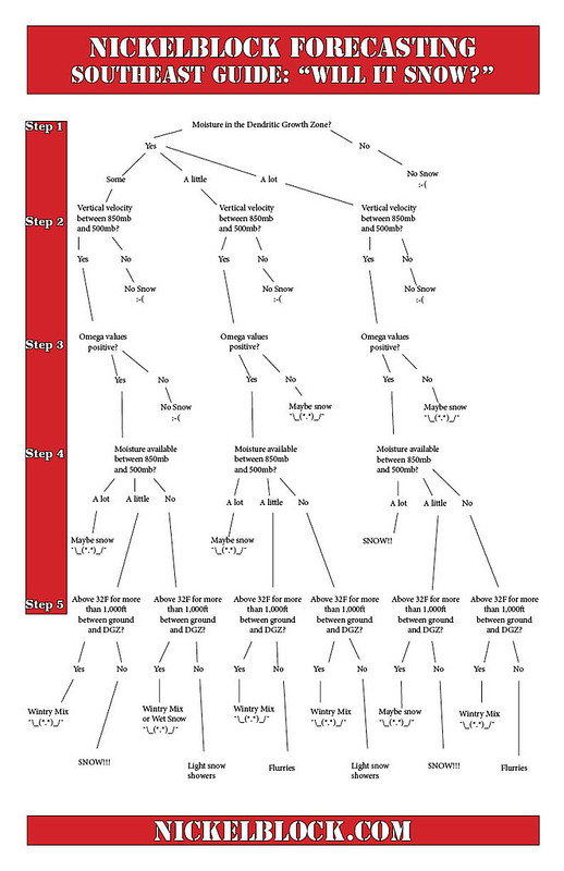
That means, it will either snow or it won’t. #BREAKINGNEWS, I know. But hang with me and allow me to explain. And I’m going to try to do it without showing a single “snowfall totals” map. Because, right now, in all honesty here: They’re all hot garbage.
COLD AIR COMETH…. EVENTUALLY
We will have a cold front swing through the area on Saturday. It’ll bring a brief shot for some rain, nothing major, and then scoot on out of here. Behind the rain, the cold air will start to ooze southward. And by midnight Saturday night and into Sunday morning, we should be down around 35F to 40F.

But the temperature spread across model guidance is pretty wide right now. Some shows temperatures in the low to mid 30s. Others show it near 40F and some are close to 45F.
And when we have more moisture potentially on the way, that 10-degree temperature difference is a BIG deal. It is the difference between a cold drizzle and wintry precip.
OFten times, this time of year, “Global” models like the GFS and ECMWF struggle with how quickly the cold air behind cold fronts move. They also struggle to resolve the composition of the air itself — is it humid? Is it drier? What does the vertical column of air look like? Is there any remnant forcing? So many unknowns.
What we need to do is look at shorter-range guidance for a better idea about what the post-frontal airmass might look like.
SHORTER-RANGE GUIDANCE
Looking at the shorter-range stuff, on paper, is useful. But right now, it isn’t because the shorter-range guidance could not be any more at odds.
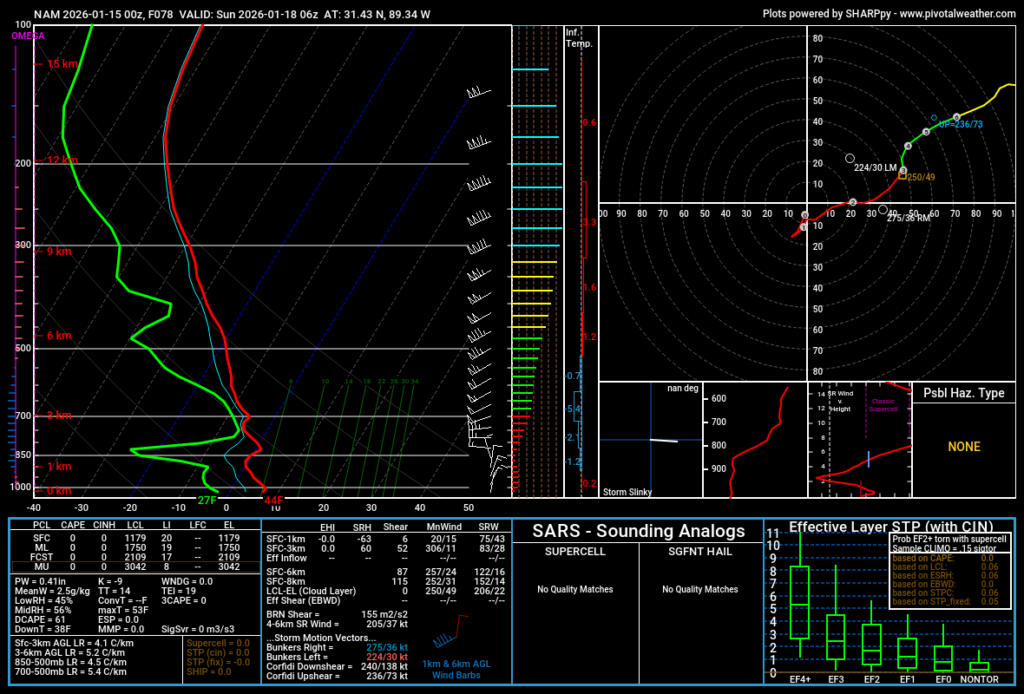
— The NAM model (above left) shows warm, dry air in place when the secondary shot of precip arrives.
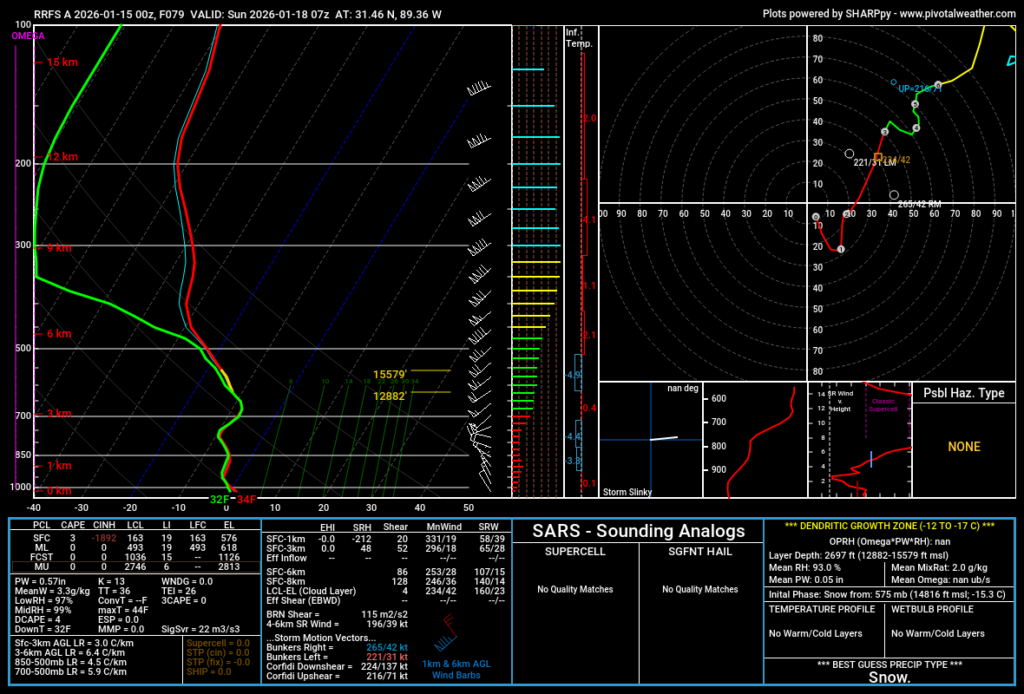
— The RRFS shows cold, humid air in place when the second round of precip arrives.
So, one of these shows snow, the other one shows some chilly mist and drizzle.
No help there…. Well, maybe some help, but I’ll get to that shortly.
THE ELBOW
Long-time readers of this website/app as well as folks who used to watch me on TV probably remember me talking about “the elbow” we need to see on the 500mb maps for us to get a good “over-running” snowfall event.
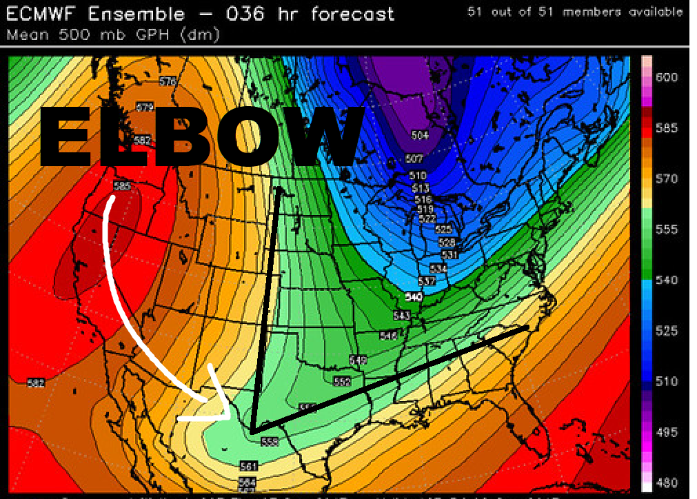
In fact, it was almost one year ago, to the date, that I was talking about “The Elbow” and snow potentials. And we got a lot of snow oin some spots.
Looking at this setup vs. last years BIG snow event, we can see some serious structural differences.

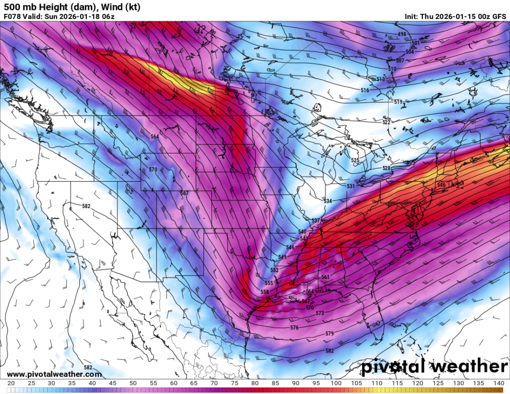
The first map (left) from last year shows the elbow pretty prominently. This year, it is lass of an elbow and more of a gardening trowel. That may limit how far north some of the Gulf moisture can make it ahead of the second wave of precip. It also means the length of time we would be in the “Sweet spot” for precip will be shorter.
But this is “big picture” stuff, so we really need to look under the hood, too.
UNDER THAT HOOD
Let’s go back to the NAM model. The one that previously showed a Skew-T of “a cold drizzle” above.
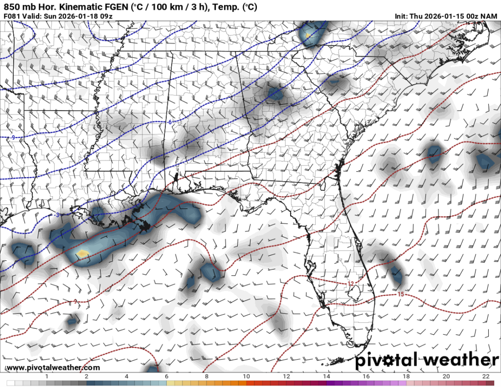
What we can see regionally is a fair bit of mid-level moisture sitting on top of a bit of frontal action (what I usually call “umph”) happening beneath it.
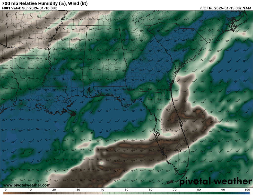
That is the “secondary shot for precip” we are looking for. It is just a bit harder to see on the NAM than on the RRFS.
That is to say, the same setup is shown (with a bit more ferocity) on the RRFS model, too. So much sno that it is producing soundings that re tip-toeing close to Thundersleet (the most Metal sounding weather you can get) and Thundersnow
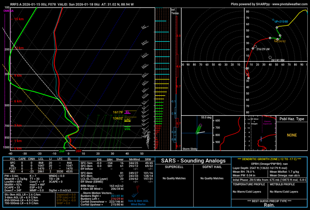
But it would be a very quick burst of precip. We are talking about two to three hours of precipitation. And it would likely start as rain for many folks. So the longer it remains rainfall, the less snow there is to see.
And, this far out, we simply can’t know for certain how long things will stay rain vs. switch to snow.
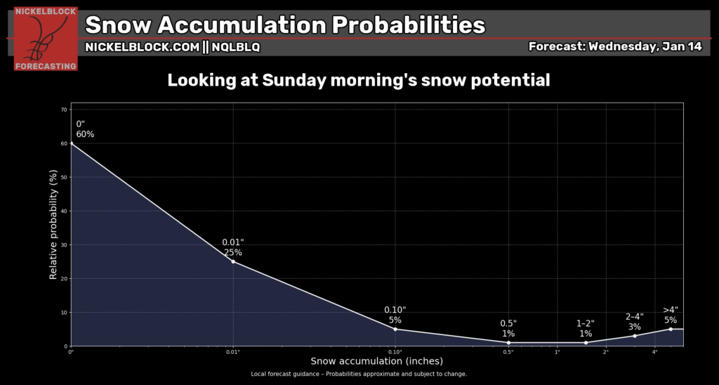
BOTTOM LINE
Because we can’t know for certain, we can produce ranges of possible outcomes givent he statistics at play.
I want to note here, that I am currently “under-forecasting” the potential for a secondary shot for precip because I have some serious questions about how well any model is handling it at this time.
So, if we do see a change to my forecast, it is more likely to change toward “more snow” than “less snow” in the coming days. But for now, this is where I sit:
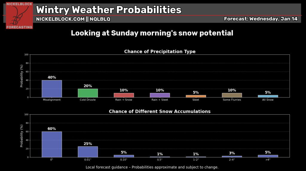
I think teh best bet is for nothing to happen at all or we see a cold drizzle. Because again, I ahve quesiton s about the over-running moisture and cold air combo.
But if we do see snow, I think the likelihood of snow totals it weighted toward the edges. We will either see nothing or we will see meaningful accumulating snow (greater than 2″ in some spots). After looking over the data, I think an outcome of a “dusting” or “less than 1″ of snow” is less likely than “more than 2″ of snow” — hopefully that makes sense.
As for the timeline, I think this is going to be a pre-dawn event on Sunday. If we do see snow, it would be most likely between about 2am and 7am.
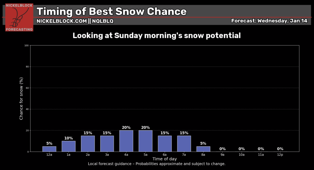
But again, I want to stress, that we “peak” currently at just a 20$ chance that you see snowflakes. Not that you see accumulations.
I know everyone wants to know, “How much snow will I get?” but that isn’t possible to know yet. A computer weather model can give you a number, sure. But that number isn’t worth the screen it is shown on. We are still too far out to know how much snow may fall. Because we still don;t know if we will even have enough moisture to make any kind of precipitation… let alone knowing if it will or won’t be snow. And if so, for how long. And where.
…. well, you get the idea.
Hang in there. I think we will learn a bit more during the next 24-48 hours. And I tend to think (despite all of this uncertainty and back and forth) that this event will be easier to forecast than most snowfall events. Because we will either have all of our ingredient, or we won’t this time.


