I want to start with what we do know. We do know that some parts of the area are going to be dealing with some nasty winter weather – including freezing rain and sleet.
I put goether a quick infographic to explain visually.
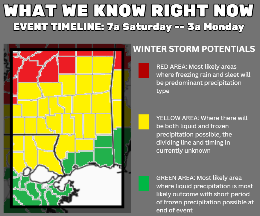
We expect this to be a “longer” event. This won’t blow through in a few hours. It will end up lingering through most of the day on Saturday (depending on your location) and most of the day on Sunday (again, depending on your location) and into early Monday morning (location dependent).
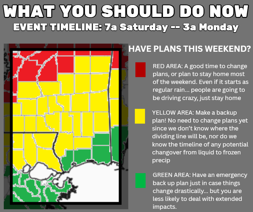
I have heard from a number of folks with plans this weekend asking about changing plans given the forecast. And I can’t tell anyone living south of I-20 to “change plans” yet. I think it is a really, really good idea to have a backup plan, though.
Right now, if you live in the yellow area, we just simply don’t know which counties will deal with freezing rain, which one will get sleet and which one will get a cold rain. There is a better chance if you live farther north that it is frozen… but the dividing line is going to be very, very sharp between folks who see nothing but cold rain, the folks that see a cold rain switch to freezing rain and sleet, and those who got all freezing rain or sleet the entire time. Like, as little as 10-20 miles in some spots.
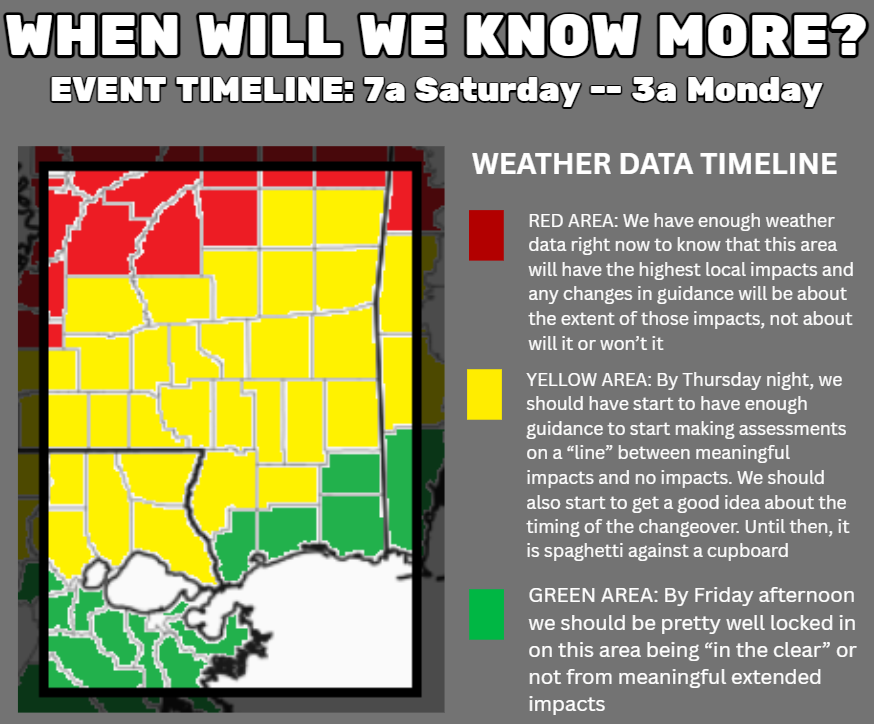
With each next model run, we get an idea about how things will shake out. Not because on Thursday night a special model will magically know everything. But rather, we will have enough of a collection of information, across a bunch of models during a handful of days, to start making assessments about the probability of given outcomes.
Forecasting this kind of wintry precip is never simple. It is straightforward, but it is not simple. I liken it to replacing a clutch in an old car. The job is straightforward — just unbolt the bad one and bolt on the new one — but there are a lot of moving parts and often you have to do two (or more) things at once.
In our case, with weather, we just need to tell you if it is going to be icy or not. But there is precip over here and cold air over there and forcing in the middle and we need to make sure it all lines up in the right way at the right time for that to happen. And figuring that out is….. not easy.
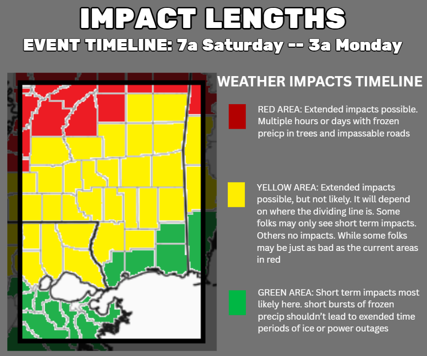
The other important note here is that there is a BIG difference in these events between folks who see extended impacts and the ones who see short term impacts.

For example, in the green areas, you may still get an hour of sleet. But the temperatures should remain above freezing while it is precipitating, so impacts should be confined to a short period of time. Maybe an hour or two. Maybe three.
Doesn’t mean you are “in the clear” completely. Just that, when it happens, if you just hang tight for a few hours, you’ll be fine.
While folks dealing with extended impacts can expect to deal with freezing rain and sleet for a while. More than 6 hours and impacts that last more than 12 hours. Perhaps a few days. So if you live somewhere that is expecting extended impacts, prepare for being without power or unable to travel for a day or two. Maybe even three.


I have always wondered…What is the difference in freezing rain and sleet?
That’s an excellent question
That’s a great idea for a post! …. That’ll be next on the to-do list!
Nick,
Hi, from the Pine Belt! Thanks for the heads-up, these guys here are keeping us in the loop as well. It’s been just plain COLD. 27 , MAYBE 28F just outside Petal, MS. Brrrr!