Welp, its the first one of the season: a Marginal Risk for severe weather from the Storm Prediction Center. If you’re new to these parts, the Storm Prediction Center (SPC) tallies severe risk on a 1-to-5 scale with a “5” indicating the highest risk for the most significant severe weather. The SPC also notates the list with words. The list is Marginal (1), Slight (2), Enhanced (3), Moderate (4), and High (5).
So, we are at a “1” on the 1-to-5 scale. The slight Risk is back to the northwest.
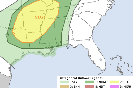
But that “1” in this case may actually feature a slightly higher risk that may need to get bumped up a tad in the coming updates tonight or tomorrow.
A QUICK NOTE ABOUT TORNADO RISKS
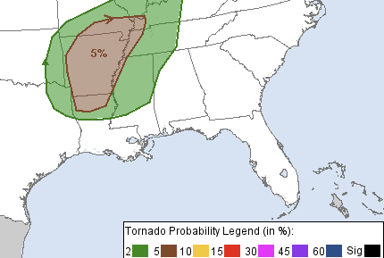
The SPC also shows a 2-percent tornado risk. I know what you’re thinking, “TWO percent?! Whoo hoo! No tornadoes!” But, sadly, statistically, this percentage doesn’t work like looking at the chance for rain. Or a chance to get a date with your celebrity crush (probably also at a 2% chance!).
Instead, we use this as a comparison to the daily risk – on any given day – that a tornado may happen. So, we would say, on any given October 18th, what is the chance a tornado occurs? It turns out there is a less than 1% chance on any given day (irrespective of the weather) that a tornado happens.
So a 2% chance means you are at least twice as likely to see a tornado tomorrow than any given day.
THE SETUP
We have a little system set to swing through and it should usher in some cooler air. But the collision of that cooler air down at the surface witht he warmer, humid air that is in place means we will spark off some showers and storms.
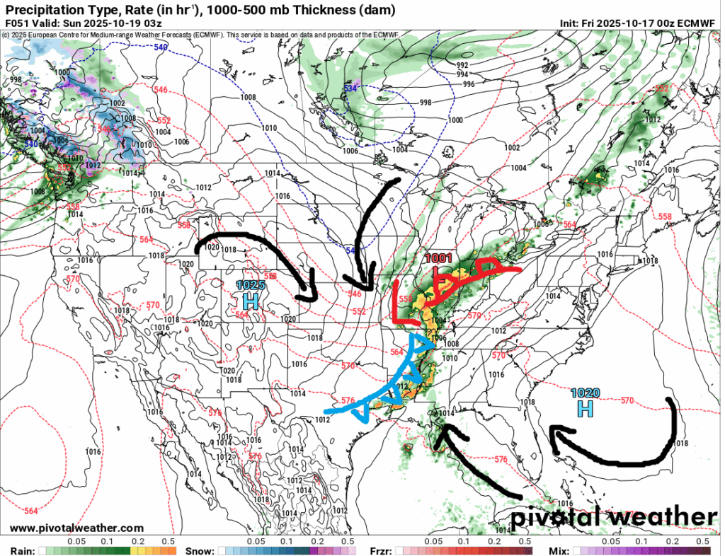
The area of low pressure should push a cold front through the area late Saturday night and into Sunday morning. Ahead of it, the black arrows show the warmer air being pulled north from the Gulf and open Atlantic. And the other black arrows to the north show the direction the air is coming in from the Great Plains and Canada.
The interesting part about this setup is that, a bit like a lot of our “Cold season” events, ti will be very CAPE-dependent. That means we will have to wait and see just how much instability we have in place as the line rolls through.
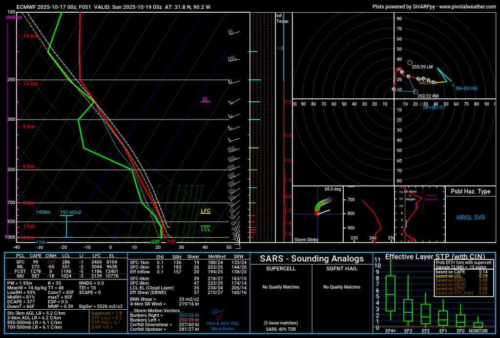
Forecast model guidance skew-t charts show a reasonable amount of shear and helicity in place. Plus a surface-based Effective Inflow Layer. So, if we have any instability, we have a surface-based inflow section that has winds turning with elevation to promote the development of rotating updrafts that could get rooted at the surface.
That’s fancy weather talk for: ‘Nader Makers.
So far, most model guidance has been pretty relaxed on how much instability we will have in place, and that is limiting the risk for severe weather. But some ensemble guidance has shown a bit more instability in recent runs, so it may prompt the SPC to increase the Severe Weather Risk to Slight Risk for a larger portion of the area.
THE FORECAST
So far, as mentioned above, there isn’t a bit risk for significant severe weather. In fact, even if we do get bumped up to a Slight Risk, I don’t know that it would change the “forecast” much.
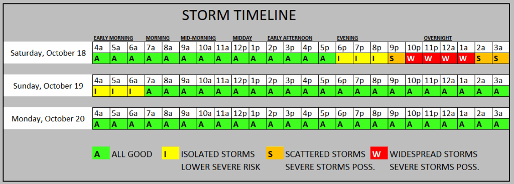
The timeline suggests that most storms will be between about 9p and 3a. I think a handful of storms may be isolated on the front-end of the event Saturday night. And we may have a few that try to linger around into the early pre-dawn hours, too.
I think the forecast for severe weather threats looks like this:
EVERYONE – A brief round of rain, lightning and thunder with a wind gust up to 25mph
MOST PLACES – A brief round of heavy rain, lightning and thunder, one or two wind gusts up to 35mph
MANY FOLKS – A brief round of heavy rain, lightning and thunder, a few wind gusts up to 45mph
SOME SPOTS – A brief round of heavy rain, brief localized flooding of roads, lightning and thunder, a number of wind gusts up to 55mph
A FEW LOCATIONS – A few rounds of heavy rain, frequent lightning, wind gusts up to 65mph, and a brief tornado
We will probably see a handful of severe thunderstorm warnings issued and maybe a few tornado warnings, too.
THE BOTTOM LINE
This Saturday night and into Sunday morning… Storms will be possible, rain is likely. Severe weather can’t be ruled out. And a tornado ro two is possible, too.
I want to stress, though, that this is not an “a-typical” tornado-making event. Nor does this have “strong tornado” potential. This is just a run-of-the-mill Gulf Coast severe weather setup. The kind we will see a good dozen times this Winter. Maybe more.
But it is the first one we have seen since, like, May. So it has been a while! A good refresher as we make our way into our secondary severe weather season from Oct 15th through Nov 30th.


