
Starting off today and tomorrow, the rain has cleared out of Mississippi and will pass through the rest of the afternoon into the evening time. Behind it, a much cooler airmass will enter the deep south with cool and dry weather for the next several days. A strong high pressure system will move east from the southern plains which will bring with it more northerly winds. Temperatures during the day will slowly build up from the low 50s to the 60s by midweek. Expect winds to gust up to 25 mph on top of the cooler temperatures. On the flipside, low temperatures may reach the low 30s and even the upper 20s at night. If you have older pipes or plants you want to keep from getting frost, this week will be the week to put some protective equipment over them.
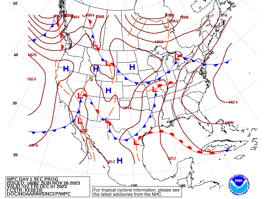
By Wednesday and Thursday, we’ll see a shift of the winds to the south thanks to a prevailing warm front out in the Gulf. The ridge will begin to weaken and give way to another cold front. This one will be fairly slow moving and bring with it quite a bit of rain if the setup looks similar in the next several runs of the models. So far, the models are showing possibly three shortwaves that would bring rain and possible thunderstorms to the deep south.
Just to preface this, we’re still waiting on model guidance to agree on what may happen this weekend. While the first couple of rounds of rain don’t look as threatening, the last couple of systems may develop into some thunderstorms with heavy rain as temperatures and dewpoints begin to climb. Not only this, Louisiana and Mississippi both look to get some significant rain out of the deal (around 3-5 inches!) if there are so many rounds of storms developing. With the warm front developing so close to the gulf coast, it wouldn’t surprise me that we’ll see some heavy rain with this system. By Sunday night, the cold front looks to organize and make a move on to the east as it develops over the Great Lakes.
Have a good week and prep for the colder and rainier conditions!
[wpcode id=”41179″]
Regional Day-to-Day Forecast
This Afternoon – Partly sunny, with a high near 62. North northwest wind around 5 mph.
Tonight – Partly cloudy, with a low around 36. North northwest wind 5 to 10 mph.
Monday – Areas of frost before sunrise. Otherwise, mostly sunny, with a high near 54. North wind 5 to 10 mph.
Monday Night – Widespread frost after midnight. Otherwise, mostly cloudy, with a low around 31. North northwest wind around 5 mph.
Tuesday – Widespread frost before sunrise. Otherwise, sunny, with a high near 57. North northeast wind around 5 mph.
Tuesday Night – Patchy fog after midnight. Widespread frost, mainly after midnight. Otherwise, mostly clear, with a low around 28. Calm wind.
Wednesday – Patchy fog and widespread frost before sunrise. Otherwise, mostly sunny, with a high near 61. Calm wind becoming south around 5 mph.
Wednesday Night – Partly cloudy, with a low around 35. Calm wind.
Thursday – Partly sunny, with a high near 66. Light east southeast wind becoming southeast 5 to 10 mph in the morning.
Thursday Night – A chance of showers, with thunderstorms also possible after midnight. Mostly cloudy, with a low around 54. Chance of precipitation is 50%.
Friday – Showers likely and possibly a thunderstorm. Cloudy, with a high near 71. Chance of precipitation is 70%.
Friday Night – A 50 percent chance of showers. Mostly cloudy, with a low around 57.
Saturday – A 50 percent chance of showers. Mostly cloudy, with a high near 68.
[wpcode id=”41149″]


