The Storm Prediction Center continues to monitor the region of the potential for severe weather. Latest model guidance continues to show the threat for storms and very – very! – heavy rainfall across the area during the day on Wednesday.
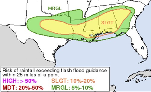
The SPC has expanded the Slight Risk area to include a larger portion of South Mississippi.

But, it isn’t – necessarily – an increase tornado threat the SPC is concerned about. It is hail.
From the SPC
Here is the latest from the SPC:
Continued large-scale forcing for ascent attendant to the approaching upper low is expected to support widespread showers and thunderstorms from northwest TX into northern LA early Wednesday morning. Thunderstorms will also be ongoing near the surface low, augmented by more mesoscale/localized ascent associated with the surface low and convergence along the front. General expectation is for the surface low to move eastward across southeast TX, southern LA to coastal MS/AL. The widespread showers and embedded thunderstorms will also move east over the Lower MS Valley and Southeast states.
Much of the thunderstorm activity will take place well north of the front amidst a messy multicellular storm mode. Isolated hail is possible within any of the stronger, more persistent storms. Storms near the surface low and front will benefit from the augmented forcing for ascent. As a result, these storms could be more intense and capable of severe hail and damaging wind gusts. A predominately multicellular storm mode is anticipated here as well. This messy mode introduces some uncertainty regarding storm organization, but the strength of the shear suggests some organized bowing line segments are possible. These storms would promote a relatively higher risk of strong downdraft wind gusts as well as embedded tornadoes.
Despite a favorable environment, the limited inland extent of the warm sector will result in low confidence for discrete warm sector development. Even so, a strengthening low-level jet will contribute to increase warm-air advection and the non-zero chance that one or two of these storms may be able to establish within the boundary layer. Veering low-level wind profiles and strong deep-layer shear support a tornado threat with discrete warm-sector development.
Remember that late February through middle April is our “hail season” so a threat for hail isn’t out of the question. Model guidance is showing the potential for rotating updrafts within some elevated storms during the day on Wednesday.
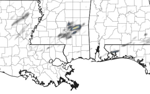
That is a look at some of the Updraft helicity streaks from the HRRR model. The image was pulled from data around noon. These storms would not be surfaced-based. That means the tornado threat would be basically zero. But the rotating storms will still be able to produce hail. And in a strong enough updraft, hail up to the size of quarters or half-dollars.
Flooding risk
There is still the potential for flooding, too. The Weather Prediction Center still has the area under a Slight Risk for flash flooding. Here is the latest from the WPC:
04Z Update: The threat of flash flooding continues across portions of TX/LA and into the Deep South as strong low level moisture convergence, instability and upper level divergence overlap ahead of a closed mid-level low. Moisture profiles will be impressive as well illustrating a low level connection to the Gulf and a mid/upper level connection to the subtropical Pacific. This certainly seems like a setup where at least localized rainfall exceeding 4″ with a broad area of 2-4″. With that said, uncertainty remains in regard to the exact evolution of this system, the frontal placement and the exact track of the apparent low. Thus a lot of spread continues with respect to the heaviest rainfall axis. In addition, there is also uncertainty on how much overlap we see between the max rainfall axis and the portions of MS/AL/GA that have seen monthly rainfall departures of 200%+. Even though the environmental ingredients may support a Moderate risk, given the above uncertainties, maintained and refined the broad Slight risk area for now. If model agreement increases, and there is overlap of this heavy rain with the aforementioned saturated areas, then a Moderate risk upgrade may very well be needed.
It still looks like 2″ to 4″ of rain will be possible with some spots picking up as much as 6″ of rain. Here is a look at one of the models:

The ECMWF shows a swatch of 2″ to 4″ with a few blotches of more than 5″ of rain. Figuring out exactly who sees how much rain, though, is still not a thing we can do, sadly.
The Bottom Line
Severe weather still looks possible for tomorrow. Flooding still looks possible for tomorrow. Storms will being in the morning and be on and off all day as the front flops around in the area.
More details will be posted later!


