We’re enjoying a calm and pleasant stretch of weather for now, with highs in the upper 80s and low 90s and lows in the 60s and 70s. But changes are on the horizon. More rain (and storms) are headed our way.
As dry as it has been, this should help perk up the plants a bit, but it will come with the risk for heavy rain, lightning, gusty wind and hail. The tornado threat should remain low.
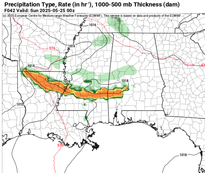
As we head into the weekend, a shift in the weather pattern will bring moisture back into the region, increasing the chance for rain and storms—especially from Friday night through early next week. And the other piece of the puzzle is the northwest flow that is going to set up overhead.
Normally in the Fall, Winter and Spring a northwest flow is a drier flow for us. But in late Spring and Summer, it means we get a chance for storms to come barreling through from the Plains. And, in this case, a remnant MCS (Mesoscale Convective System) may drift in on Friday night and into Saturday.
What is an MCS?
When we talk about thunderstorms, we often think of a single storm cell—maybe the one that rumbled through your neighborhood and dropped some heavy rain. But sometimes, individual thunderstorms link up and behave like a team. That’s what we call a Mesoscale Convective System, or MCS.
Think of an MCS as a storm system made up of many thunderstorms working together. These systems are bigger than any one storm and can last for hours—even overnight. They often stretch across entire states and are responsible for a wide variety of weather impacts: heavy rain, flash flooding, hail, damaging winds, and even tornadoes.
On radar, an MCS might look like a line (called a squall line), a big circular cluster (called a Mesoscale Convective Complex, or MCC), or a messy blob of cells. Regardless of the shape, what sets an MCS apart is how organized it is and how long it sticks around.
Some MCSs can be especially intense. For example:
- A derecho is a type of MCS known for producing widespread, straight-line wind damage over hundreds of miles.
- An MCV (Mesoscale Convective Vortex) is a swirling low-pressure center that can spin off from an MCS and even lead to new storms later on—sometimes even helping to kickstart tropical systems if it moves over warm water.
In short, an MCS isn’t just a single storm or a group of storms, it is more of a storm machine. And it can evolve, persist, and impact large areas. When one shows up in the forecast, it’s worth paying attention.
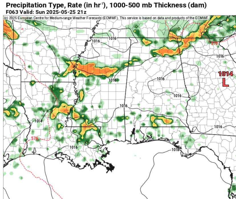
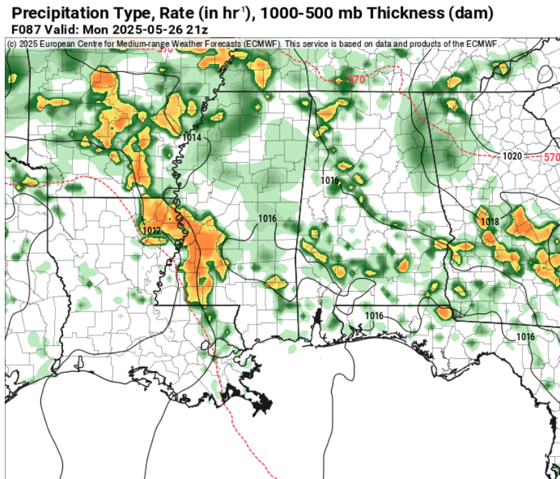
Then we may have another one Sunday night into Monday morning. Then perhaps another Monday night and into Tuesday.
That timeline is based on the math. But if you look at the computer weather model guidance for rainfall, it shows these storms showing up a bit earlier in the day. On Saturday evening, one Sunday afternoon, and the next Monday afternoon.
So things may get a bit active. And slightly uncertain.
Looking at some of the AI-assisted guidance for the chance for storms (not just when it will be raining, but when there may be storms) it looks like we have a good number of chances during the next 10 days.
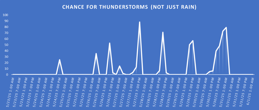
That means, it you are planning a trip for the three-day weekend to go camping, or just have a backyard BBQ with the neighbors, you’ll want to keep the NickelBlock Forecasting app handy
I wouldn’t cancel plans. But I would definitely – seriously! – make a backup plan if I had any outdoor activities planned for this weekend. These storms will have a fair bit of lightning in them, so you aren’t going to want to be outside standing next to a grill or inside a tent as they pass.
Notice this riff-raff lasts nearly all of next week. This means we will hold on to a chance for rain a bit longer than we were thinking 24 hours ago. So hang in there.
REGIONAL DAY TO DAY FORECAST
Today: Sunny. Highs in the lower 90s. North winds around 5 mph, becoming south this afternoon.
Tonight: Mostly clear. Patchy fog after midnight. Lows around 70. South winds around 5 mph in the evening, becoming light and variable.
Saturday: Mostly sunny. A slight chance of showers and thunderstorms in the afternoon. Highs in the lower 90s. South winds 5 to 10 mph. Chance of rain 20 percent.
Saturday Night: Partly cloudy in the evening, then becoming mostly clear. Lows in the lower 70s. South winds 5 to 10 mph.
Sunday: Mostly sunny. A slight chance of showers and thunderstorms in the afternoon. Highs in the lower 90s. South winds 5 to 10 mph. Chance of rain 40 percent.
Sunday Night: Partly cloudy. A slight chance of showers and thunderstorms in the evening. Lows in the lower 70s. Chance of rain 20 percent.
Memorial Day: Partly sunny. A slight chance of showers in the morning, then a chance of showers and thunderstorms in the afternoon. Highs in the upper 80s. Chance of rain 40 percent.
Monday Night: Mostly cloudy. A chance of showers and thunderstorms, mainly in the evening. Lows in the lower 70s. Chance of rain 40 percent.
Tuesday: Partly sunny. A chance of showers with a slight chance of thunderstorms in the morning, then showers likely with a chance of thunderstorms in the afternoon. Highs in the upper 80s. Chance of rain 60 percent.
Tuesday Night: Mostly cloudy. A chance of showers and thunderstorms, mainly in the evening. Lows around 70. Chance of rain 20 percent.
Wednesday: Partly sunny with a chance of thunderstorms. A chance of showers in the morning, then showers likely in the afternoon. Highs in the upper 80s. Chance of rain 40 percent.
Wednesday Night: Mostly cloudy with a slight chance of showers and thunderstorms. Lows around 70. Chance of rain 10 percent.
Thursday: Partly sunny with a chance of showers and thunderstorms. Highs in the upper 80s. Chance of rain 40 percent.
15-DAY OUTLOOK
This is our AI-assisted outlook. This is not produced by a human, but rather by NQLBOT, our AI weather helper. Do know it may lack the specific accuracy of a real forecast, but should help to give you an early heads up on the potential weather.


Nice to see someone showing not just WHAT the weather will be doing but also WHY. Seems to be a common theme with rain … it tends to ALWAYS over-stay its welcome.