After a week filled with unsettled weather, a cold front will move through on Friday, initially bringing one last round of storms, will finally allow for some favorable weather this weekend, with comfortable humidity levels, average temperatures, and clear skies.
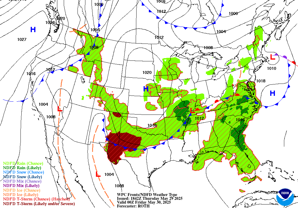
This week’s setup has made for some very irritating weather. Perhaps a friend or colleague of yours has said something like “The weather doesn’t know what it wants to do today”! Well that tends to happen when you have a setup like the one we’ve had this week. We’ve had a low pressure system over the tri-point of Arkansas, Missouri, and Tennessee, with a stationary front connected to it keeping the low pressure basically locked in place.
The low pressure has been rotating in tropical air from the Gulf all week, which interact with shortwaves to produce round after round of rain. This stationary front stretches due east, while the aforementioned cold front is slowly rotating around our low pressure, and is currently moving through Arkansas.
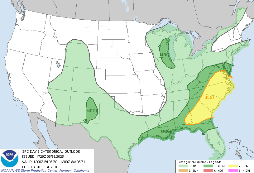
This cold front will act as a lifting mechanism. which, due to our moist environment, could be a trigger for some severe thunderstorms. These storms will move from the northwest to the southeast, starting in central Mississippi shortly after lunchtime, moving quickly through the region, exiting coastal Alabama around dinnertime. The Storm Prediction Center (SPC) has put up a marginal risk of severe weather, which is the lowest risk category.
The threat is conditional, there is a world where the storms stay below severe limits, perhaps due to morning cloud cover stopping the atmosphere from getting too unstable. The SPC lists the chance of severe wind (above 58 mph) or severe hail (above 1 inch in diameter) as 5% within 25 miles of a given area. In other words, if your house is near the intersection of four counties or parishes, there is a 5% chance of a severe wind event happening somewhere in one of those counties/parishes, and a 5% chance of the same thing but for hail. A lack of near-surface level shear and convective inhibition means that tornadoes are not likely, but perhaps a brief embedded spin up within a line of storms is possible. There will be plenty of instability for the atmosphere to work with to produce thunderstorms with damaging winds, especially in a squall line, or hail cores in any discrete thunderstorms.
Heed the advice of the National Weather Service – when thunder roars, go indoors. If a severe thunderstorm warning is issued, take extra care. Make sure loose outdoor objects are secured so they aren’t blown away.
A Break this Weekend

Saturday and Sunday both promise to be much better. In the wake of the cold front on Friday, dew point temperatures will decrease dramatically, in some cases by 15 degrees or more compared to Friday. While it will be warm on Saturday with temperatures in the high 70s and low 80s, at least it will be a dry warmth. A slight northern breeze will add to the refreshing day.
As the cold front gets further away, it will get warmer by a few degrees on Sunday, but it will still be pleasant. More clouds may enter the area providing shade.
Looking Ahead to Next Week
Moving towards next week, the first part of the week will continue to be pleasant. There is a slight chance of rain early Monday from a shortwave, but besides that, we’ll have a ridge over the western United States that will advect in cooler drier air from the Plains. But as that ridge moves over our area late in the work week, we will revert to a muggier setup, where pressure systems will blow up air from the gulf. Apparent temperatures could approach 100 degrees, especially in Louisiana, and another shortwave or other lifting mechanism could induce thunderstorms.
Watching the Tropics
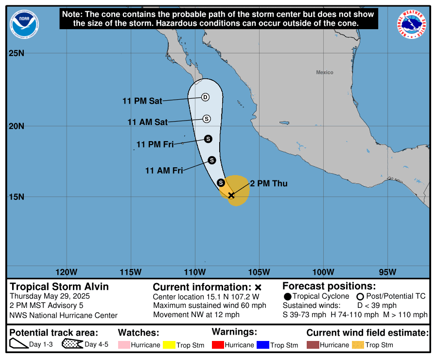
We have our first storm of the system, Tropical Storm Alvin, off the Pacific coast of Mexico. This storm will move north towards Baja California, but will likely weaken to a Tropical Depression as it moves over wind shear. Still, it’s possible that moisture from this storm may add to the mugginess in our area late next week, depending on how the setup is aligned.
[wpcode id=”41149″]
Regional Day-to-Day Forecast
Today: Mostly cloudy with a chance of showers and thunderstorms in the afternoon. Humid. A few storms may be severe. Highs in the mid 80s. West winds 5 to 10 mph. Chance of rain 70 percent.
Tonight: Mostly cloudy in the evening, then becoming partly cloudy. Lows in the lower 60s. North winds 5 to 10 mph.
Saturday: Sunny. Highs in the mid 80s. Lows in the low 60s. Northwest winds 5 to 10 mph.
Sunday: Mostly sunny. Highs in the high 80s. Lows in the mid 60s. Northwest winds 5 to 10 mph.
Monday: Partly cloudy. Highs in the high 80s. Lows in the mid 60s.
Tuesday: Partly cloudy. Highs around 90. Lows in the high 60s.
Wednesday: Partly cloudy. Showers possible. Highs in the low 90s. Lows in the high 60s. Chance of rain 30%.
Thursday: Mostly cloudy. Showers possible. Highs in the low 90s. Lows around 70. Chance of rain 60%.
Friday: Mostly cloudy. Showers possible. Highs in the low 90s. Lows around 70. Chance of rain 50%.
Saturday: Partly cloudy. Highs around 90. Lows around 70.
Sunday: Partly cloudy. Showers possible. Highs in the high 80s. Lows in the high 60s. Chance of rain 30%.


