General Central/Eastern Kansas Forecast
Short-Term (Thursday-Friday)
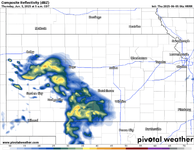
This morning, weak showers will be moving through central and eastern Kansas from a leftover system in southwest Kansas overnight last night. This activity will move off to the northeast and clear the region by 12-2pm. Later on towards the evening and overnight hours, a more robust system will march its way through and bring the potential for heavier thunderstorms, with an attendant severe threat present in south central Kansas. The main concern with this system will be heavy rainfall due to extremely high moisture concentrations in the lower/mid-atmosphere, but some large hail and damaging wind gusts can’t be ruled out either. Heightened flooding concerns may be present, especially across east-central Kansas where the heaviest rains fell on Tuesday, especially if we get any robust thunderstorms to develop. Storms will move generally east-southeast straddling the Kansas-Oklahoma border through the overnight hours.

By tomorrow, small pockets of showers will be possible throughout the day, but overall chances will be lower than with today. Overnight tomorrow night though, rain chances will increase again as heavier showers and thunderstorms will try to move through the area.

Temperatures throughout the day will reach into the mid to upper 70s across central and eastern Kansas, before dropping down to the mid 50s to low 60s overnight. By tomorrow, temperatures will again reach the mid to upper 70s, with potential for low 80s across the Kansas-Oklahoma border. Temperatures throughout the night tomorrow night will be slightly warmer, down into the low to mid 60s, with upper 60s possible in far southern Kansas. Winds throughout the day today and tomorrow will be generally light and variable.
Long-Term (Saturday-Wednesday)
Continued chances for showers and thunderstorms will persist through the weekend and early next week, before shutting down (at least temporarily) by Tuesday with high pressure building in. Temperatures will be holding steady through the long-term period being in the low to mid 80s.
Soil Moisture Update
Soils are extremely saturated after the rains from a few days ago and will continue to be so over the next day or two. Currently, all of central and eastern Kansas is sitting at 1+ inches above normal over the last week and over 5 inches above normal for the last 30 days. Flooding will continue to be a concern over the next day or two with the extremely saturated soils as water absorption will be poor.


