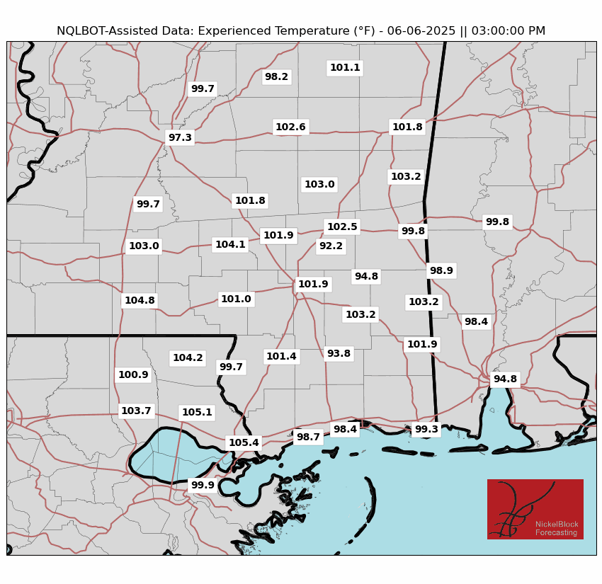
Meteorological summer is in full swing across the Southeast. Today promises to be a mostly sunny day was we’re under a nice ridge. But humidity combined with some scattered lifting does provide limited cloud cover. Temperatures will be in the low 90s, and due to that humidity, the experienced temperatures (our own internal model that more accurately depicts “feels like” temperature by factoring elements like cloud cover, wind, humidity, and dew point) will exceed 100, especially further inland where the sea breeze won’t make its presence as known. But these sunny conditions won’t last forever.
[wpcode id=”41149″]
A RISK EVERY DAY
They may end as soon as later today. Looking at the HRRR projected soundings from the Pine Belt, there is a good amount of CAPE in the atmosphere, although without much convective inhibition the storms will be more linear and less supercellular in nature. But the main issue is that surface dew point depressions (or how far below the dew point is from the actual temperature) will likely be between 15-25 degrees. That might just be too dry of an environment.
The further north and you go in the forecast area, closer to the stationary front, the closer the dew point gets to the temperature, and the likelier storms become. Due to low LCLs in these areas and the possible cluster nature of these storms, a brief spin up or two cannot be ruled out. Besides that, wind should be the primary threat.
Saturday will be a day where the whole forecast area has a better chance of seeing severe, with more moisture and wind shear aloft as a troughing pattern begins to assert itself. The primary threat besides lightning and rain will be damaging winds. Depending on how low the LCL gets, a conditional tornado threat also exists. Later afternoon into the evening is the time with the greatest severe weather risk.
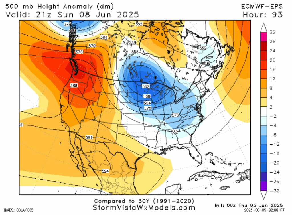
Both major models agree that a trough will descend on the area Sunday and Monday. The threat for severe weather will decrease on Sunday, as pesky “morning convection” may block the atmosphere from becoming unstable enough. Moisture and shear will be there, especially the further north you go. Sunday and Monday will be the sort of days that the severe risk comes down to if the sky is clear or not in the morning. If it’s cloudy, the atmosphere might just be too stable.
If sunbeams find grass in the morning, you may be one shortwave away from some severe weather. For those that may favor cooler weather, the trough will slowly but surely makes things cooler as it rotates in air from the north.
Many houses in this area don’t have basements, if your house is one that doesn’t and a tornado warning gets issued, go to a closet or other interior room on the lowest floor of a sturdy building. If you live in a mobile home, stay tuned to local media or a severe weather streamer so you can give yourself extra time to find a more substantial shelter if a tornado is en route.

[wpcode id=”41149″]
EXTENDED OUTLOOK
The synoptic scale of the atmosphere will be very bipolar. The trough will descend on our area most of the work week, providing some reprieve from hot temperatures, before a ridge asserts itself over pretty much the whole of the nation the following weekend, reverting our area back to a hot pattern. This back-and-forth oscillation will contribute to above average rainfall over this time period, and potentially some severe weather as well. Looking at models, the rain appears to be relentless.
Your phone weather app may show every day has a good chance of rain. In reality, what is occurring is that, since your phone is likely viewing a blend of models, one model saying a thunderstorm will specifically hit your area will throw off the forecast for the whole day. While the trough will be a moist one, and the ridge will rotate up Gulf moisture, I’m still skeptical literally every day will contain rain. But many will. Check back to this website for more details.
[wpcode id=”41149″]
DAY-BY-DAY FORECAST
Today: Highs in the low 90s. Evening severe thunderstorm possible, especially north. Chance of rain 20%.
Tonight: Lows in the mid 70s. Mostly cloudy, becoming partly cloudy.
Saturday: Highs in the mid 90s. Severe storms possible in the late afternoon or evening. Chance of rain 40%. Lows in the mid 70s.
Sunday: Highs in the low 90s. Showers possible in the morning. If no showers, severe possible later. Chance of rain 70%. Lows in the low 70s.
Monday: Highs in the low 90s. Showers possible in the morning. If no showers, severe possible later. Chance of rain 60%. Lows around 70.
Tuesday: Highs around 90. Thunder possible. Chance of rain 50%. Lows in the high 60s.
Wednesday: Highs in the high 80s. Thunder possible. Chance of rain 40%. Lows in the high 60s.
Thursday: Highs in the high 80s. Chance of rain 60%. Lows in the low 70s.
Friday: Highs around 90. Chance of rain 60%. Lows in the mid 70s.
Saturday: Highs in the low 90s. Thunder possible. Chance of rain 40%. Lows in the high 70s.
Sunday: Highs in the mid 90s. Lows in the high 70s.
Monday: Highs in the mid 90s. Lows around 80.
[wpcode id=”41149″]


