Today, we have a severe weather threat for the central plains. This moves east tomorrow and will cause major impacts along it’s path. Plus, summer will start to feel full swing for the east this weekend, as a large high pressure takes shape. Let’s take a look at all of the details:
[wpcode id=”41149″]
Today’s Overall Setup
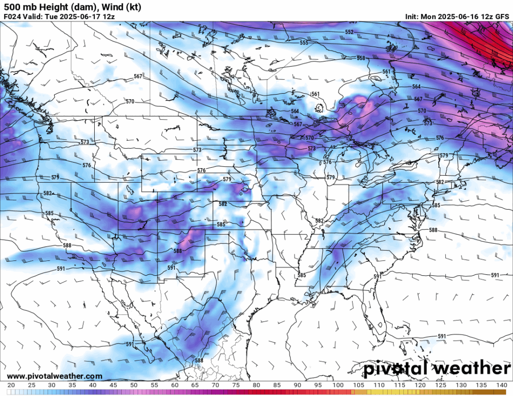

Today for the CONUS, we are looking at a very unsettled pattern that will bring unsettled weather for most of the country. A series of low pressure systems are sitting over the central and eastern parts of the country, attached by cold fronts and stationary fronts. The main culprit of the severe weather threat and flash flood threat today will be the deepening low pressure over Kansas. This will track eastward and cause a severe threat in the midwest tomorrow. While those east of the Rockies will see more rain than sun, the opposite could be said about those west of them. The west is hot and dry, and there is a critical risk of fire weather in New Mexico and Arizona, with single digit relative humidities and strong surface winds likely today.
[wpcode id=”41149″]
Today’s Severe Weather Threat
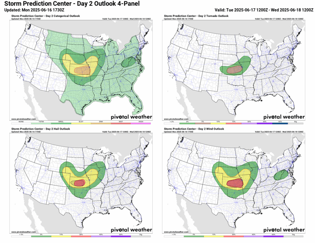
Today’s severe risk area displays a heart shape right in the heart of the CONUS. An Enhanced (3/5) risk is shaded in central/eastern Kansas and extreme western Missouri. That area, such as cities like Wichita and Kansas City, is where the SPC is most concerned with significant severe hail (hence the hatched 30 percent risk), significant severe wind gusts (30 percent hatched risk), and the chance of tornadoes (5 percent risk). Just outside the enhanced risk is a heart shaped Slight (2/5) risk for cities such as Cheyenne, Garden City, and Des Moines – where hail, severe wind, and tornadoes are possible, but less likely than the enhanced zone. Finally, outside the slight risk is a heart shaped Marginal (1/5) risk for cities like Omaha, Lincoln, Oklahoma City, Springfield, and Norfolk – where the main threat will be hail and winds.
Storms continue from Monday’s severe weather threat from the northwest down into the risk zone early today. The main line of storms, the one that poses the most severe threat, comes through the region very late tonight into early Wednesday morning. As you can see, the segment looks very intense. Severe winds, large hail, and some tornadoes are looking pretty probable with the latest model guidance. Ensure if you are in and near any of the risk areas, but especially the enhanced hatched risk areas, that you take the proper precautions to keep yourself and your property safe. Ensure your emergency alerts on your phone are on for any warnings that come through your area.
[wpcode id=”41149″]
Wednesday’s Severe Weather Threat

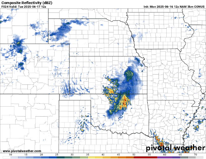
Tomorrow, the segment of storms travels to the east, and impacts a large Slight (2/5) risk zone. This includes all cities from central Oklahoma, through central/southern Missouri, most of Illinois (including Chicago), all of Indiana, parts of western Ohio, southern Michigan, and extreme southeast Wisconsin. The cold front spanning down from the low pressure will be the initiation of the convection. Dew points well into the 70s, bulk shear at around 30-40 knots, and CAPE reaching up to 4500 J/kg will allow for this cold front to develop severe storms in segments, which could be supercells.
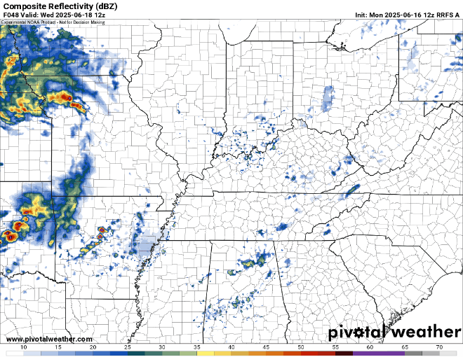
As you can see from the above modeled composite reflectivity for Wednesday, storms will push into the risk region late Wednesday evening into Thursday morning. I’d especially be concerned with large hail, damaging winds, and some tornados with this line. As we get closer, I would watch out for an Enhanced risk zone to possibly be announced, looking at some of those cells.
[wpcode id=”41149″]
CONUS Weekly Precipitation Outlook
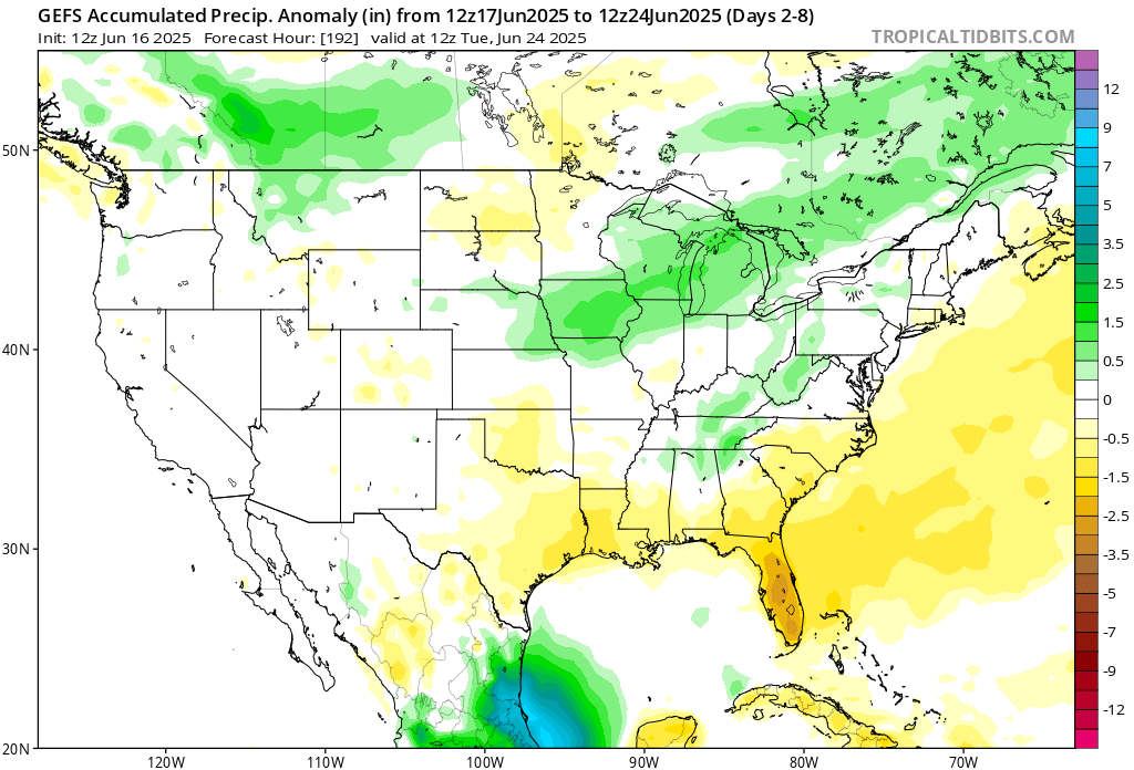
Here’s a look at the GEFS modeled precipitation anomalies through Sunday 12z. Green indicated above average precipitation, white indicated average precipitation, and yellow indicates below average precipitation. Let’s look into the details by region:
[wpcode id=”41149″]
Weekly Outlook: Western United States
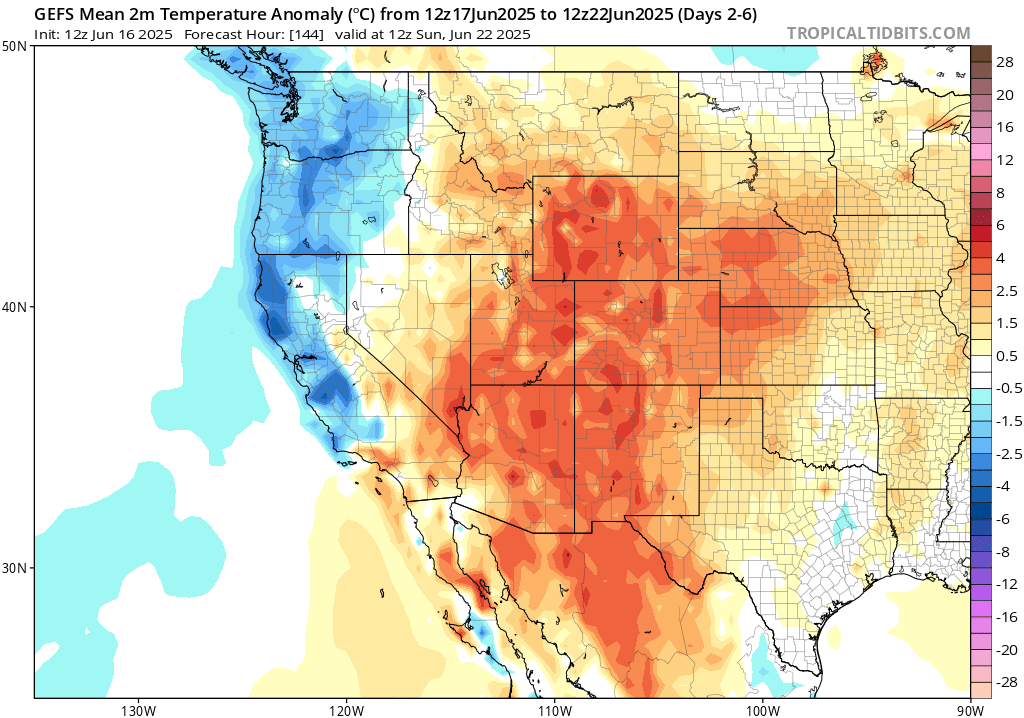
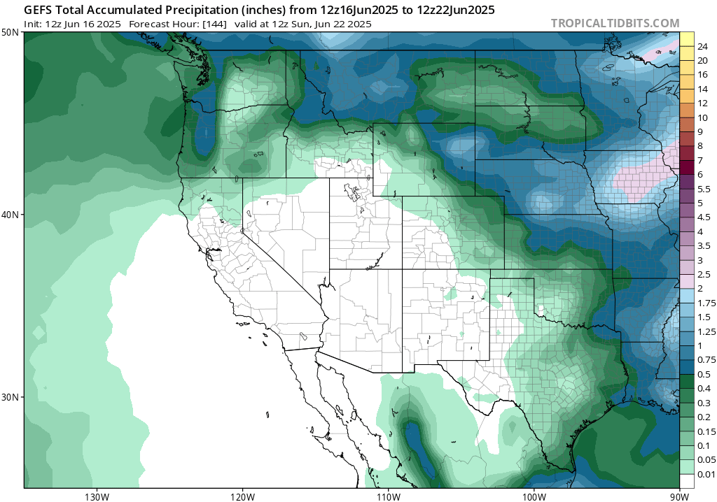
Well would you look at that! The west coast is finally trending below average for temperatures this week. A large trough will move through the region this weekend, which will keep those temperatures cooler than average. Those in the northwest will see near average total rainfall for the week, but those in California and the desert regions will not see much rain at all.
[wpcode id=”41149″]
Weekly Outlook: Central United States
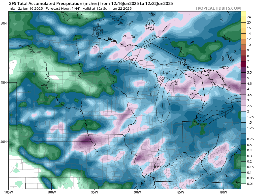
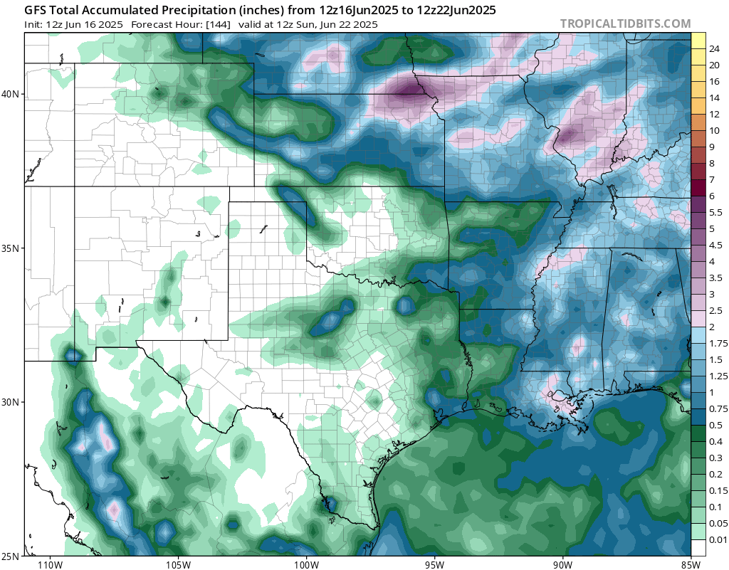
The north-central CONUS will see a good amount of rain through this week, mainly due to the multiple days of severe weather coming through the region. The area with the most probable highest rain total will be somewhere in north Kansas/northwest Missouri, as this is area will see 3 days in a row of heavy rain and severe weather. Flash flooding is definitely possible in the region today and tomorrow, as notated by the 15 percent flash flood risk from the WPC. Moving south into central Oklahoma and Texas, they are expected to stay fairly dry for this week. The region will have much below average rainfall this week.
[wpcode id=”41149″]
Weekly Outlook: Eastern United States
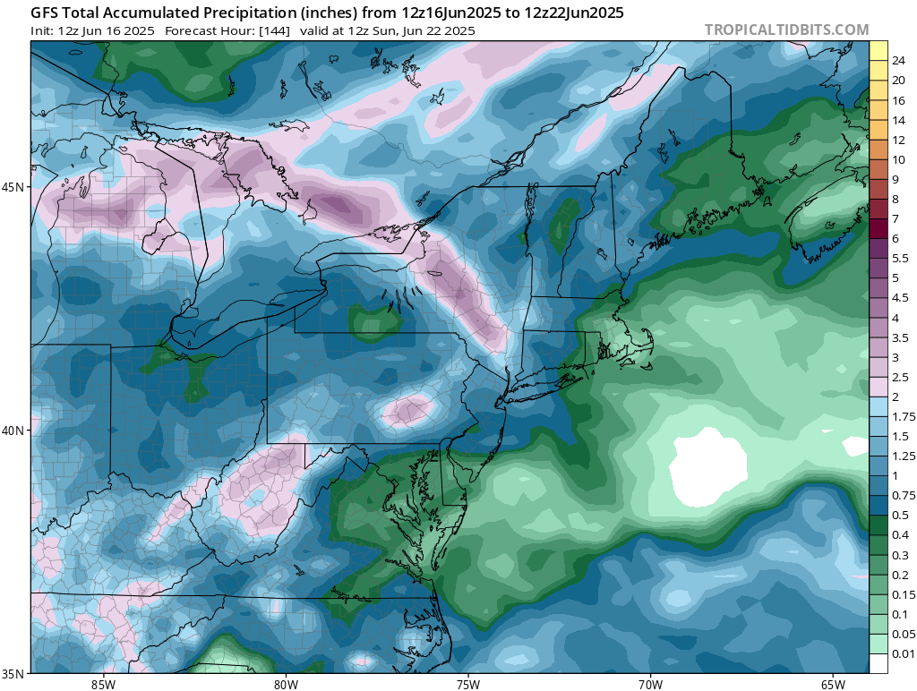
Those in the northern Appalachians will see above average rainfall this week, with multiple rounds of rain coming through from cold fronts. The rest of the northeast will see most of their rain in the early-to-mid week, with the weekend staying beautifully clear, and hot! Precipitation will be near or slightly below average.
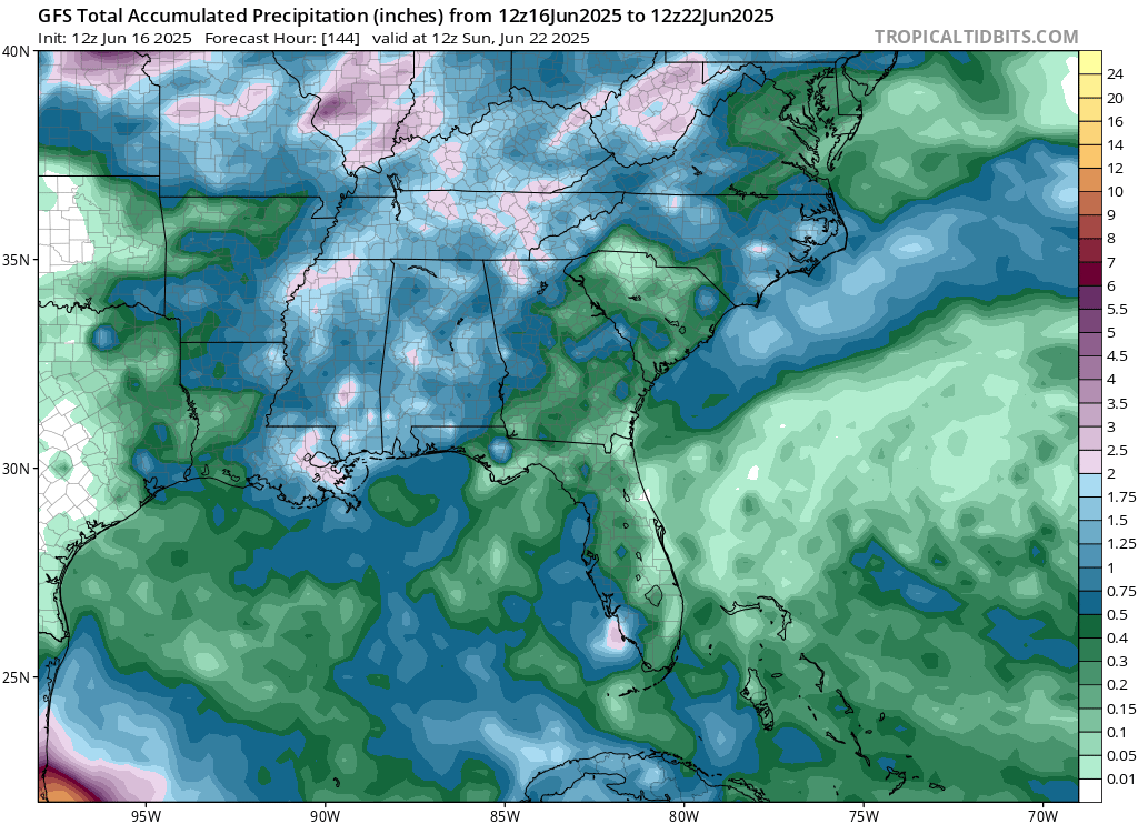
The southeast will also see most of its rain today through Friday. The weekend is looking much more clear!
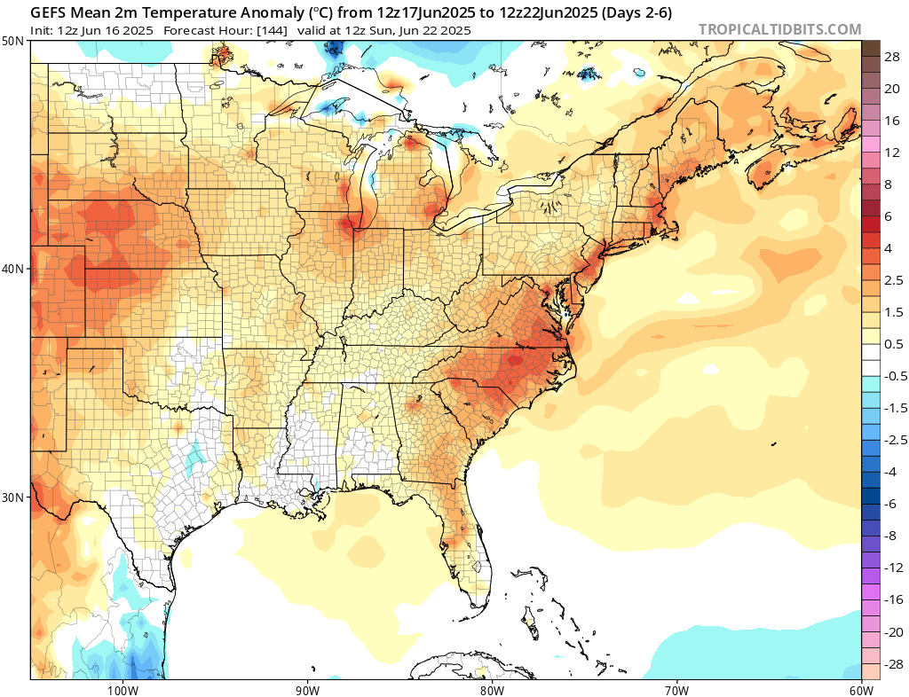
This week will be warmer than average for the majority of the east. Large-scale high pressure starts to form late-week, which brings up the temperatures and brings down the precipitation chances.
[wpcode id=”41149″]
Travel Outlook
If you’re traveling late today (Tuesday), watch for severe storms along I-70, I-135, and US-83 in central Kansas and southern Nebraska, including areas near Wichita, Garden City, and Colby. I-25 near Denver, I-80 through southern Wyoming and Nebraska, and I-35 in Kansas are also in the Slight Risk zone. Plan extra time and check the radar before heading out tonight.
For Wednesday night, the threat shifts east. Roads at risk include I-44 through Oklahoma and Missouri, I-70 from Kansas City to Indianapolis, I-55 through Illinois, and I-65 from Louisville to Chicago. It might be best to delay evening travel if possible and monitor radar for developing storms.
[wpcode id=”41149″]
Extended Outlook
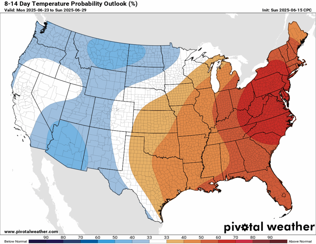

Looking ahead at the next 8-14 days, the Climate Prediction Center (CPC) is giving a high probability (60 percent) that temperatures in the east, especially the mid-Atlantic and northeast will be above average – thanks to the ridging and high pressure that stays in place until the end of June. The west, however, will be slightly cooler than average and have less precipitation. A relief from the heat in the southwest is well needed, but so is rainfall. The deserts are in a severe drought at the moment, and they will take any rainfall they can get. Good news, southeast Arizona and southern New Mexico could see above average rainfall in the next 8-14 days, which could help alleviate the drought a little bit.
[wpcode id=”41149″]
Thanks for tuning in to this National Forecast! Tune in to our local, tropical, and regional forecasts to stay updated on the latest!


