As the shortwave that brought us rain moves out, warm air will be advected behind it, and the high pressure to our south will rotate up humid Gulf air. Areas in the Mississippi River Delta and along the coast will be the most humid.
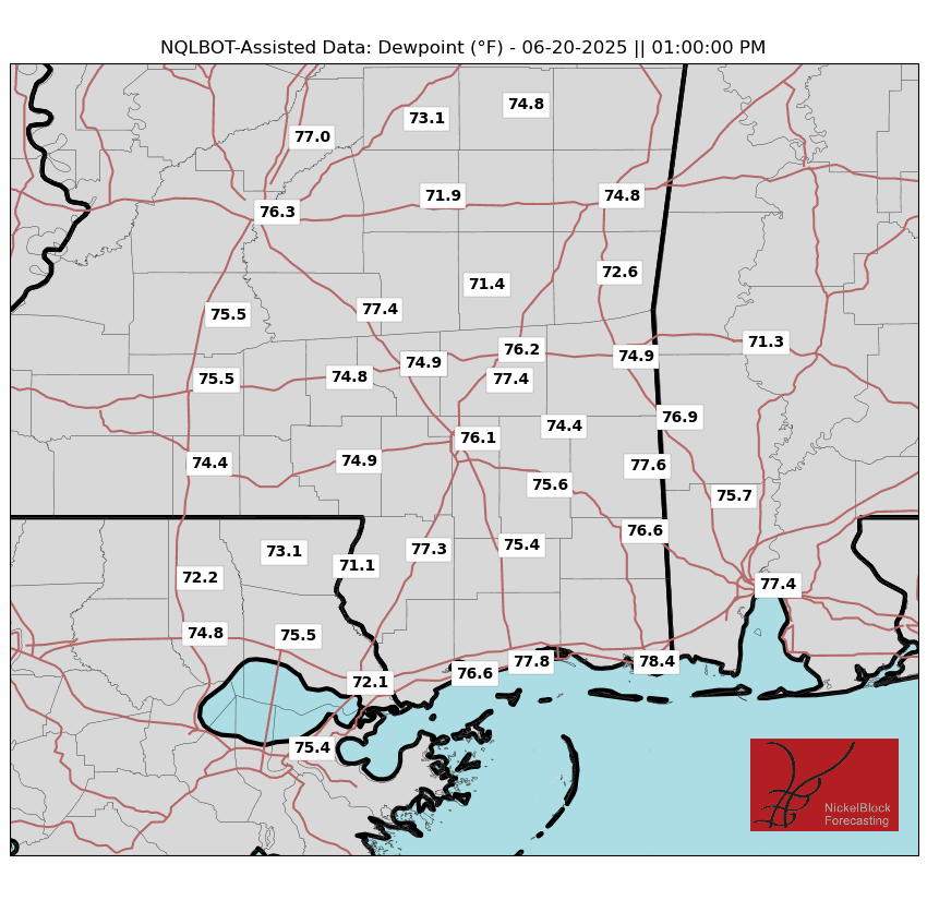
High temperatures will be seasonably average, but the dew points will make the apparent temperatures be over 105 degrees is certain areas. Since the high pressure is relatively far and weak, there won’t be many relieving breezes to speak of.
With dew points that high, convection is always possible. But after Thursday’s system moved through, it is expected a more stable setup will be in place Friday. The two good short-range models, the HRRR and NAM3km, are both not showing much precipitation, just an isolated thunderstorm or two in the late afternoon and early evening. I’d put the rain chances between 25% and 30% today.
This weekend, the dew points will decrease as the high pressure over the Gulf departs and there is no southerly flow. Besides that tidbit, expect similar conditions Saturday and Sunday, with average temperatures and below average rainfall chances.
DRYER AND HOTTER NEXT WEEK
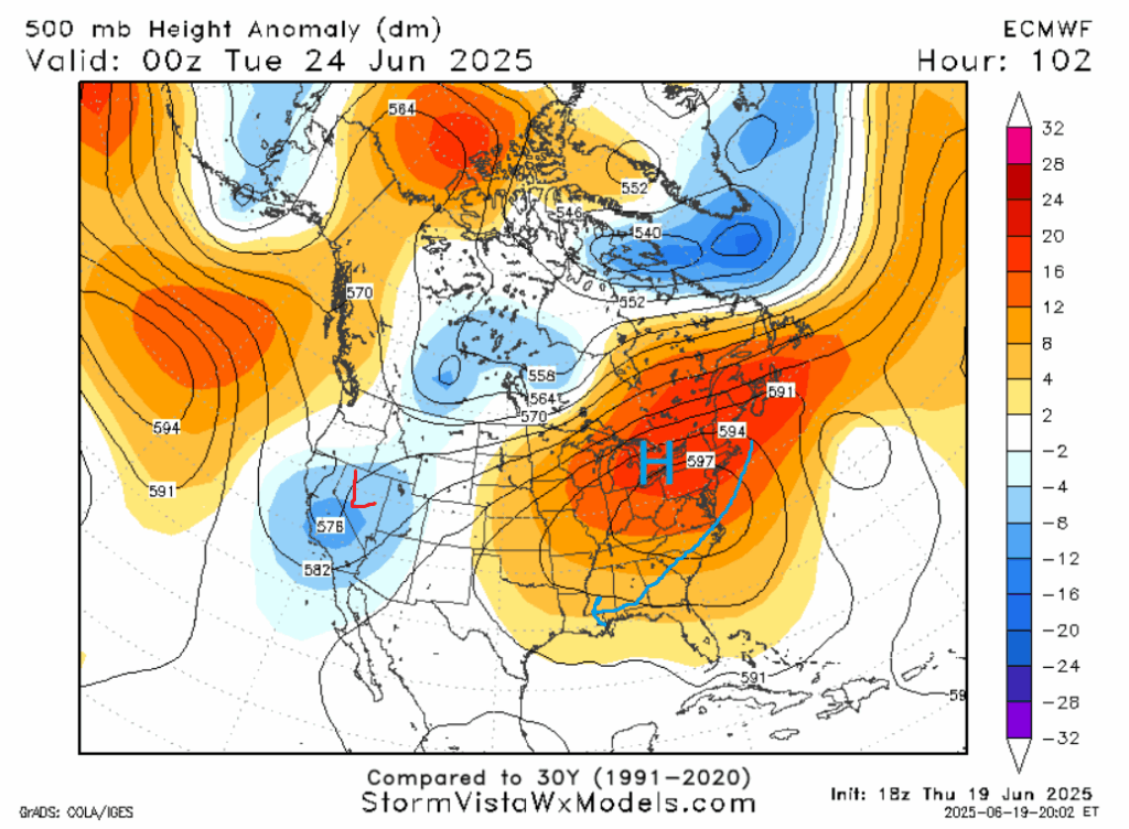
As the ridge to our north departs, the story of the meteorological world next week will be the dominant ridge in the eastern United States. Record high temperatures are expected in the Northeast as a “heat dome” settles in. From where I type in New York, it is expected that heat indexes will exceed 105, which is almost unheard of in June. Our forecast area is on the outer periphery of the ridge, so the temperature relative to average won’t be too much higher. But of course, the average temperature in Mississippi is greater than in New York, so it evens out and similar conditions are expected in those two regions.
Temperatures will flirt with 95 degrees, a threshold for which heat sickness becomes more common, basically every day next week. This ridge will also cut down our rain chances. Typically the model blend used by the National Weather Service overdoes precipitation chance in the 4-8 day time frame. But even that only shows a maximum precipitation chance of about 40% in the next 8 days. In the afternoon, if you have to be outside, please drink plenty of water, spend time in shade, and wear loose clothing. The best chance for rain will be Tuesday to Wednesday, when models show an increase in atmospheric lift.
LONG RANGE
Not this weekend but next, the ridge will begin to abate, allowing temperatures that aren’t quite as warm, as well as some relieving afternoon showers and thunderstorms, to return to the area.
A LOOK AT THE TROPICS
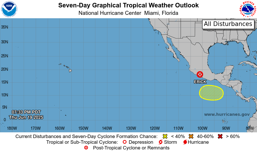
Hurricane Erick just recently made landfall in the Mexican state of Oaxaca as a Category 3 hurricane, the first ever hurricane of that intensity to hit Mexico in June. Wind damage, flooding, and storm surge all impacted communities there as well as in the neighboring state of Guerrero. Heavy rain associated with the storm’s moisture will drop lots of rain in northeastern Mexico.
There is a slight chance of tropical development in the yellow highlighted area to the south. Thankfully, it is an unlikely scenario that is impacts Mexico directly. Although, if a storm does form, its outer bands could dump some rain on the areas that were just impacted by Erick.
At this point, it seems unlikely anything will form in the Atlantic Basin in the short term. This is due to ocean water being too warm, the interference of Saharan dust, and a disadvantageous positioning of the Bermuda high.
DAY-BY-DAY FORECAST
Friday: Highs in the low 90s. Humid. Partly cloudy. Chance of rain 30%.
Friday Night: Lows in the low 70s. Mostly clear.
Saturday: Highs in the low 90s. Partly cloudy. Chance of rain 30%. Lows in the low 70s.
Sunday: Highs in the low 90s. Mostly cloudy. Chance of rain 40%. Lows in the low 70s.
Monday: Highs in the mid 90s. Partly cloudy. Chance of rain 30%. Lows in the low 70s.
Tuesday: Highs in the mid 90s. Mostly cloudy. Chance of rain 50%. Lows in the mid 70s.
Wednesday: Highs in the mid 90s. Mostly cloudy. Chance of rain 50%. Lows in the mid 70s.
Thursday: Highs in the mid 90s. Mostly cloudy. Chance of rain 40%. Lows in the mid 70s.
Friday: Highs in the mid 90s. Partly cloudy. Chance of rain 30%. Lows in the low 70s.
Saturday: Highs in the low 90s. Mostly cloudy. Chance of rain 50%. Lows in the low 70s.
Sunday: Highs in the low 90s. Mostly cloudy. Chance of rain 50%. Lows in the low 70s.
[wpcode id=”41149″]


