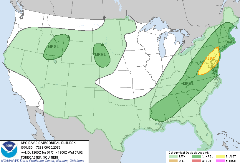
A cold front that will turn into a stationary front will park itself to our north tomorrow. This will provide a lifting mechanism that could initiate storms. There is a marginal risk of severe thunderstorms. Diurnal heating will cause temperatures to rise into the low 90s, and the dew points will rise into the mid 70s as moist air advects from the Gulf, further destabilizing the atmosphere. With minimal wind shear and convective inhibition, damaging winds are the main threat. CAPE (or atmospheric instability in layman’s terms) will be potentially above 2500 J/kg, with some cases above 3000 J/kg. Storms will likely move through in the afternoon. Areas that are affected by the most intense thunderstorms could see around an inch of rain.
REST OF THIS WEEK
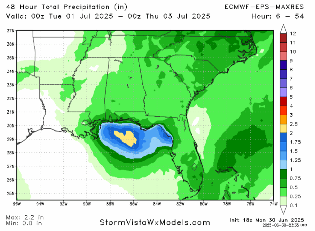
The cold front will move through the area on Wednesday, bringing with it another chance for showers and thunderstorms, although likely below severe limits. Localized rainfall amounts of 1 inch or higher are possible.
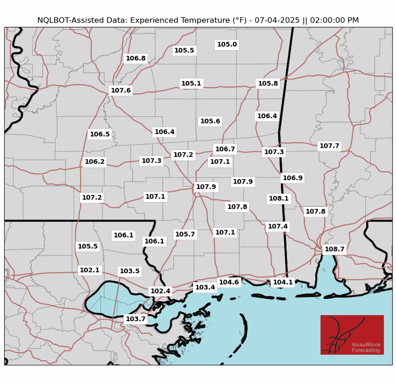
Behind this cold front will be us a nice window of dry air with no precipitation expected. Despite the fact that the front moving through will decrease temperatures, the lack of cloud cover will allow the sun to warm us back up to normal levels. The 4th of July holiday will be hot and sunny.
The weekend looks to be pretty calm. Expect temperatures in the mid 90s, with light winds and a chance of an afternoon thunderstorm. Saturday will be the day with the lower chance of rain as the drying effect of the cold front will still be present somewhat. Saturday will also probably be the hotter day, so take it easy. Heat advisories may be issued by the National Weather Service.
LONG RANGE
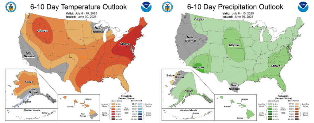
Next week, we are expecting warmer and wetter than average conditions as a southerly flow pattern asserts itself. Expect high temperatures in the mid 90s, except on days with an early afternoon thunderstorm that would cool the environment down. Monday and Tuesday seem to be the days where a storm is the most likely.
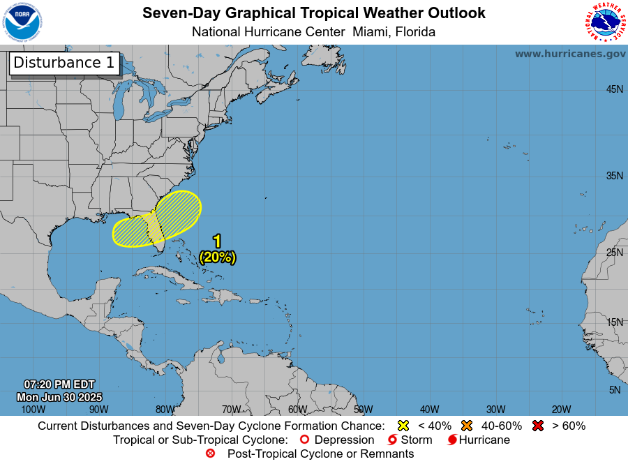
A LOOK TO THE TROPICS
The tropics are starting to get more active. Tropical Storm Flossie is currently moving parallel with the Pacific coast of Mexico, close enough to drop heavy rainfall and potentially cause tropical storm force winds along that coast. The storm might impact Baja California, but will most likely curve out to sea.
There is also an area of concern in the Gulf of Mexico, where there’s a chance a tropical storm could form and impact central Florida around the 4th of July holiday. It could also wait to form a day or two afterward, where it would spawn to the east of Florida, then move safely out into the Atlantic. It wouldn’t have enough time to get too powerful, or, in all likelihood, even reach hurricane status.
DAY-TO-DAY REGIONAL FORECAST
Today: Highs in the low 90s. Muggy. Thunderstorms with gusty winds possible, especially in early afternoon. Chance of rain 80%.
Tonight: Lows in the mid 70s. Mostly clear.
Wednesday: Highs in the low 90s. Muggy. Thunderstorms in the late afternoon to early evening. Chance of rain 60%. Lows in the low 70s.
Thursday: Highs in the low 90s. Partly cloudy. Lows in the low 70s.
Friday (4th of July): Highs in the mid 90s. Mostly sunny. Lows in the low 70s.
Saturday: Highs in the upper 90s. Partly cloudy. Lows in the mid 70s.
Sunday: Highs in the mid 90s. Partly cloudy, chance of an afternoon shower. Chance of rain 30%. Lows in the low 70s.
Monday: Highs in the mid 90s. Partly cloudy, chance of an afternoon storm. Chance of rain 40%. Lows in the low 70s.
Tuesday: Highs in the mid 90s. Partly cloudy, chance of an afternoon storm. Chance of rain 40%. Lows in the low 70s.
Wednesday: Highs in the mid 90s. Partly cloudy. Lows in the low 70s.
Thursday: Highs in the mid 90s. Partly cloudy. Chance of rain 30%. Lows in the low 70s.
[wpcode id=”41149″]


