Hi everyone! Thank you for reading my first case study review about a weather event that you all likely know very well. On the night of March 24, 2023, a violent tornado tore through Rolling Fork and Silver City, Mississippi, killing 17 people and injuring over 160. Rated EF4 with peak winds estimated at 195 mph, this tornado became one of the deadliest and most destructive in recent Mississippi history. It carved a path nearly 60 miles long, was on the ground for over an hour, and caused catastrophic damage, despite being exceptionally well forecasted. This tornado was part of a larger outbreak that stretched from Texas to Tennessee, but Rolling Fork took the brunt of the worst damage.
In this review, I’ll walk through the meteorological setup, the storm’s evolution, and the descruction it left along it’s path.
Atmospheric Setup
Water vapor imagery that morning showed a potent mid-level trough ejecting eastward, with a rapidly deepening surface low across Arkansas. The warm sector became increasingly unstable through the day, and by early evening, supercells were beginning to develop near the Louisiana–Mississippi border.
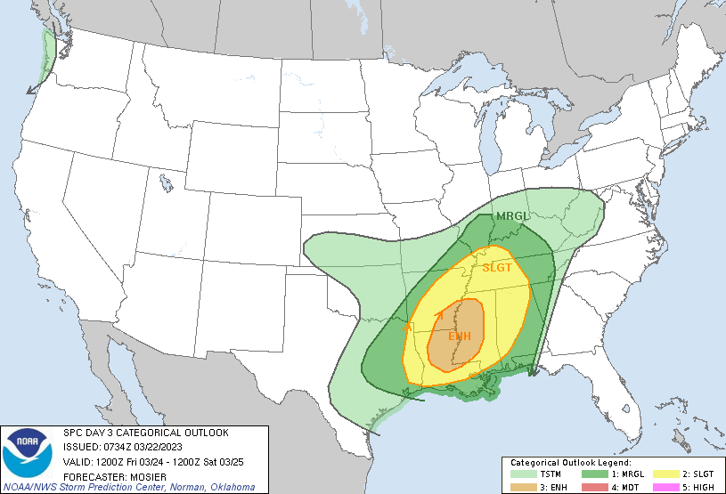
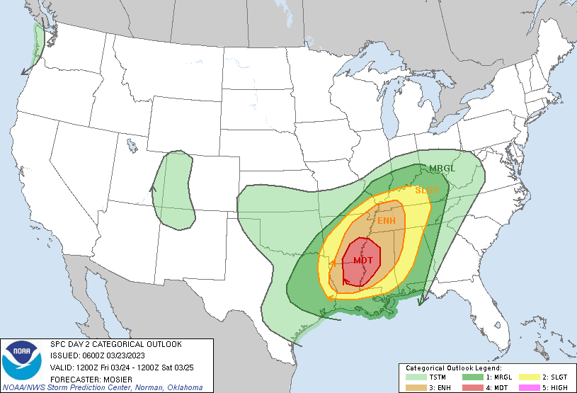
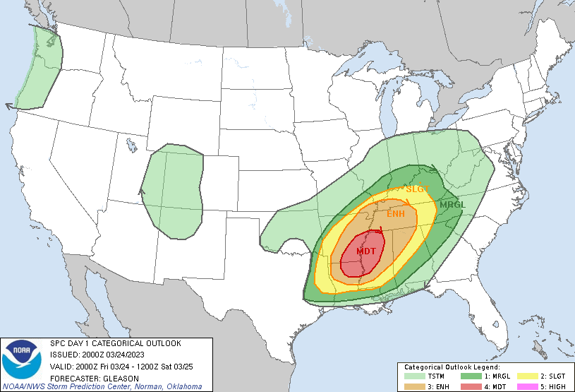
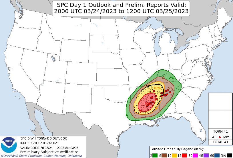
The Storm Prediction Center (SPC) began highlighting the Lower Mississippi Valley as early as Wednesday 3/22 on the Day 3 outlook, noting the potential for “supercell thunderstorms capable of all severe hazards, including strong tornadoes”. A Marginal (3/5) risk was highlighted over the region, and over Rolling Fork, which is quite telling that the SPC was confident that the setup was concerning for severe weather that day. By Thursday 3/23, on the Day 2 outlook, a Moderate (4/5) Risk was issued, along with a hatched 15 percent tornado risk. The hatched tornado risk means that there is a 10 percent or greater probability of EF2 – EF5 tornadoes within 25 miles of a point. The Moderate (4/5) risk and the hatched tornado risk stayed for the day of the tornado, Day 1. You may be thinking, why wasn’t a High (5/5) risk issued? It was mostly due to a pocket of dry air just above 850 mb that the SPC said limited buoyancy. CAPE values were supportive of severe thunderstorms and tornadoes, but not on the very high side. The tornado reports closely matched the SPC’s forecasted risk zones, as shown in the figure above, indicating a highly accurate prediction.
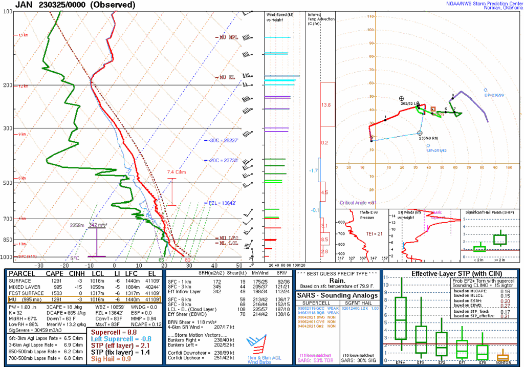
The 00Z Jackson, MS sounding on March 24 showed a favorable environment for tornadic supercells. While instability wasn’t extreme (with CAPE values around 1,300–1,500 J/kg), it was more than sufficient given the strong wind shear in place. Winds turned sharply with height, shown by the large curved hodograph, which supports rotating storms. Storm-relative helicity (SRH) values exceeded 300 m²/s², signaling strong low-level spin. The cloud base (LCL) was low enough to support tornado formation, and the effective-layer significant tornado parameter (STP) was elevated, pointing to a favorable environment for a strong tornado if a storm could mature – which one did, just an hour later.
The Tornado Develops
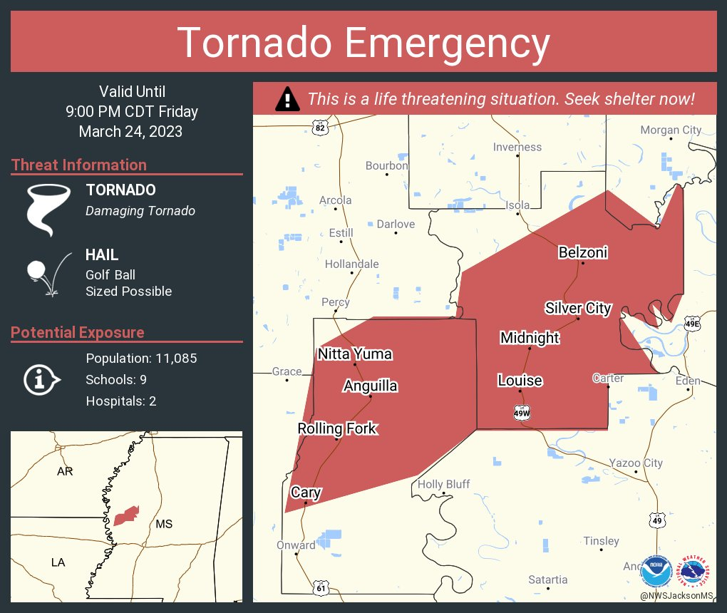
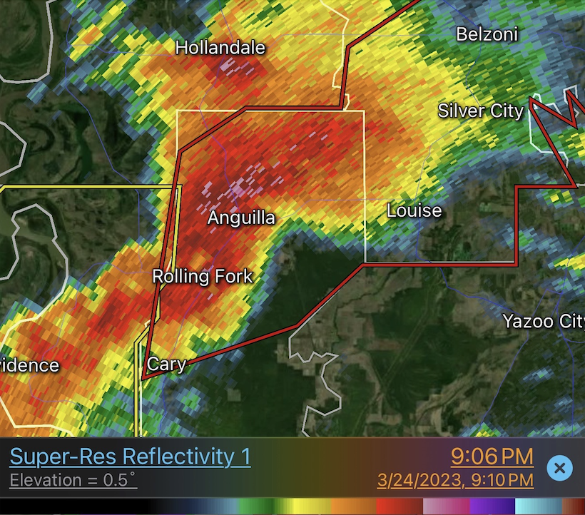
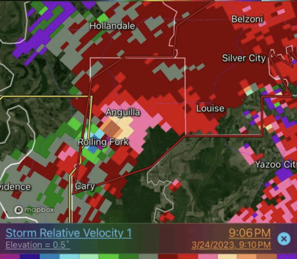
A supercell near the Louisiana–Mississippi border quickly developed as it tracked northeast, and by 7:57 PM CDT, radar showed a strong velocity couplet near Eagle Bend, Mississippi. A tornado formed shortly after and rapidly intensified. By 8:04 PM, a Tornado Emergency was issued as it approached Rolling Fork. As the storm moved through town, radar confirmed debris being lofted over 13,000 feet and gate-to-gate rotation of about 70 knots. The SPC issued a rare meso-gamma scale mesoscale discussion while the tornado was still ongoing, calling attention to the violent nature of the storm based entirely on real-time Doppler radar.
After moving through Rolling Fork, the tornado kept tracking northeast at around 50 mph, staying strong as it crossed open fields and headed toward Anguilla. Radar still showed a solid debris signature and strong rotation, so there was no sign of it letting up yet. It entered Humphreys County next, clipping areas near Midnight before reaching Silver City. By that point, it had started to weaken a bit, but was still clearly producing debris and holding onto some strong low-level rotation. The tornado finally lifted at 9:08 PM CDT in Holmes County, just northeast of the Morgan Brake National Wildlife Refuge, wrapping up a 59-mile track that lasted over an hour.
Catastrophic Damage

The tornado caused widespread destruction through the heart of Rolling Fork, with damage consistent with high-end EF4 intensity. Dozens of homes were completely leveled, and several well-built structures were reduced to bare foundations. One of the most notable examples was the Green Apple Florist, which was swept clean off its slab – a damage indicator that came close to qualifying for EF5. While the tornado briefly weakened as it moved through town, it quickly regained strength near MS 14, where more buildings were flattened, vehicles were tossed, and radar continued showing strong debris lofting. The storm remained powerful as it exited Rolling Fork and continued northeast.
In total, over 300 homes were damaged in Rolling Fork, and roughly 78 percent of the town sustained some level of destruction. Silver City saw similar devastation, with 96 percent of the town affected. Critical infrastructure, including the hospital, schools, city hall, and a major water tower, was either damaged or destroyed. Insured losses were estimated near $100 million, though actual total losses were likely much higher. At one point, nearly 500 residents were displaced, and months later, many had still not returned home.
Final Thoughts
The Rolling Fork tornado was one of the most intense tornadoes Mississippi has seen in a long time, and it happened in a setup that was well-forecasted days in advance. The SPC highlighted this region from Day 3 through Day 1, and while a High Risk wasn’t issued, the Moderate Risk with a hatched 15 percent tornado area was more than justified. The environment wasn’t over-the-top unstable, but there was enough CAPE and plenty of shear for a strong tornado to form, and that’s exactly what happened. What stood out to me was how fast the storm ramped up, how clear the radar signatures were, and how long the tornado stayed on the ground. It’s a reminder that you don’t need extreme numbers to get a high-end event. One supercell in the right spot at the right time can do a lot of damage. This is the kind of case that I would assume really sticks with you, especially being so close to home.
Check out https://storymaps.arcgis.com/stories/498732c9fda04e6c85118c8e96e47de7 for a complete timeline of this deadly tornado.
Sources
American Meteorological Society. (2024, January). 3.5 Challenges and best practices for assessing catastrophic tornado damage across a vulnerable community: Rolling Fork, Mississippi. 104th AMS Annual Meeting. https://ams.confex.com/ams/104ANNUAL/webprogram/Paper433866.html
ArcGIS StoryMaps. (2023). Rolling Fork Tornado Damage Assessment StoryMap. https://storymaps.arcgis.com/stories/498732c9fda04e6c85118c8e96e47de7
Storm Prediction Center. (2023). SPC Convective Outlook Archives: March 22–24, 2023. NOAA/NWS. https://www.spc.noaa.gov/cgi-bin-spc/getacrange-aws.pl?date0=20230322&date1=20230324
Wikipedia contributors. (2023, July 13). 2023 Rolling Fork–Silver City tornado. Wikipedia. https://en.wikipedia.org/wiki/2023_Rolling_Fork%E2%80%93Silver_City_tornado


