You may have heard in the past couple days that there is some potential tropical development on the Gulf Coast. Regardless of how much this storm develops or whether it develops at all, heavy rain and flash flooding will definitely be a concern to be prepared for starting today and through the weekend.
Current situation in the Atlantic
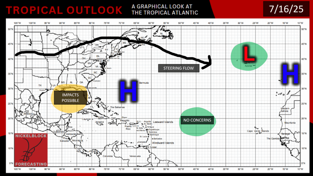
We currently have high pressure spanning the Atlantic Ocean, and a closed low pressure over the Azores, which will have no impact to us. Most importantly is the area of potential development in the Gulf, so let’s take a closer look at what’s going on:
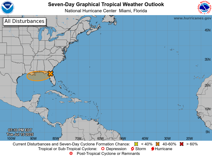
As of Tuesday evening, the area of development has a 40% chance of development in the next 48 hours, and also in the next 7 days. An area of low pressure has developed and is now moving over Florida and then along the Gulf Coast. This low pressure area contains bands of disorganized showers and thunderstorms. Environmental conditions look favorable for this area to keep developing as long as it stays offshore, as landfall will help to weaken this system. This area will most likely continue to develop for a bit, and we may even see it develop into a tropical depression in the next couple of days if it stays over the Gulf.
Possible impacts
The main concern from this development is heavy rainfall beginning today and persisting until Sunday. Heavy rainfall in some areas can cause flash flooding, especially in urban areas or areas in steeper terrain, so definitely be prepared and have a plan for possible flash flooding through Sunday. Currently, there is a flood watch for much of Southeast Louisiana from the NWS New Orleans office, so keep an eye on the forecast and watch for any flash flood warnings.
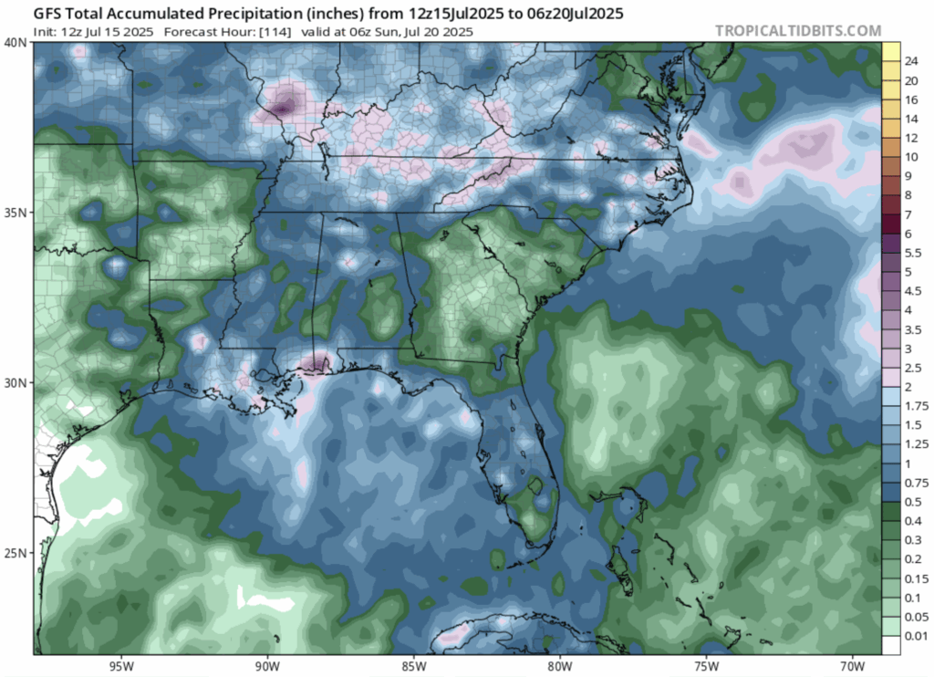
Here’s what the radar is looking like for now through this Sunday:
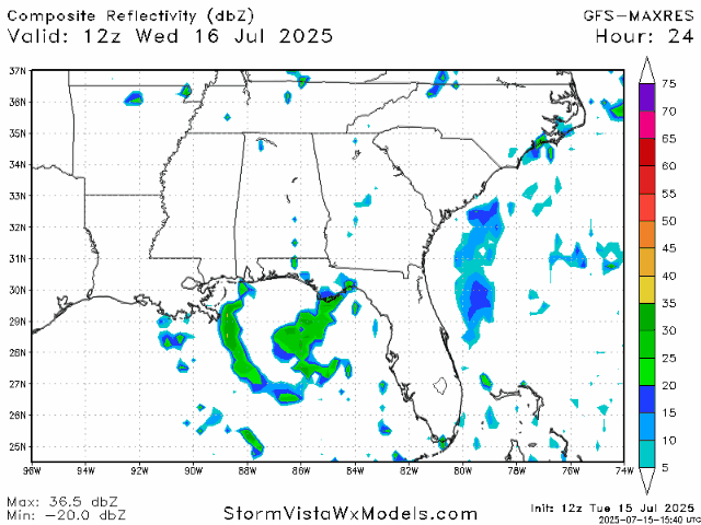
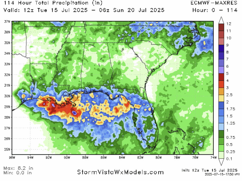
It’s looking like the worst of the rain will be from tonight through early tomorrow morning. As for how much rain we are going to get – it’s not completely clear yet. The National Hurricane Center and local NWS offices are still unsure of exactly how much rain we can expect in what exact places. Looking at the models, each one has differing results from this system. From the GFS (US-based model) we can expect rainfall totals from this tropical system to range from less than an inch in certain areas of Central Mississippi and Alabama to up to 4 inches on the coast of the Mississippi/Alabama border. The ECMWF (European-based model) shows a larger impact on Southeast Louisiana, expecting up to 3 inches of rain in that area, up to 2 inches for the rest of the Gulf Coast, and less than an inch for the rest of MS and AL. Note that although the maximum total precipitation in the Euro model says 8.2 inches, but that area is well offshore, so I’ve only noted the maximum rainfall on land.
Regardless of your exact location, it is extremely important to be prepared for heavy rainfall and flooding as we get closer to the time that flood warnings would be issued. I would expect actual warnings (not watches) from local authorities to begin probably by this evening. If you are driving and come across a flooded roadway, don’t go through it, turn around and find another route. Be especially careful with driving at night, as that is the expected start time of the heavy rain, plus it will be extremely harder to see flooded areas in the dark. If you can avoid driving or being outside tonight and early tomorrow morning, I would advise that.
A Quick Look at the Pacific – Nothing for Now
As for the Pacific, there are no active disturbances currently, and none expected in the next week. Sea surface temperatures are starting to warm up slightly after being cooled by previous systems churning up some colder water. Looking at relative humidity in the mid-levels of the atmosphere, the area will generally stay pretty dry in the next few days, especially in the specific areas that most of the tropical disturbances have formed this hurricane season. Wind shear is looking patchy, some areas have none, some a lot. For something to form, some showers and thunderstorms would have to find one of these pockets of low wind shear to organize themselves in, with sufficient humidity involved as well. I don’t see this happening in the next few days, but possibly something could pop up later next week.
Please stay tuned for more NickelBlock tropical updates, and stay safe this week!


