Over the next seven days, the Gulf States will experience a dynamic weather pattern shaped by tropical moisture and shifting atmospheric conditions. Thursday begins under a weakening ridge, allowing Invest 93L to bring humidity and scattered coastal storms. Friday turns wetter as the tropical system drifts inland, fueling widespread, slow-moving thunderstorms and flash flooding across Louisiana and Mississippi. Saturday continues with lingering rainfall and saturated grounds, keeping flooding concerns alive. By Sunday and Monday, drier mid-level air and rebuilt high pressure suppress storm activity, bringing back sunshine and heat. Tuesday and Wednesday mark a return to typical summer conditions, hot, humid, and mostly sunny, with isolated afternoon storms possible inland as Gulf moisture creeps back in.
Heat, Humidity & Tropical Influence — Thursday to Saturday
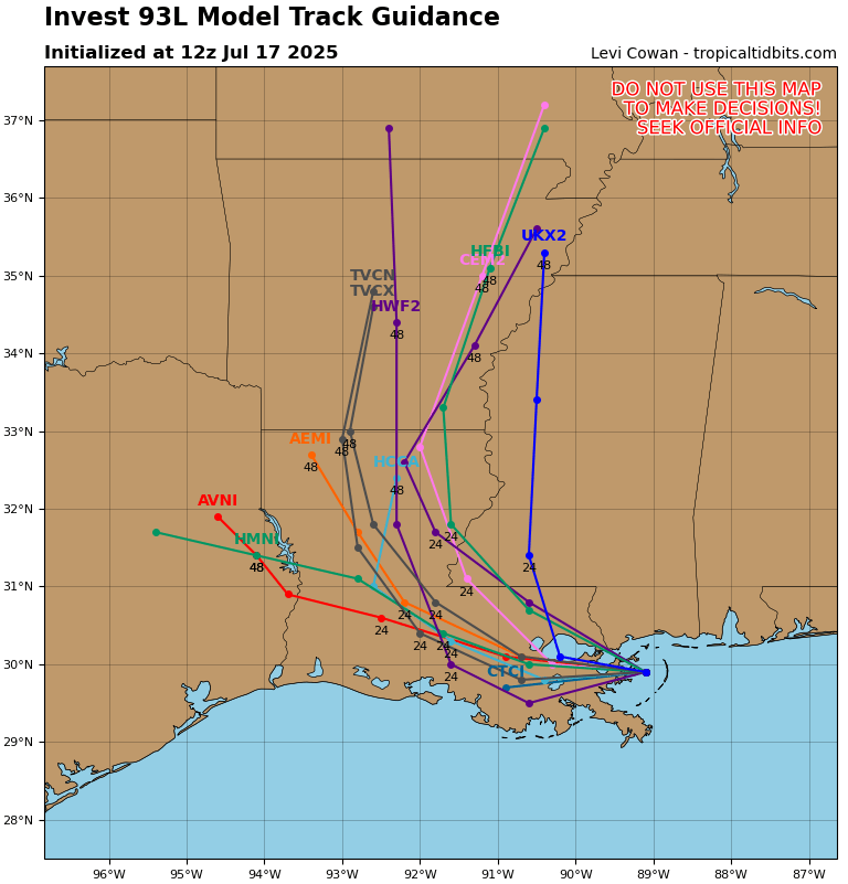
Invest 93L Model Track Guidance // Courtesy: Tropical Tidbits
From Thursday through Saturday, the Gulf States lie under the influence of a weakening high-pressure ridge and a persistent influx of tropical moisture from Invest 93L. On Thursday, surface dew points climb into the mid to upper 70s as moisture gradually pushes northward from the Gulf, triggering scattered thunderstorms along the Louisiana and Mississippi coasts. By Friday, Invest 93L brings a pronounced surge of tropical humidity, with precipitable water values exceeding 2.0 inches and weak steering flow allowing slow-moving, training thunderstorms. These storms lead to widespread flash flooding, especially south of I-10 in Louisiana and central Mississippi, as urban and low-lying areas become overwhelmed by rainfall rates exceeding 2–3 inches per hour. Saturday continues with scattered convection driven by lingering moisture, afternoon heating, and remnant outflow boundaries. Though storm coverage begins to decline, saturated soils and overburdened drainage systems maintain flood concerns through the evening hours.
Drying and Stabilization — Sunday & Monday
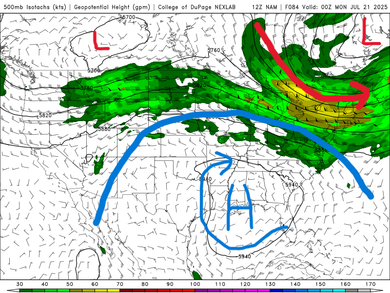
500 mb map for Sunday from the NAM model. //Courtesy: College of DuPage
A shift in the mid-level pattern begins on Sunday, as drier air filters in from the Southern Plains, weakening deep moisture profiles across Louisiana, Mississippi, and Alabama. The presence of residual surface humidity allows for isolated coastal and inland storms, but the lack of dynamic support aloft limits vertical development, leading to shorter-lived afternoon showers. Temperatures recover into the low 90s under partly sunny skies. By Monday, high-pressure ridging reestablishes itself in the mid and upper levels, increasing convective inhibition (CIN) and reducing cloud cover. The air mass becomes more stable, leading to widespread subsidence and minimal storm potential. As a result, the region experiences a return to classic summer conditions with mostly sunny skies, slightly lower humidity, and heat indices hovering near 100°F. A heat dome due to the strengthening ridge will develop and remain through the week.
Summer Heat with Storm Chances — Tuesday & Wednesday
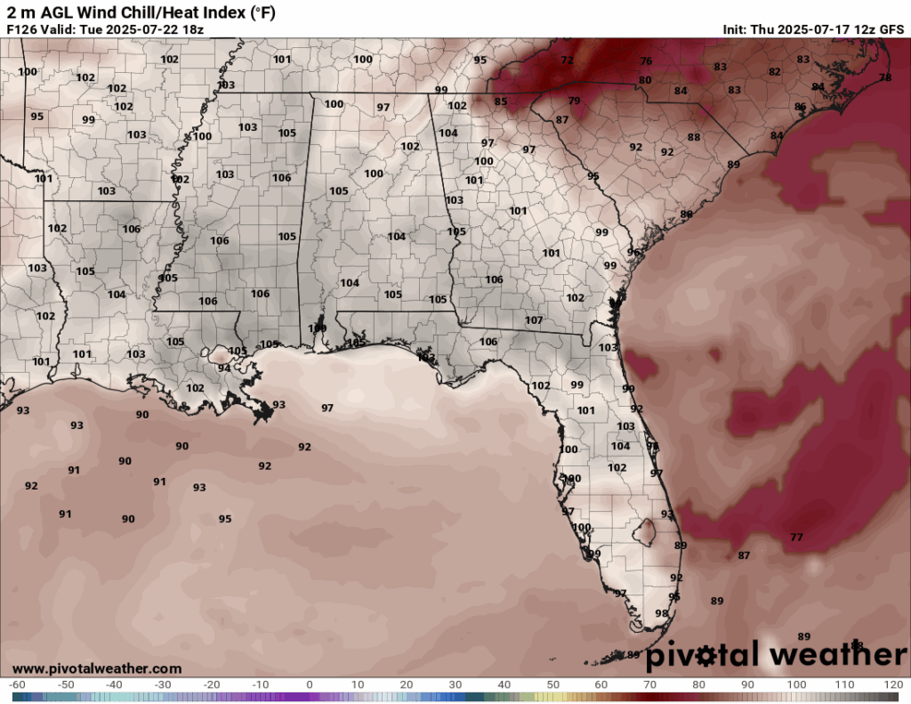
Heat index for Tuesday of next week from the GFS model. //Courtesy: Pivotal Weather
Tuesday and Wednesday mark a return to seasonal Gulf Coast weather, with hot, humid conditions and the daily chance of isolated to scattered thunderstorms. On Tuesday, subsidence from lingering ridge influence maintains mostly dry conditions through midday, but intense surface heating may spark a few pop-up showers inland during the late afternoon. Highs climb into the mid-90s, and heat indices reach up to 105°F due to persistent Gulf humidity. By Wednesday, a subtle shift in wind direction to a more southerly flow enhances low-level moisture, increasing the likelihood of late-day storms, especially in central Mississippi and inland Alabama. While not as widespread or intense as Friday’s events, Wednesday’s convection could produce gusty winds, brief downpours, and frequent lightning under a slightly more unstable profile.
Regional Day-to-Day Forecast
Thursday – A 50% chance of showers and thunderstorms, mainly in the afternoon. Partly sunny, with a high near 91°F. Southeast wind 5 to 10 mph.
Thursday Night – A 60% chance of showers and thunderstorms. Mostly cloudy, with a low around 76°F. Southeast wind around 5 mph.
Friday – Showers and thunderstorms likely. Mostly cloudy, with a high near 88°F. South wind 5 to 10 mph. Chance of precipitation is 80%.
Friday Night – A 50% chance of showers and thunderstorms. Mostly cloudy, with a low around 75°F. South wind around 5 mph.
Saturday – Showers and thunderstorms likely. Partly sunny, with a high near 89°F. South wind 5 to 10 mph. Chance of precipitation is 70%.
Saturday Night – A 40% chance of showers and thunderstorms. Partly cloudy, with a low around 76°F. South wind around 5 mph.
Sunday – A 60% chance of showers and thunderstorms. Mostly sunny, with a high near 91°F. West wind 5 to 10 mph becoming south in the afternoon.
Sunday Night – A 30% chance of showers and thunderstorms. Partly cloudy, with a low around 77°F. Southwest wind around 5 mph.
Monday – A 50% chance of showers and thunderstorms. Mostly sunny, with a high near 92°F. Southwest wind 5 to 10 mph.
Monday Night – A 40% chance of showers and thunderstorms. Partly cloudy, with a low around 77°F.
Tuesday – A 40% chance of showers and thunderstorms. Mostly sunny, with a high near 93°F. Heat index values may reach 106°F. Northwest wind around 5 mph becoming southwest in the afternoon.
Tuesday Night – A 20% chance of showers and thunderstorms. Partly cloudy, with a low around 77°F. Southwest wind around 5 mph becoming northwest after midnight.
Wednesday – Showers and thunderstorms likely. Partly sunny, with a high near 93°F. North wind around 5 mph becoming south in the afternoon. Chance of precipitation is 60%.
Wednesday Night – A 60% chance of showers and thunderstorms. Mostly cloudy, with a low around 75°F. North wind around 5 mph becoming east after midnight.


