A strong upper-level ridge will dominate the early portion of the week across the Gulf Coast States, fostering a period of intense heat and minimal cloud cover as subsidence suppresses convection. High temperatures will reach into the upper 90s, and high dew points will push heat indices well above 105°F, especially in urban areas affected by stagnant mixing and poor dispersion. By midweek, a weak frontal boundary slipping south introduces enhanced moisture and instability, with widespread thunderstorms likely Thursday and Friday. Atmospheric parameters suggest elevated CAPE and anomalously high PWAT values, supporting heavy rainfall and localized flooding in vulnerable zones. Heading into the weekend, upper-level flow becomes more zonal and the frontal forcing dissipates, allowing the ridge to gradually rebuild aloft. This will lead to improving conditions by Saturday through Monday, with fewer storms, mostly sunny skies, and highs in the low 90s under the influence of re-strengthening high pressure.
Scorching Start with Heat Domes (Tue–Wed)
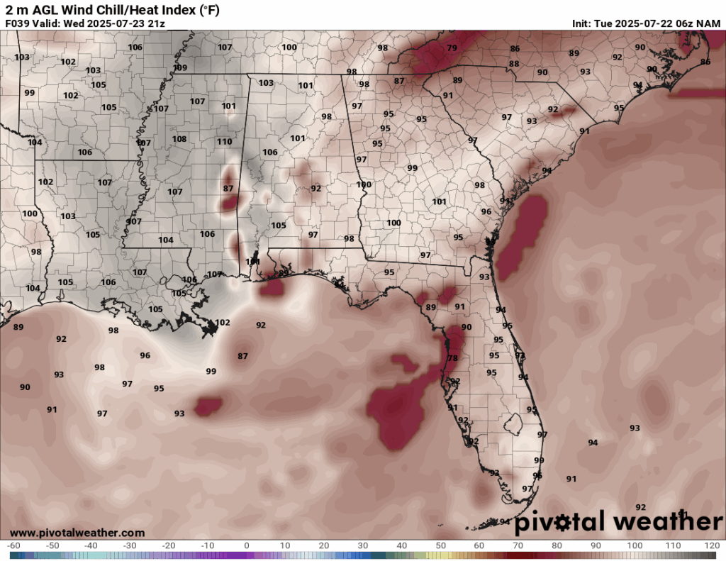
Heat index for Wednesday from the NAM model. //Courtesy: Pivotal Weather
Tuesday and Wednesday bring intense heat across all three states, dominated by a stubborn subtropical ridge. This high-pressure system acts as a cap on the atmosphere, keeping skies clear and trapping warm air. Temperatures soar into the mid to upper 90s, with heat indices breaking the 100°F mark in LA and MS. Elevated humidity adds to the discomfort, and heat advisories are in effect early in the week.
Thunderstorm Surge & Rainy Stretch (Thu–Fri)
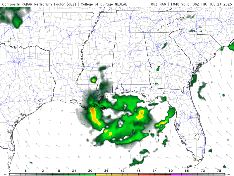
Radar Reflectivity Thursday through Friday from the NAM model. //Courtesy: Pivotal Weather
Thursday and Friday see a notable shift, as a weak frontal boundary and upper-level trough stir instability. This interacts with Gulf moisture and daytime heating, triggering scattered thunderstorms and locally heavy rainfall, especially in LA and central MS. Rainfall amounts may top a half an inch to over 1 inch in some areas, with flooding possible in poorly drained or low-lying regions. AL remains under stormy skies as well, although rainfall coverage may be slightly more scattered.
Easing Rain & Warming Trend (Sat–Mon)
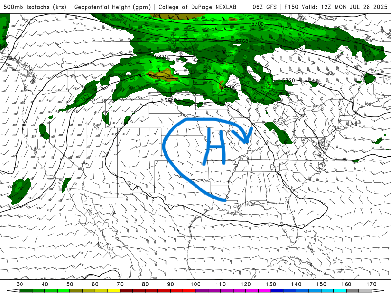
500 mb map for next Monday from the GFS model. //Courtesy: College of DuPage
By Saturday through Monday, the atmosphere starts to stabilize. Rain chances taper off across LA, MS, and AL, though isolated showers linger, especially near the Gulf Coast. Temperatures rebound into the low 90s, with mostly sunny skies returning inland. This period marks a classic Southern midsummer pattern, warm, humid, and relatively calm, with spotty convection possible but less widespread than before.
Regional Day-to-Day Forecast
Tuesday – Mostly sunny with a high near 96°F. Heat index values between 103–107°F. South wind 5 to 10 mph.
Tuesday Night – Mostly clear, with a low around 77°F. Light south wind.
Wednesday – Partly sunny, with a high near 94°F. A 30% chance of afternoon showers and thunderstorms. South-southeast wind 5 to 10 mph.
Wednesday Night – A 40% chance of showers and thunderstorms. Mostly cloudy, with a low near 76°F. South wind around 5 mph.
Thursday – A 50% chance of showers and thunderstorms, mainly in the afternoon. Partly sunny, with a high near 91°F. Southeast wind 5 to 10 mph.
Thursday Night – A 60% chance of showers and thunderstorms. Mostly cloudy, with a low around 76°F. Southeast wind around 5 mph.
Friday – A 40% chance of showers and thunderstorms. Mostly cloudy, with a high near 89°F. Winds light and variable.
Friday Night – A 30% chance of evening showers and thunderstorms. Partly cloudy, with a low around 75°F.
Saturday – Mostly sunny with a 20% chance of isolated afternoon showers. High near 91°F. East wind 5 to 10 mph.
Saturday Night – Partly cloudy, with a low around 74°F. Light winds.
Sunday – Mostly sunny with a high near 92°F. Slight chance of a thunderstorm (20%). Light southeast wind.
Sunday Night – Partly cloudy, with a low around 75°F. Calm winds.
Partly sunny with a 30% chance of afternoon showers and thunderstorms. High near 91°F. Southeast wind 5 to 10 mph.
Monday Night – A 20% chance of showers. Mostly cloudy, with a low around 76°F.


