From July 24 to 31, the Gulf Coast states experience four distinct weather patterns. Starting on Thursday and Friday, scattered showers fueled by Gulf moisture bring high humidity and heat indices. On Saturday and Sunday, sunny skies and ridging drive temps into the mid-90s°F. Monday and Tuesday mark the peak heat with highs near 100°F under dominant high pressure. By Wednesday and Thursday, moisture returns, sparking light rain in parts of MS and LA, while AL stays mostly dry. Throughout, humidity keeps conditions sweltering.
Unsettled & Humid: Friday
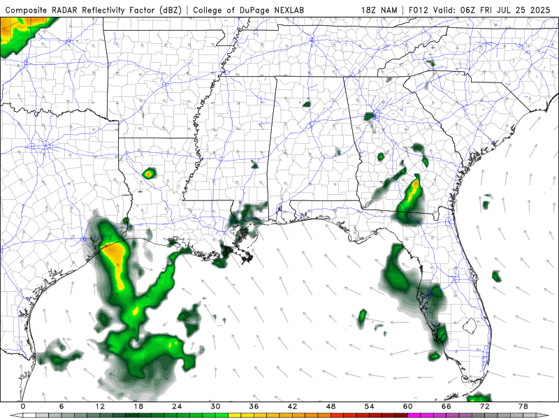
Radar Reflectivity for Friday from the NAM model. //Courtesy: Pivotal Weather
A weak, slow-moving upper-level trough over the northern Gulf Coast acts as a catalyst for scattered shower and thunderstorm development across Louisiana and Mississippi, with some spillover into Alabama. This synoptic setup allows deep-layer moisture from the Gulf to pool inland, while daytime heating boosts instability. As the trough remains quasi-stationary, vertical motion is sustained, particularly during the afternoon hours. Surface dewpoints remain in the mid-to-upper 70s°F, creating oppressive humidity and enabling convective downpours, especially over coastal LA. Patchy cloud cover keeps radiative heating somewhat in check, but heat indices still rise above 100°F in urban corridors. Atmospheric profiles indicate limited wind shear, so storms will be slow-moving and localized, elevating the risk for brief urban flooding.
Dry & Heating Up: Saturday–Sunday
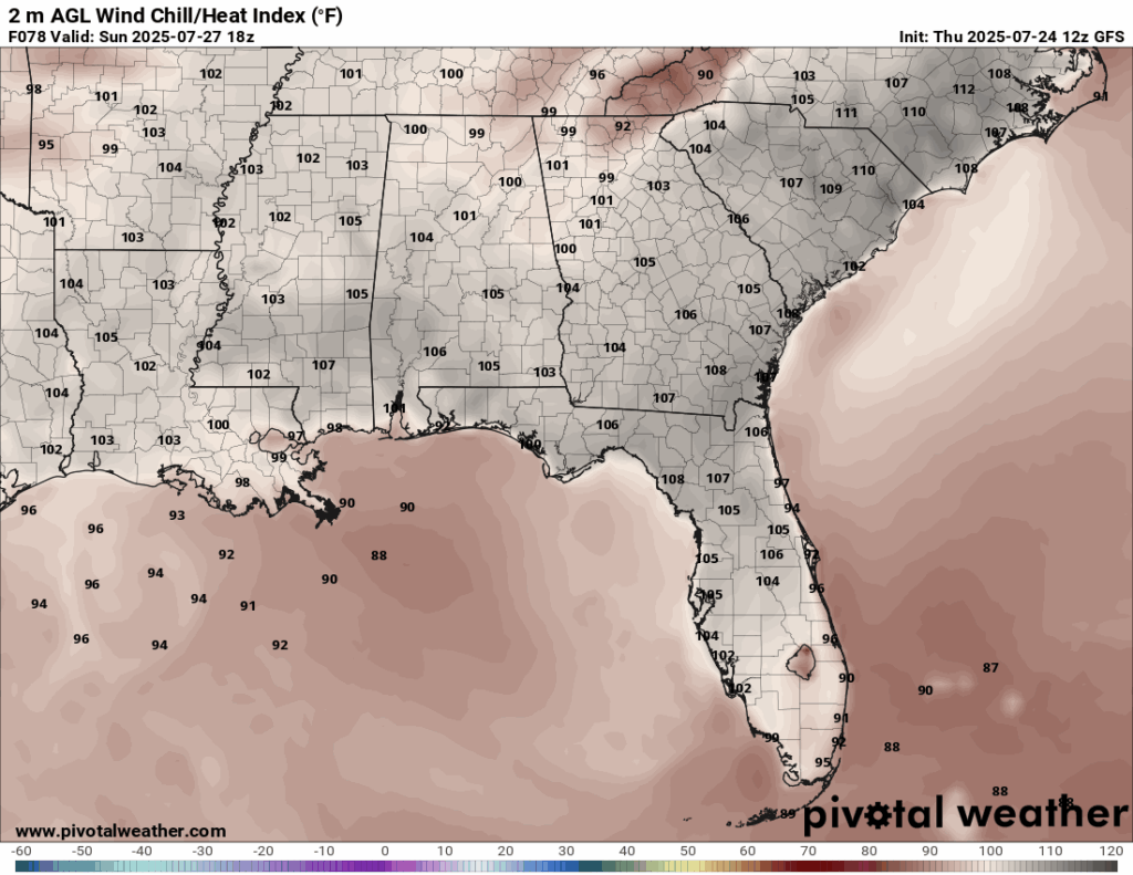
Heat index for Sunday from the GFS model. //Courtesy: Pivotal Weather
Mid-level ridging builds across the Southeast, ushering in a period of subsidence and stable conditions. This suppresses cloud formation and caps convective development, leading to mostly sunny skies across Mississippi and Alabama. Louisiana may still contend with marginal instability near the coast, but any precipitation is expected to be brief and widely scattered. The clear skies and stagnant air allow maximum solar insolation, causing temperatures to climb into the mid-90s°F across the region. Heat advisories become increasingly likely, as the absence of wind and high dewpoints produce heat indices reaching 105–107°F. The stagnant atmospheric pattern also traps pollutants near the surface, potentially degrading air quality in metropolitan areas. With little nighttime relief, elevated minimum temperatures may stress vulnerable populations and increase energy demand for cooling.
Scorching & Stable: Monday–Tuesday
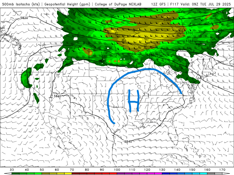
500 mb map for next Tuesday from the GFS model. //Courtesy: College of DuPage
A robust surface and mid-level high-pressure system entrenches itself over the Gulf South, promoting an extremely stable and dry air mass. This leads to widespread sunshine and near-cloudless conditions throughout Alabama, Mississippi, and much of Louisiana. Thermal profiles reveal poor vertical mixing, resulting in surface heat accumulation and sustained maximum temperatures between 97°F and 100°F, especially in inland Alabama. Despite slightly lower relative humidity values, the ambient heat remains hazardous, with apparent temperatures exceeding 110°F in localized pockets. The only exception may be southern Louisiana, where a weak easterly wave could generate isolated late-day showers near the Gulf. This setup reflects a textbook dome of high pressure, limited convection, enhanced surface heating, and reduced cooling at night, factors that amplify heat risk and reduce agricultural soil moisture levels.
Moisture Returns: Wednesday–Thursday
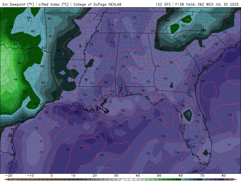
Dew Point Temperatures for Wednesday/Thursday of next week from the GFS model. //Courtesy: College of DuPage
By midweek, the high-pressure ridge retreats westward, allowing for a modest influx of Gulf moisture into the southern tier of the region. While large-scale forcing remains limited, low-level convergence increases enough to support light, scattered rain showers in central Mississippi and coastal Louisiana. Alabama stays relatively dry, though increased cloud cover may slightly temper daytime heating. Atmospheric soundings suggest an uptick in column moisture, with precipitable water values creeping above 1.8 inches, supporting light convection in a few zones. Temperatures fall slightly, with highs dipping into the low 90s°F, but elevated dewpoints continue to drive uncomfortable conditions. This transitional period may also mark the beginning of a synoptic shift tied to broader tropical developments in the Gulf and western Atlantic, although no active systems are currently projected.
Regional Day-to-Day Forecast
Friday – Continued chance of showers in Louisiana and Mississippi. Alabama sees more sun. Highs near 87–91°F. Heat index values 100–104°F. South winds 5 to 10 mph.
Friday Night – Partly cloudy with lows around 74–81°F. Winds light and variable.
Saturday – Mostly sunny across the region. Isolated showers possible near the Gulf Coast. Highs in the low to mid-90s. Heat index values 102–106°F. Light southwest winds.
Saturday Night – Mostly clear. Lows near 76–80°F. Calm winds.
Sunday – Sunny and hot. Highs 93–95°F. Heat index values 105–108°F. South winds 5 to 10 mph.
Sunday Night – Clear skies. Lows around 78°F. Light southwesterly winds.
Monday – Mostly sunny and very hot. Highs 94–98°F. Heat index values may exceed 110°F in inland areas. Winds light and variable.
Monday Night – Mostly clear. Lows near 80°F. Light winds.
Tuesday – Mostly sunny with highs near 96°F. Heat index values between 103–107°F. South wind 5 to 10 mph.
Tuesday Night – Mostly clear, with a low around 77°F. Light south wind.
Wednesday – Partly sunny with scattered afternoon showers possible in MS and LA. Highs 91–94°F. Heat index values 100–104°F. Winds light from the southeast.
Wednesday Night – Partly cloudy. Lows around 76°F. Light winds.
Thursday – Mostly sunny with isolated showers. Highs near 92°F. Heat index values 98–102°F. Winds light and variable.
Thursday Night – Mostly clear. Lows around 75–78°F. Calm conditions.


