We’ve got ourselves a small party of tropical systems in the open Pacific Ocean. The head honcho of the party is Tropical Storm Iona, located well to the southeast of Hawaii, moving due west. There is also a tropical depression in the same area. Both should strengthen. Two other areas of interest are further to the east, and they both have decent chances of becoming tropical systems. In comparison, the Atlantic is less active than the Pacific, but development is possible in a few areas by the weekend or early next week.
“FANTASTIC FOUR” TROPICAL AREAS
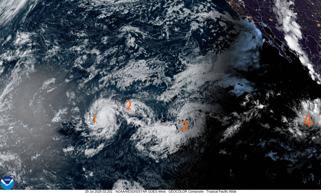
We have a lot to unpack here. We’ll go west to east.
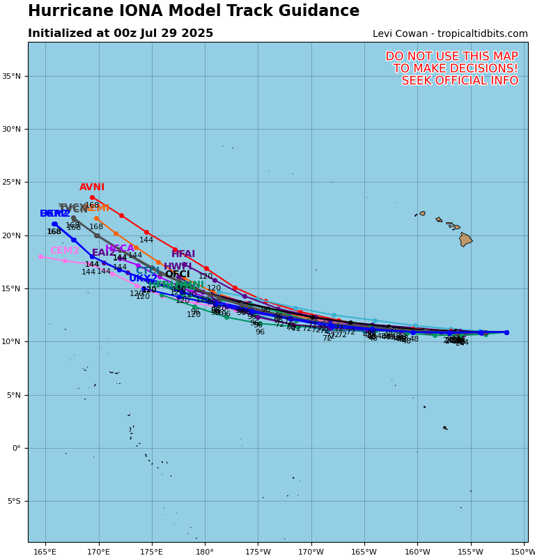
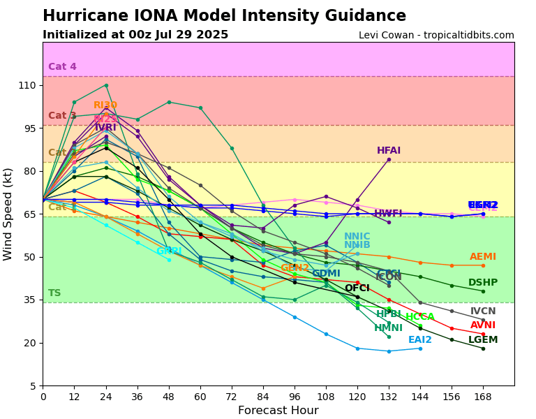
Hurricane Iona is currently Category 1, with 75 miles per hour sustained winds, central minimum pressure of 994 mb, moving west at 10 miles per hour. The storm is moving into an area that is somewhat conducive for tropical strengthening. Many models are indicating that this storm will strengthen, into a Category 2 or 3 perhaps, by midweek. The storm may weaken back down later this week as a ridge builds over the Pacific. It doesn’t look like it will impact land.
Tropical Depression Two-C has sustained winds of 40 miles per hour, with central minimum pressure of 1008 mb, moving west at 13 miles per hour. This storm will follow in the footsteps of Iona before it. Since it is following Iona so closely, it is less able to take advantage of the favorable conditions in the same area. It will likely strengthen into a Tropical Storm soon, but it probably won’t get much more intense than that.
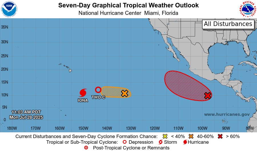
On top of this, two more regions are highlighted as potential development areas. One area is due east of Tropical Depression Two-C, and is similarly moving west. The conditions in the area are, like with the other storms, somewhat conducive to development, but the two storms ahead of it will put a damper on things. But, this storm may not have to deal with as much wind shear or warm air aloft as the storms before it. If it forms, it would likely be more intense than Depression Two-C at its peak, but not as strong as Hurricane Iona at its peak. The NHC has given this area a 60% chance of developing a tropical storm.
Finally, way to the east, to the south of Mexico, there’s another area of interest. Unlike the other storms, this system is moving northwest. The conditions for this system are the most favorable, with more moisture, less upper-air subsidence, and less wind shear. The NHC is giving this area a 90% chance of spawning a tropical system, and I agree with that. Once the storm forms, the center of circulation will be off the Mexican coast, moving parallel to it. Outer rain bands could very well impact mainland Mexico, causing a flooding and mudslide risk. Rapid intensification is a possibility with this storm, so it’s worth keeping an eye on.
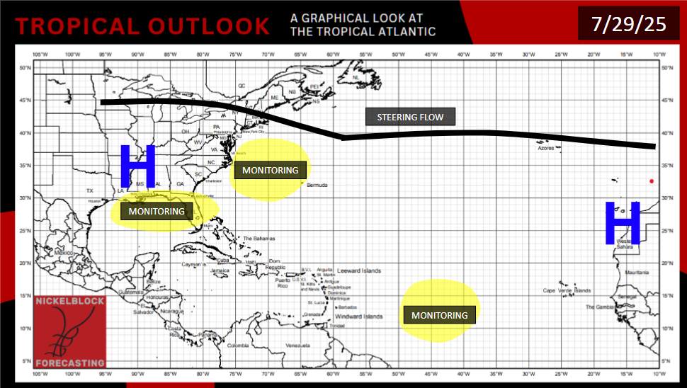
OTHER AREAS TO EXAMINE
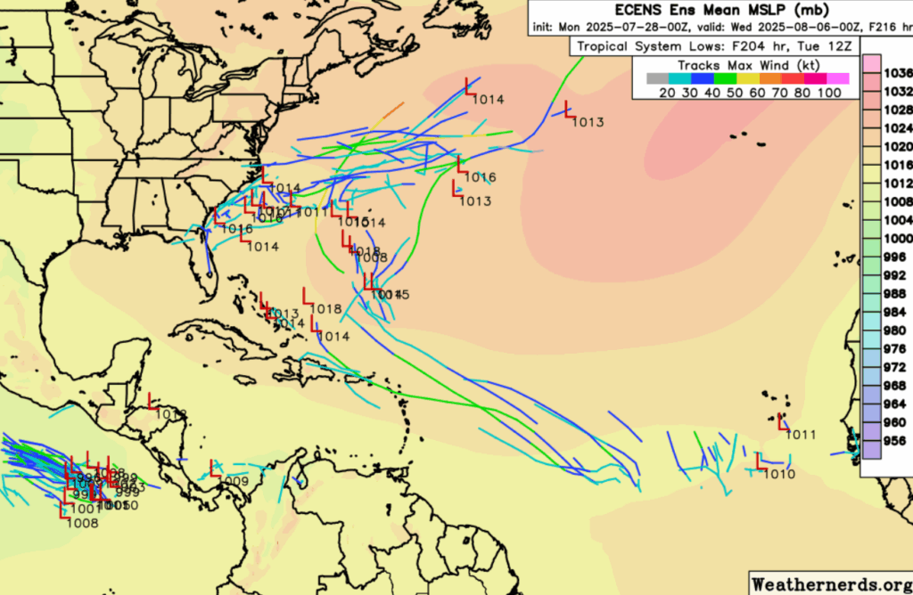
Some ECENS model ensembles pinpoint areas to watch in the Atlantic.
The GFS along with ECENS does want to spawn a storm off the Carolina coast. However, wind shear will be a massive issue for these storms. If they form, they will likely be short lived before the shear tears them apart. But perhaps some rainy and windy days are in store for the Carolina and Virginia coasts this weekend.
The Tropical Atlantic may awaken soon as ocean waters warm. A recent ECMWF run shows a system forming in the 10-14 day time frame, as a tropical wave catches a break in the African dust and wind shear. The surrounding environment will be pretty dry, however. If a storm does indeed form, it would either head west towards the Caribbean, or more northwest to more ocean, depending on the strength and location of the Bermuda High.
The WPC also is giving a 20% chance of tropical development in the next 7 weeks, in an area stretching from Jacksonville, Florida to Houston, Texas, across the gulf. This isn’t majorly supported in the model runs, but an area of low geopotential heights in the area means that the potential is there.
Going back to the Pacific, it’s likely that conditions will remain favorable enough to spawn one or two more tropical storms in the 7-14 day time frame. These storms would likely follow a similar path to most other storms this year, parallel to the Mexican coast, giving some rain and wind to areas along the Pacific coast of Mexico.


