Not tough times, trough times: The trough to our north will ensure conditions today remain unremarkable, with warm temperatures and a low rain chance. But perhaps in the heat and storminess of the Mississippi summer, a boring weather day isn’t the worst thing. Starting tomorrow, the pattern will shift, allowing for above average temperatures. Regretfully, rain probabilities will increase this weekend.
TODAY

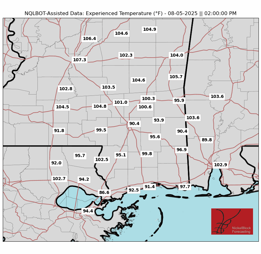
In addition to the trough, a stationary front lies to our South just off of the Gulf coast. These features are locking in a mass of drier air that is limiting thunderstorm coverage, with rainfall chances below 30%. The best chance of rain will be closer to the Gulf coast, where the stationary front may provide a lifting mechanism for storms. High temperatures will reach around 90 degrees. The drier air and a light breeze from the north or west will keep apparent temperatures at 105 degrees at the very most, lower in places with cloud cover.
REST OF THIS WEEK AND WEEKEND
Beginning Wednesday and lasting into Thursday, the trough will be replaced by a ridge. The stationary front will leave, allowing more moisture to seep into the area, increasing precipitation potential. But the ridge itself will limit upward convection, keeping Wednesday and Thursday afternoons from being total washouts.

When I speak of a ridge, I am technically speaking of the combined effect of two ridges. Our area will be in between the ridge on the Eastern Seaboard and another ridge in the Interior West. Both ridges will act as “heat domes”, and some of that heating effect will rub off on our area, allowing high temperatures to approach the mid 90s. Any breeze will be light and variable, allowing apparent temperatures to rise as the week goes on.
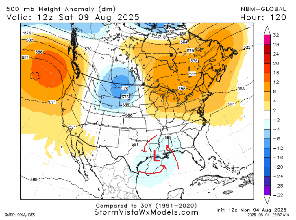
On Friday, another trough will form, initially to our north, then move southwest into the western Gulf of Mexico. The effects of this trough won’t be apparent at first, but remember that troughs mean low pressure, and that winds around a low pressure rotate counter clockwise. So as this trough moves into the Gulf, it will advect moisture from the Gulf of Mexico. This will likely blow the door open from a rain perspective, causing a rainy day this weekend, more likely on Saturday than Sunday. High temperatures will be in the low 90s.
NEXT WEEK
Signals such as models, teleconnections, and height anomalies suggest that, early next week, temperatures will be slightly above average, with highs in the low to mid 90s, as the ridge to the east re-asserts itself over our area. The CPC has a very slight lean towards above average precipitation, likely as a result of the slight chance of tropical activity along the Gulf coast. In the likely scenario no storm enters the Gulf basin, expect a more average rainfall coverage, with rain chances between 30% and 40% each day.
A LOOK TO THE TROPICS
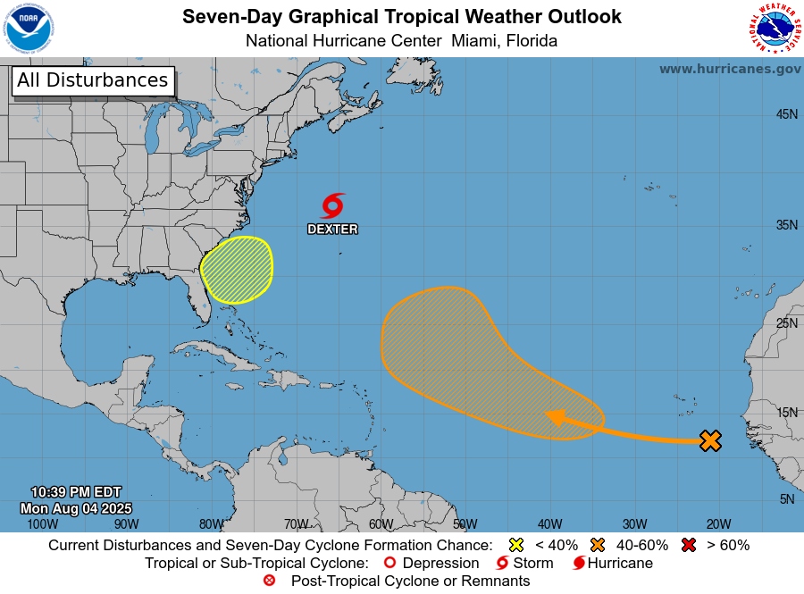
The Atlantic basin looks like it’s ready to fire up. Tropical Storm Dexter has formed well off the Carolina coast, but will be steered safely away from land and towards conditions that will lead to its demise. There are two areas of interest, you have the yellow one that could cause rainy times in the Carolinas this weekend, and the big orange one that seems likely to send a storm – somewhere. It is very tricky to pinpoint an exact location as the tropical wave that could become a storm has just recently moved offshore. We will get more specific as the week goes on, but for now, anywhere from Lake Charles to Havana to Cape Cod remains a possible landfall location, if it even landfalls at all.
REGIONAL DAY-TO-DAY FORECAST
Today: Partly cloudy. Highs around 90. Chance of rain 30%. Wind around 5mph.
Tonight: Mostly clear. Lows in the mid 70s.
Wednesday: Partly cloudy, chance of an afternoon thunderstorm. Highs in the low 90s. Chance of rain 40%. Wind around 5mph. Lows in the mid 70s.
Thursday: Partly cloudy, chance of an afternoon thunderstorm. Highs in the low 90s. Chance of rain 40%. Wind around 5mph. Lows in the high 70s.
Friday: Mostly cloudy, chance of an afternoon thunderstorm. Highs in the low 90s. Chance of rain 40%. Lows in the mid 70s.
Saturday: Rain and thunderstorms. Highs in the low 90s, lower in areas that get an early afternoon storm. Chance of rain 60%. Lows in the mid 70s.
Sunday: Rain and thunderstorms in the morning and afternoon. Highs in the high 80s. Chance of rain 50%. Lows in the mid 70s.
Monday: Partly cloudy, chance of an afternoon thunderstorm. Highs in the low 90s. Chance of rain 40%. Lows in the mid 70s.
Tuesday: Partly cloudy. Highs in the low to mid 90s. Chance of rain 30%. Lows in the mid 70s.
Wednesday: Partly cloudy, chance of an afternoon thunderstorm. Highs in the low to mid 90s. Chance of rain 40%. Lows in the mid 70s.
Thursday: Partly cloudy, chance of an afternoon thunderstorm. Highs in the low to mid 90s. Chance of rain 40%. Lows in the mid 70s.


