Afternoon heat and Gulf moisture fuel pop-up storms early in the week, with quick downpours, gusty winds, and lightning from August 5th to 7th. From August 8th to 11th, storm coverage expands as an upper-level trough boosts rainfall and increases flash flooding risks. Cloudier skies bring modest relief, but the humidity stays high and the summer rhythm rolls on.
Afternoon Thunderstorm Roulette: Aug 5th to 7th
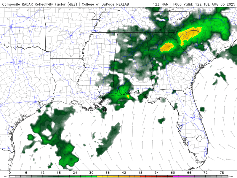
Radar for Tuesday through Thursday from the NAM model. //Courtesy: College of DuPage
From August 5th to 7th, the Deep South enters a stretch governed by classic convective instability, as intense daytime heating collides with deep Gulf moisture to prime the atmosphere for volatile afternoon storms. Mornings begin quietly, though humidity levels remain oppressive, with dew points sitting in the upper 70s°F. By midday, the sky begins its daily transformation, towering cumulus clouds signal rising instability without the influence of strong frontal systems; this is pure heat-and-moisture-driven convection. Between 2 and 6 p.m., isolated to scattered thunderstorms blossom quickly and without much warning, often delivering short-lived but punchy weather impacts, including brief downpours, wind gusts reaching 30 mph, and frequent cloud-to-ground lightning. Rainfall distribution is unpredictable; some areas stay bone dry while others contend with fast accumulations that can overwhelm urban drainage systems, leading to temporary street flooding. For anyone with outdoor plans, the window between late afternoon and early evening becomes a gamble, as these pop-up storms can swiftly derail even the best-laid itineraries.
Widespread Storms & Flooding Risk: Aug 8th to 11th
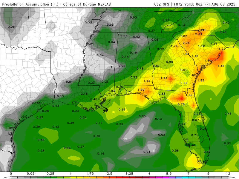
Precipitation accumulation 8/8 to 8/11 from the GFS model. //Courtesy: College of DuPage
From August 8th to 11th, a subtle but significant atmospheric shift unfolds across the Deep South, as a weak upper-level trough dips into the region and enhances both vertical lift and moisture convergence. This setup boosts overall instability, while thickening cloud cover tempers daytime heating just enough to moderate high temperatures into the upper 80s to low 90s. Despite the slight cool-down, moisture levels remain elevated, with precipitable water values climbing above 2 inches, a signal of rich atmospheric potential for rainfall. As a result, thunderstorms grow more widespread and consistent, especially during late afternoon and evening hours. Unlike earlier in the week, these storm cells are slower-moving, which allows for more efficient rainfall accumulation; many areas can expect totals of 0.5 to 1 inch, with isolated zones potentially exceeding that. The increased storm coverage introduces a heightened risk of localized flash flooding, particularly in low-lying or poor-drainage areas, while lightning and gusty winds pose threats to outdoor activities and travel plans.
Regional Day-to-Day Forecast
Tuesday – Mostly sunny with isolated afternoon storms. Highs 91–95°F. Humid with dew points in the upper 70s°F. West winds 5–10 mph. Storms may bring brief downpours and gusty winds.
Tuesday Night – Mostly clear. Lows 74–78°F. Light winds. Coastal showers possible.
Wednesday – Sunny and hot. Scattered afternoon storms. Highs 96–99°F. Heat index near 108°F. Southwest winds 5–10 mph.
Wednesday Night – Clear inland, partly cloudy coast. Lows 75–79°F. Light winds. Isolated coastal showers.
Thursday – Partly sunny. Afternoon storms likely near the coast. Highs 93–96°F. Heat index near 107°F. Light west winds.
Thursday Night – Mostly clear. Lows 75–79°F. Light winds. Slight chance of coastal showers.
Friday – Increasing clouds. Scattered storms late. Highs 88–92°F. Light south winds. Rainfall may exceed 0.5 inch.
Friday Night – Mostly cloudy with showers. Lows 76–80°F. Light winds. Flash flooding possible.
Saturday – Cloudy with widespread storms. Highs 87–91°F. Light winds. Rain totals may exceed 1 inch.
Saturday Night – Mostly cloudy. Scattered showers. Lows 77–81°F. Light winds. Flood risk continues.
Sunday – Overcast with storms. Highs 86–90°F. Light winds. Flash flooding possible.
Sunday Night – Cloudy. Scattered showers. Lows 76–80°F. Calm winds.
Monday – Mostly cloudy. Scattered afternoon storms. Highs 88–92°F. Light winds. Rainfall may be locally heavy.
Monday Night – Partly cloudy. Lows 75–78°F. Light winds. Isolated showers.
Tuesday – Partly sunny. Isolated storms possible. Highs 90–94°F. Light winds. Lower flood risk.
Tuesday Night – Mostly clear. Lows 74–78°F. Calm winds. Dry conditions expected.


