The main story in the tropics is Hurricane Erin, a storm that is remarkable in many aspects. Erin reached Category 5 status on Saturday, after extreme rapid intensification that outpaced even the most bullish model runs from the previous day. Central pressure dropped an unbelievable 79mb in 24 hours, as a “pinhole eye” formed and convection began in the eyewall, a sign the storm was taking advantage of near-prefect conditions. Storms like this are humbling, important reminders that models as they currently stand are nowhere near being able to accurately forecast rapid intensification. Despite the fact that Erin’s center stayed over 125 miles north of Puerto Rico, flooding and power outages were reported on the island. Similar conditions will occur in Turks and Caicos and the Bahamas today.
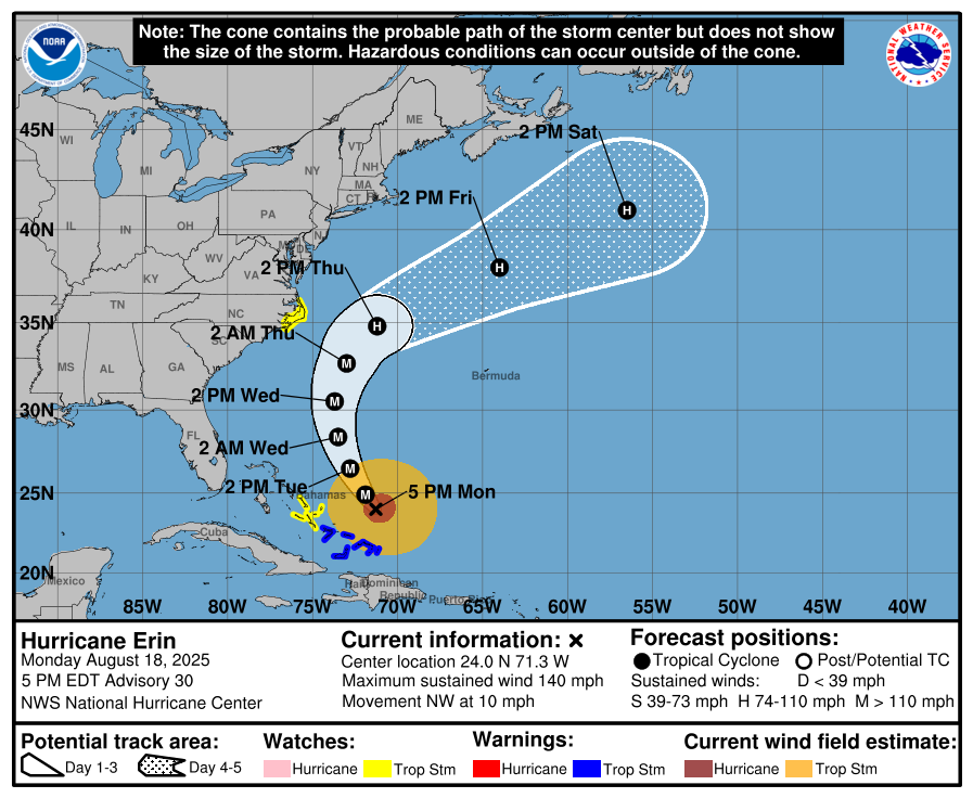
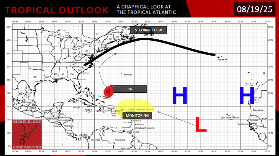
An eyewall replacement cycle led to Erin weakening to Category 3, but it has since re-strengthened to a Category 4. Maximum sustained winds are 140mph. Erin is about 400 miles east of Nassau, Bahamas, moving west northwest at 10mph, but it will soon turn and move in a more northerly and eventually northeasterly direction, as it will be steered by a pre-existing low pressure off the Virginia coast. The storm will slowly but surely weaken as it treks north over cooler waters.
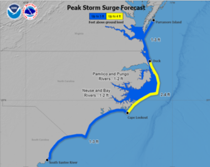
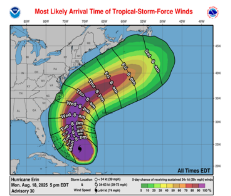
While the models have not predicted the storm’s intensity accurately, they have a good grasp on its future path. Erin’s center will stay over open ocean water for the rest of its life span. But due to the storm’s large size, it will create dangerous wave conditions along the East Coast. Parts of Dare County, North Carolina, in the Outer Banks, are under evacuation orders for storm surge, even though the storm is hundreds of miles offshore. A bridge in the county may become submerged, cutting contact with Hatteras Island. Tropical storm force winds (>39mph) may also occur in the Outer Banks Wednesday night into Thursday morning.
Every beach along the Atlantic coast will see more intense waves and a higher risk of rip currents. If you are in a coastal community this week, be sure to follow directions from local authorities. If you go swimming in the ocean, regard the flags on the beach that signal water safety, and consider not going in altogether if conditions are rough. Prepare for the possibility of flooding if you’re in the immediate vicinity of the ocean.

A SECOND AREA TO WATCH
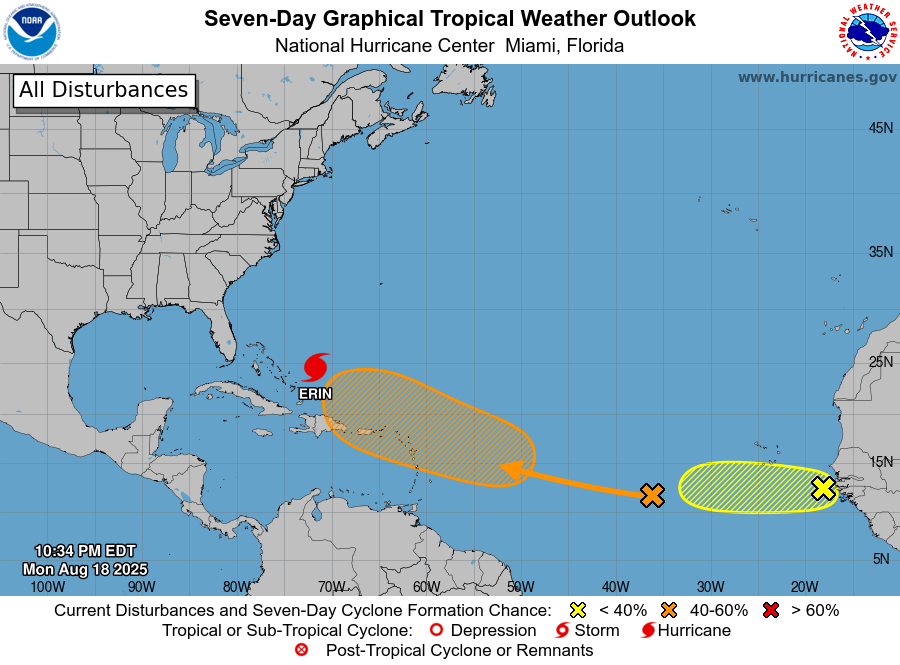
Behind Erin, just south of the area where her rapid intensification occurred, another area of interest lies, as a tropical wave will move in. The presence of the Caribbean islands may interfere with tropical formation. Where exactly the center of low pressure is will matter a lot, and differences of even 50-100 miles will make a big difference in determining if a storm can get going. The NHC is giving this area a 60% chance of generating a tropical storm in the next 7 days.
It is also not clear, if a storm forms here, where it will go. The GFS is very giddy to form a hurricane and slam it somewhere in the Southern United States in the 10-14 day time frame, while the more cautious European model is laying off. Looking at the ensembles however, what seems more likely is that this future storm will take a similar path to Erin, staying away from the U.S. mainland. Moisture looks decent, water temperatures are high, and wind shear doesn’t look too intense in the Gulf of Mexico and off the Florida coast at this point, three factors good for tropical development. So, this storm could get pretty intense, not as intense as Erin, but a major hurricane forming wouldn’t shock me.
The yellow tropical wave on the map above is only being given a 10% chance of spawning a storm. If one forms, it would only last for a day or two before moving into an area of lower moisture and high shear left in the wake of the other tropical wave discussed above.
FUTURE AREAS OF DEVELOPMENT
In the Atlantic, there is a weak model signal for a tropical system to form in the Gulf of Mexico in the 7-14 day time frame. Favorable conditions for tropical weather exist if a low pressure can find its way there.
Wind shear may be abating in the Pacific Ocean south of Mexico, so another storm forming here would not be a surprise either, especially with the moist environment and untapped warm ocean waters.


