While the end of meteorological summer is in sight, conditions today will resemble the dog days. A trough to our north will bring in wetter and milder conditions starting Thursday, setting the stage for a more rainy weekend.
TODAY

We are under a regime of high pressure, which will limit coverage of afternoon thunderstorms today. This will allow the sun to make things quite warm, with high temperatures in the mid to high 90s this afternoon. There is plenty of moisture in the area, allowing apparent temperatures to reach up to 110 degrees. Relief from wind breezes will be minimal.
REST OF THIS WEEK

A cold front over the Midwest will slowly move south. While this front itself doesn’t quite look like it will reach our area, it’s presence to the north will weaken the effects of the high pressure, increasing the risk of rain. A northerly breeze combined with the rain will revert temperatures to normal levels starting Thursday.

Wednesday will not be too different from Tuesday, but the chance of rain will be higher, and a weak squall line is possible as well. Storms are expected to be sub-severe, although conditions are favorable for downbursts which could pack some gusty winds.
Rain chances will meaningfully increase on Thursday, with thunderstorms likely in the afternoon and perhaps a squall line moving through in the early evening. Chance of rain will be north of 60%. On Friday, we expect things to cool down even more as a northwesterly breeze asserts itself. Temperatures may not even exceed 90 in many places. Chances of rain will remain around 60%.
WEEKEND
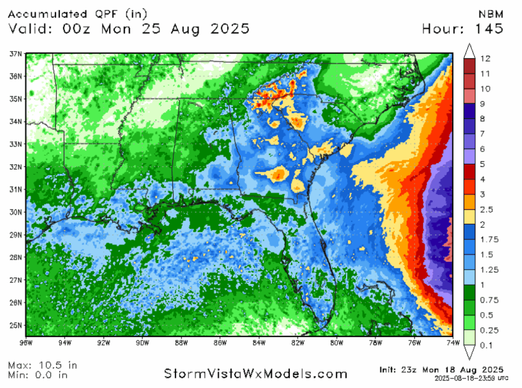
Looking to the weekend, the wind will shift back to being from the south, ushering in moisture from the Gulf of Mexico. That combined with increase atmospheric lift will keep rain chances above 50%. Temperatures will return to more normal levels, with highs in the low 90s. All told, most areas will see between 0.75″ and 1.25″ of rain from today until Sunday evening. This alone wouldn’t be enough to produce flooding, but it’s possible some localized areas that get thunderstorms multiple days in a row may see minor flooding.
NEXT WEEK
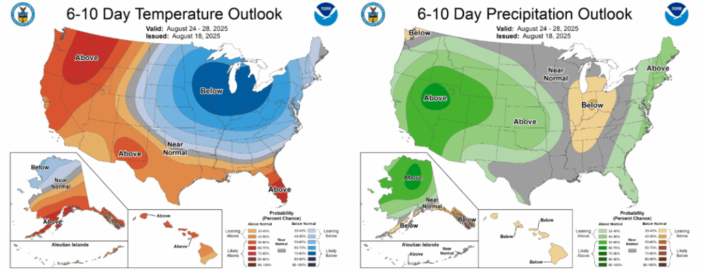
A big time trough will be in place over the Great Lakes region, and the periphery of this ridge will encroach on our area at times, keeping temperatures from getting too warm. Teleconnections are also suggesting more average temperatures, which for this time of the year is around 90 degrees. For precipitation, on the one hand, the trough will cause winds to blow from the north over land, preventing some Gulf moisture from causing rain. On the other hand, troughs allow for more rising air, allowing more convection. I’d expect a 30-40 percent chance of afternoon thunderstorms most days next week.
A LOOK AT THE TROPICS
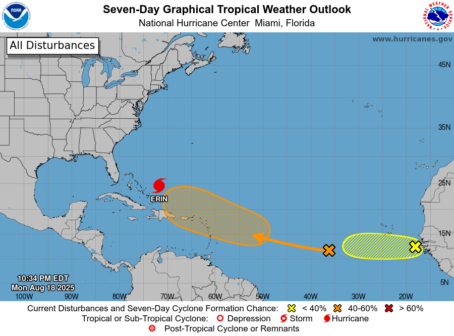
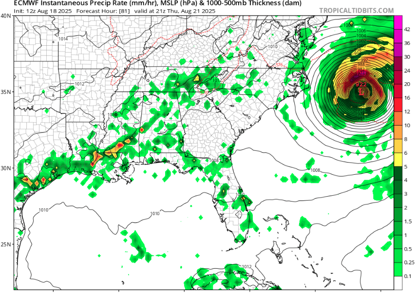
Hurricane Erin is currently a Category 4 located north of Haiti. It is currently moving northwest, but it will turn due north and then northeast out to sea. While the storm’s center will remain offshore, it’s sheer size will mean that heavy waves, rip currents, and even storm surge will impact the East Coast of the United States, as well as the Bahamas. Hatteras Island in North Carolina has been evacuated, as there are fears that storm surge will submerge the only bridge in and out of the island.
Some models are also showing a hurricane in the Gulf of Mexico in the 10-14 day time frame, potentially originating from the tropical wave marked with the orange “x” in the map above. While this isn’t the most likely outcome, the conditions do exist for a storm to form in the Gulf if a low pressure can form. Stay tuned to Nickelblock Forecasting and the NHC for updates.
The yellow area of interest may also spawn a storm for a short period of time. It would stay over the open ocean for it’s entire lifespan.
DAY-TO-DAY REGIONAL FORECAST
Today: Mostly sunny. Highs in the mid to high 90s. Humid. Winds light and variable.
Tonight: Mostly clear. Lows in the mid 70s.
Wednesday: Mostly sunny, chance of an afternoon or evening thunderstorm. Highs in the mid to high 90s. Chance of rain 30%. Lows in the mid 70s.
Thursday: Partly cloudy, chance of an afternoon or evening thunderstorm. Highs in the low 90s. Chance of rain 60%.Winds from the northwest at 5 mph. Lows in the mid 70s.
Friday: Partly cloudy, chance of an afternoon or evening thunderstorm. Highs around 90. Chance of rain 60%. Winds from the northwest at 5 mph. Lows in the mid 70s.
Saturday: Partly cloudy, chance of an afternoon thunderstorm. Humid. Highs in the low 90s. Chance of rain 60%. Winds from the southwest at 5mph. Lows in the mid 70s.
Sunday: Partly cloudy, chance of an afternoon thunderstorm. Humid. Highs in the low 90s. Chance of rain 50%. Winds from the southwest at 5mph. Lows in the mid 70s.
Monday: Partly cloudy, chance of an afternoon thunderstorm. Highs in the low 90s. Chance of rain 50%. Lows in the low 70s.
Tuesday: Partly cloudy, chance of an afternoon thunderstorm. Highs in the low 90s. Chance of rain 30%. Lows in the low 70s.
Wednesday: Partly cloudy, chance of an afternoon thunderstorm. Highs in the low 90s. Chance of rain 30%. Lows in the low 70s.
Thursday: Partly cloudy, chance of an afternoon thunderstorm. Watching the tropics. Highs in the low 90s. Chance of rain 40%. Lows in the mid 70s.


It’s so refreshing to read a no nonsense weather forecast. Derek puts the weather forecast into “Keep it simple terms”. Thanks
Thank you for the kind words Joey!
Great job!!