Communities up and down the U.S. East Coast have experienced storm surge from Hurricane Erin. Today, Long Island and coastal New England will be affected by winds and surge. But the good news is that Erin is moving quickly to the east, and won’t be a problem by the weekend. Once Erin departs, the U.S. coasts should be safe from hurricane impacts for the next 14 days at minimum.
NOTES ON ERIN
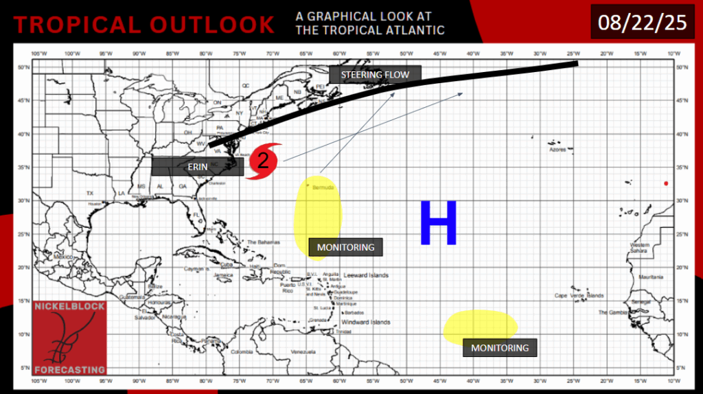
Hurricane Erin remains a Category 2 off the coast of Virginia. You may have seen videos of inundation of coastal areas of North Carolina and Virginia, with abnormally high waves crashing into buildings right next to the beach. Many homes and businesses are in precarious situations. A lot of homes in the area are built on top of stilts to mitigate risks from storm surge. These measures are being tested right now.

The most impressive element of this storm for me is that there is a surge issue in the first place, despite the fact that the storm’s center is around 350 miles from land, and the tropical storm force wind field didn’t even reach most coastal areas. The hurricane’s massive size, with said wind field being over 500 miles across, a number most hurricanes would envy, is allowing storm surge to impact places that didn’t otherwise see any wind or rain from Erin. Maryland, Delaware, and New Jersey also experienced some coastal flooding impacts, but not to the extent of Virginia and North Carolina.
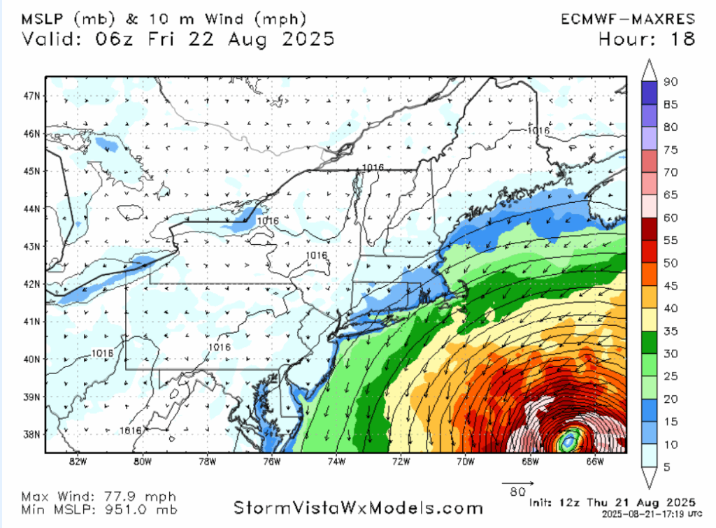
Some locations on Long Island and southern New England could experience heavy wind gusts, potentially barely above tropical storm criteria (40 mph), this morning or early afternoon. Anyone on the East Coast from the Carolinas up to Maine should avoid swimming in the ocean today due to the risk of rip currents.
The good news is that Erin is picking up speed and moving to the Northeast. By Saturday morning, all of Erin’s effects will be safely over the open Atlantic.
A MESS IN THE ATLANTIC
There are three areas of interest in the Atlantic Ocean, and in the Pacific Ocean. Let’s break it down.

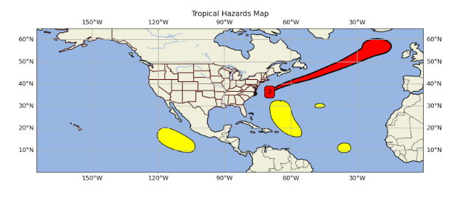
The most prominent of these is Invest 90L. The NHC is giving this area a 70% chance of giving rise to a tropical system. Light shear and ample moisture will allow the storm to strengthen once it forms. Models suggest a peak intensity of high-end Category 1 or low-end Category 2. Interestingly, the enormity of Hurricane Erin may stop this system from getting more powerful, as persistent cloud cover has kept sea surface temperatures in the area a few degrees lower. Earlier this week, some models had this storm continuing east and impacting the southeastern U.S. coast. The steering mid-atmosphere winds saw that and said, “Not if we have anything to say about it, and we do”!

The low pressure and stationary front to the storm’s north will ensure this storm takes a northerly direction, and eventually a northeasterly one. The storm could impact Bermuda Sunday night into Monday, and potentially Newfoundland on Wednesday, perhaps as a post-tropical cyclone at that point. People in those areas should remain vigilant.
The two other areas of interest in the Atlantic will just be “fish storms”. The area of interest furthest southeast is running out of time to form. The tropical wave will get a bit too close to the Equator and run out of Coriolis force this weekend. The conditions do currently exist to allow this wave to become a tropical depression or weak tropical storm. Looking at the satellite, there’s a vague center of circulation. It’s not the most organized, but this system is also small, so it could develop quickly. The NHC is giving this wave a 50-50 shot of becoming a tropical depression or storm. I don’t like to be a fence sitter, so I’ll lean very slightly in favor of a storm forming.
There is a tiny area of interest in the middle of the Atlantic. Candidly, I don’t know what the NHC is seeing here. All the fundamentals needed for tropical formation, moisture, lack of shear, warm water, surface convergence and aloft divergence, are not especially present here. No model is showing anything forming here, even the more excitable ones. I don’t see anything that suggests there will be any formation here. The NHC is giving this area only a 20% chance of developing a depression or storm in the next two days.
PACIFIC
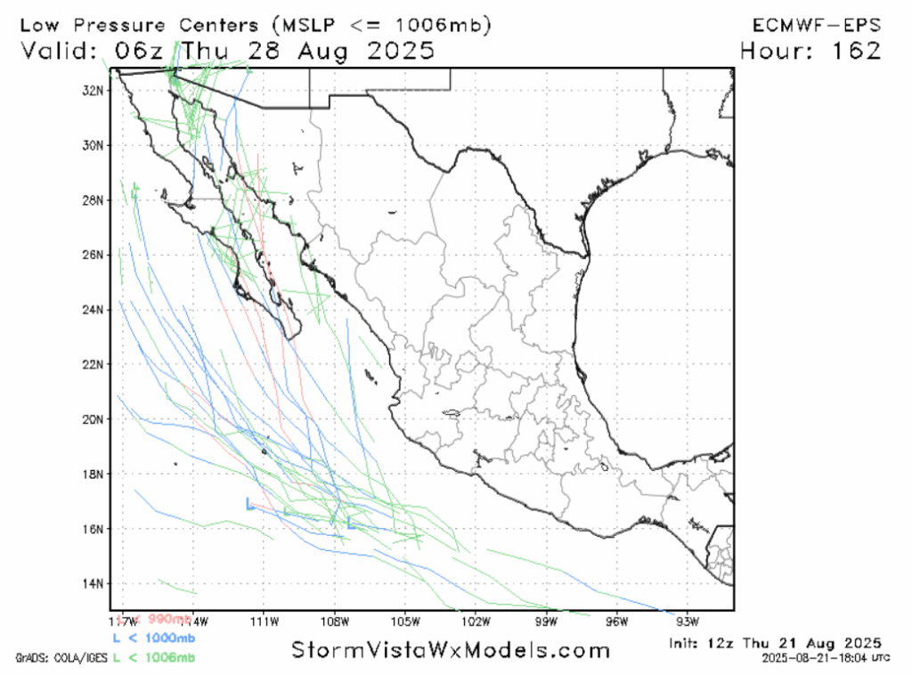
You know what we’re due for? Another Pacific storm that forms southwest of Mexico and follows the Mexican coastline. A break in the wind shear and some rich moisture will support tropical development early next week, just in time for a tropical wave to enter the area. Some model projections steer this storm out to sea, while others have it impacting the Mexican region of Baja California. It will depend on the steering patterns.
FUTURE DEVELOPMENT AREAS
In the 7-14 day time frame, another tropical wave could come off the coast of Africa and make use of the still favorable conditions in those waters as it moves to the east.
If wind shear continues to hold off, we could also see a second storm in the Pacific south or southwest of Mexico that would move parallel to the Mexican coast, staying offshore.
This was my last tropical outlook this summer, as my internship is coming to a close. Thank you to everyone who read one of my outlooks, this site has been a great platform to inform the public and learn new things myself. I hope you have enjoyed reading my outlooks as much as I enjoy making them.


