There are certain weather cliches in every region of the United States that people will claim are unique to their own area. Among those are the existence of “fool’s fall”, a short period of cooler than average temperatures that coaxes people into believing summer is over, only for stifling temperatures to return at some point in September. Really, there are few places in America that aren’t prone to a sequence like this, but as we’ll see, many in our area may fall victim to a fools fall next week.
TODAY
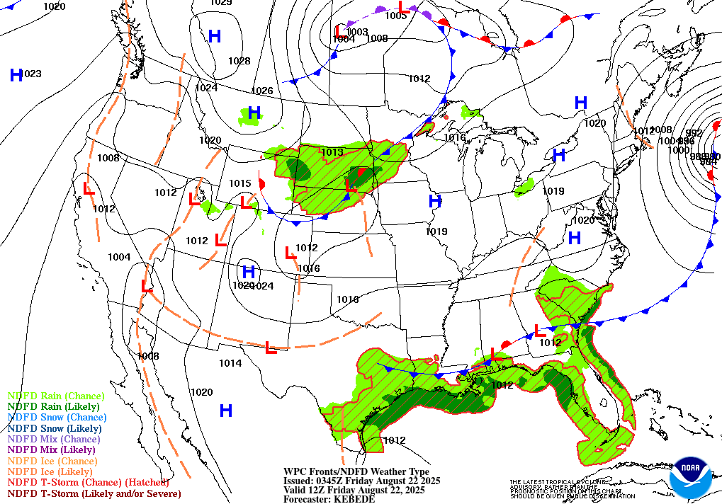
Over Mobile, Alabama lies a low pressure system. A cold front stretches from this pressure through the coastal counties of Mississippi, while a stationary front stretches the other direction. Fronts are lifting mechanisms, which, combined with moist air, will allow scattered thunderstorms this afternoon and evening along the frontal boundary. The exact placement of the front will matter a lot in determining who gets rain. Your chance of getting rain increases significantly if you’re below Route 84. Despite the cold front, high temperatures will remain average, around 90 degrees, as the front won’t actually move past our area. High temperatures may not reach 90 in places that get an early afternoon storm to cool things down. The front being almost stationary will keep winds low outside of thunderstorms, what little wind there is will be from the south. Some thunderstorms could be capable of producing sub-severe wind gusts of up to 50 miles per hour, as high instability values are in place. Storms should clear out pretty soon after nightfall.
THE WEEKEND
On Saturday, the pattern will evolve slightly, with the cold front being replaced with another stationary front. This changes the dynamics slightly, decreasing rain and thunder chances for the southern part of our forecast area. Besides that, expect similar rain conditions as Friday.

On Sunday, the front will likely depart the area, and drier conditions will take over, reducing rain chances to typical summertime levels.
NEXT WEEK – THE TROUGHENING
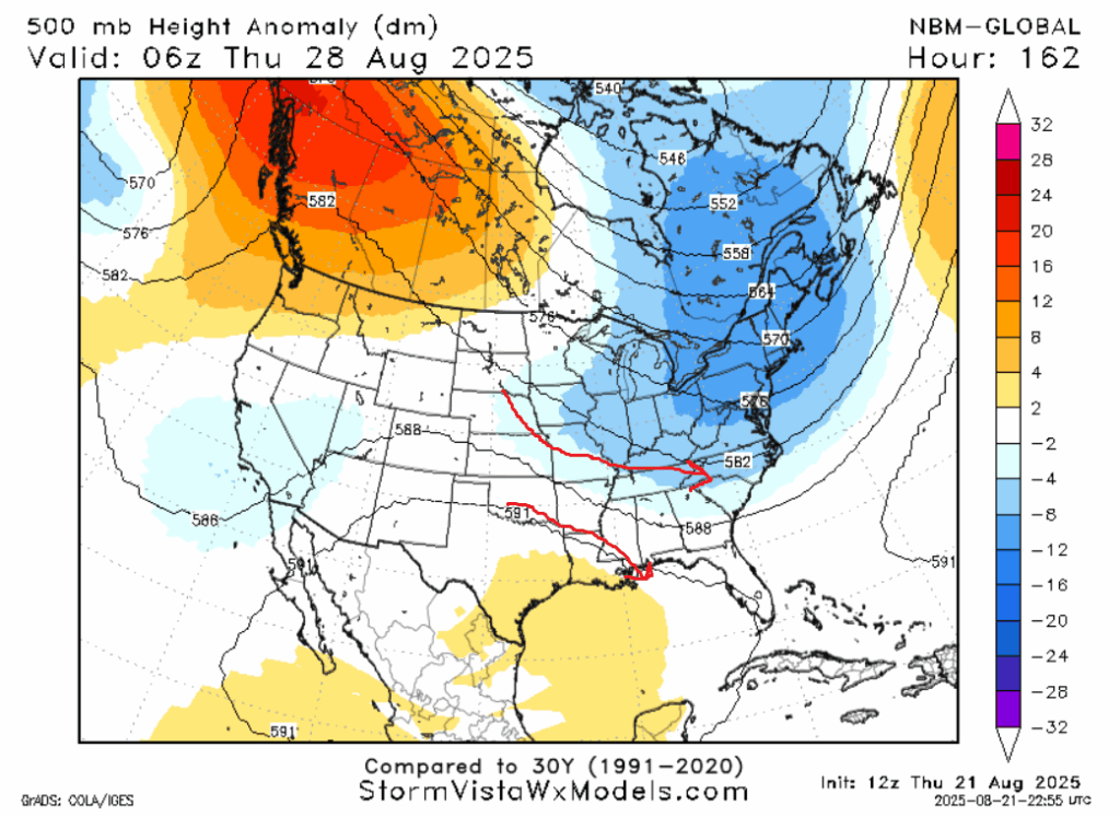
If you are weatherwise, you will likely soon hear about much cooler than average conditions in the Midwest. This is mainly driven by a very large trough that will settle in over that area. The guidance suggests that our forecast area will be on the periphery of this trough, between it and a much weaker ridge to the south. This setup will last throughout the week. Thursday and Friday look to be the coolest days as a ridge to our southwest will aid in funneling in cooler weather from the northwest as shown above. It’s possible the high temperatures won’t even crack 85 on either day. This is the “fool’s fall” I spoke of previously. It’s possible some more frontal activity will increase rain chances in the beginning of the week, but model composites seem to agree that rain chances will go down as the week goes on.
A LOOK AT THE TROPICS

Hurricane Erin is causing storm surge up and down the East Coast, with the worst impacts in North Carolina and Virginia, which saw tropical storm force wind gusts. Today, Long Island and New England are under the gun, but impacts there will be more limited. Erin will cease impacting the East Coast tonight. There are three areas of development in the Atlantic, each with a different probability of forming a storm, but models are in total agreement that none of them will have a direct impact on the United States. South of Mexico, a storm may form early next week that may eventually impact the Mexican region of Baja California if a few things break wrong, though that isn’t the most likely scenario.
REGIONAL DAY-TO-DAY FORECAST
Today: Mostly cloudy, chance of an afternoon thunderstorm, especially south. Highs around 90. Chance of rain 60%.
Tonight: Rain clearing out by 10pm. Lows in the mid 70s.
Saturday: Partly cloudy, chance of an afternoon thunderstorm. Highs around 90. Chance of rain 40%. Lows in the low 70s.
Sunday: Partly cloudy. Highs in the low 90s. Chance of rain 30%. Lows in the low 70s.
Monday: Partly cloudy, chance of an afternoon thunderstorm. Highs in the low 90s. Chance of rain 40%. Lows in the low 70s.
Tuesday: Partly cloudy, chance of an afternoon thunderstorm. Highs in the low 90s. Chance of rain 40%. Lows around 70.
Wednesday: Partly cloudy. Highs around 90. Chance of rain 30%. Lows in the high 60s.
Thursday: Partly cloudy. Highs in the mid 80s. Chance of rain 30%. Lows in the high 60s.
Friday: Mostly sunny. Highs in the mid 80s. Chance of rain under 20%. Lows in the mid 60s.
Saturday: Mostly sunny. Highs in the high 80s. Chance of rain under 20%. Lows in the high 60s.
Sunday: Mostly sunny. Highs around 90. Chance of rain 30%. Lows around 70.
ONE FINAL NOTE
This is my final forecast of the summer, as the internship comes to a close. I am thankful to Nick for providing me this platform to forecast weather for the public and learn so many new things myself. I hope you’ve enjoyed reading my forecasts as much as I’ve enjoyed putting them together for y’all. Always stay curious about the weather!


Awesome job!