Overall, weather conditions will be typical of those expected in early September this week with very warm daytime temperatures and mild overnight lows.. The “big cooldown” that a lot of folks have been posting about on social media looks less likely to impact us directly – and if so, it would be this next weekend.
But even then, it isn’t looking quite as robust. At least or us.

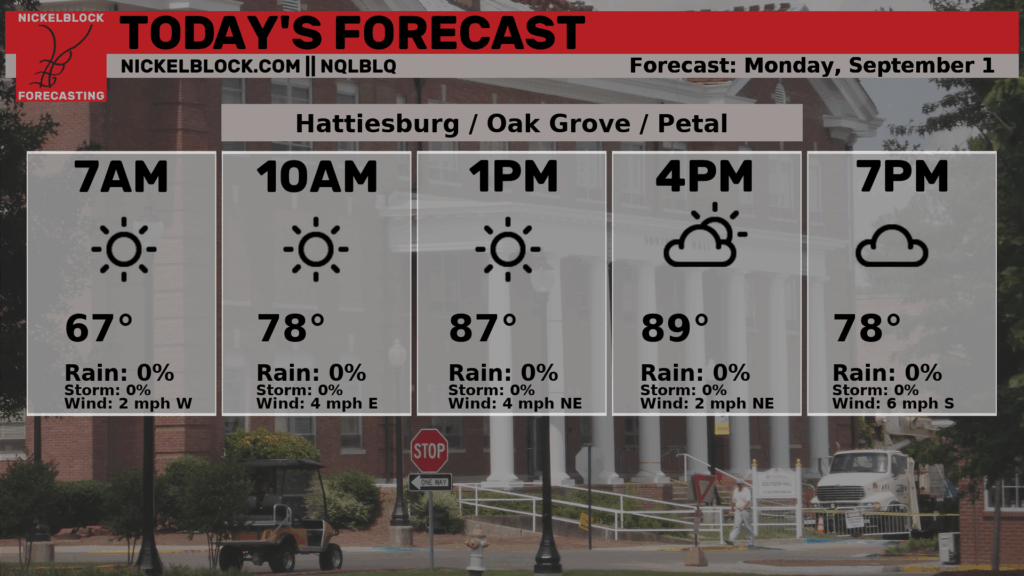
For folks in the Hattiesburg area, highs will top our around 90.

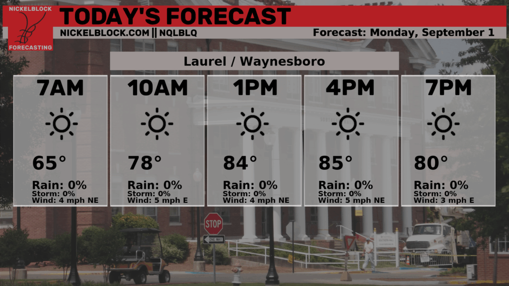
For folks near Laurel and Waynesboro, things may be a few degrees cooler.
Sow hat is the deal with the cool down? Well, a lot of folks that were pointing toward a big cool down were leaning on ont e amplified pattern shown in the guidance. below, on the left the ECMWF last week showed a sharper more pronounced trough across the Great Lakes and poked its nose all the way into the south. The kind of pattern that was shown would hav ebeen highly anomalous.
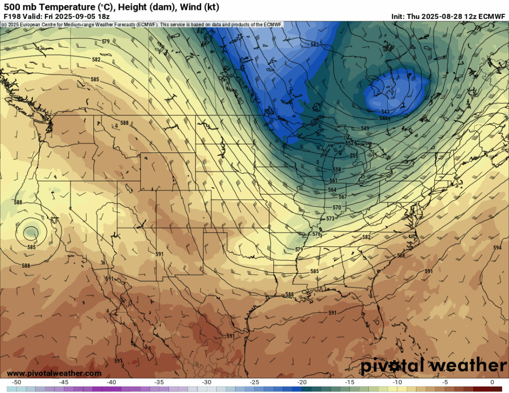
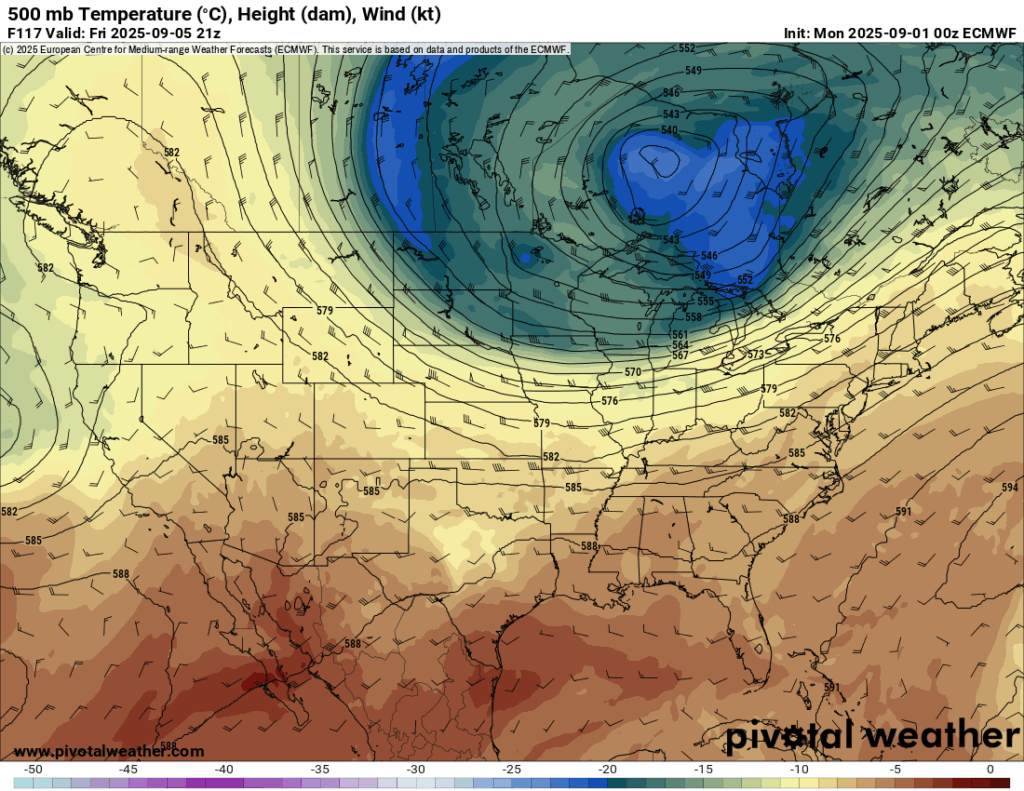
As it stands, the current forecast for the 500mb maps, shown above on the right, is still pretty anomalous. Upper-level heights in the core of this trough will be about 2-4 standard deviations below normal for this time of year. But the more zonal flow for our area means that we may not be impacted quite as much by the cooler temperatures.
This was expected. The “First Fall Cold Front” is always unlikely to arrive on Labor Day. Usually we have to wait until October 10th (ish).
s noted by the NWS in Jackson, “The broad trough axis over the eastern half of the country still means disturbances could bring some chance for showers or storms to the region, and Tuesday into Wednesday currently looks to be the best time range for that to occur with a passing shortwave through within the broader longwave trough. Timing and strength of the wave details could adjust this window for rainfall.”
Meanwhile, out in the Tropics, the NHC is monitoring the next wave. Now showing a “medium” chance for development. This one is a big of question mark still.

If it can stay south and sneak into the Caribbean it may be something we have to monitor closer, but for now a lot of the model guidance wants to curly-cue it northward and have it remain out to sea.
REGIONAL DAY TO DAY FORECAST
Today: Sunny. Highs around 90. East winds 5 to 10 mph.
Tonight: Partly cloudy in the evening, then clearing. Lows in the mid 60s. East winds around 5 mph.
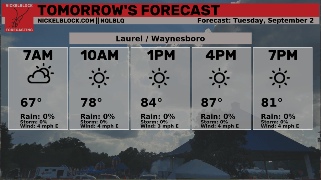
Tuesday: Sunny. Highs around 90. East winds around 5 mph.
Tuesday Night: Mostly clear. Lows in the mid 60s. Southeast winds around 5 mph in the evening, becoming light and variable.
Wednesday: Sunny. A slight chance of showers and thunderstorms in the afternoon. Highs in the lower 90s. Northeast winds around 5 mph, becoming southeast around 5 mph in the afternoon. Chance of rain 10 percent.
Wednesday Night: Mostly clear. Lows in the upper 60s.
Thursday: Sunny. Highs in the lower 90s.
Thursday Night: Mostly clear. Lows around 70.
Friday: Sunny. Highs in the mid 90s.
Friday Night: Mostly clear in the evening, then becoming partly cloudy. Lows in the lower 70s.
Saturday: Mostly sunny. A slight chance of showers and thunderstorms in the afternoon. Highs in the lower 90s. Chance of rain 20 percent.
Saturday Night: Partly cloudy. Lows in the upper 60s.
Sunday: Sunny. Highs in the lower 90s.


