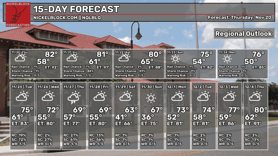
After a few mornings of some rather potent fog, it looks like we may start to shake out of this (after some rain) as we move through the weekend. The reason we have been dealing with the fog is a persistent southerly fetch pumping in Gulf of Mexico air. Couple that with long, clear nights, and we radiate all of the warmth from the day away and the temperature settles back and cools all the way back to the dewpoint temperature… and BAM! Fog.
TOMORROW
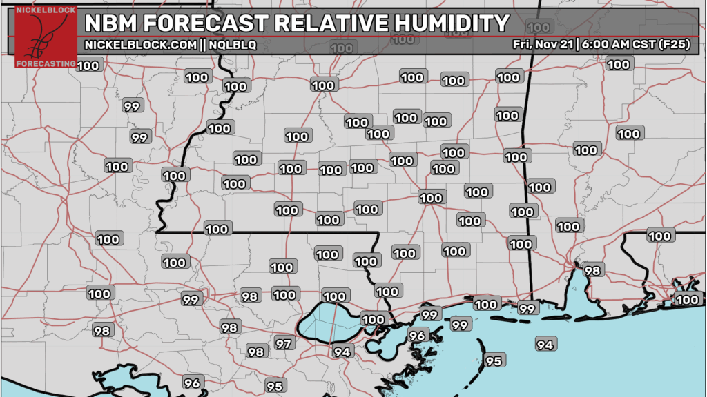
We will have one more morning of it tomorrow. The NBM Forecast model guidance for humidity tomorrow morning shows a good batch of 100s across the region.
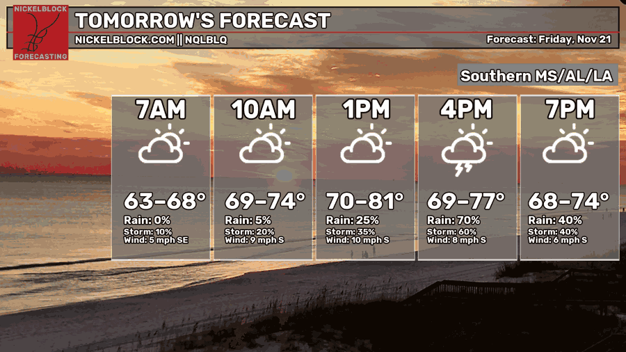
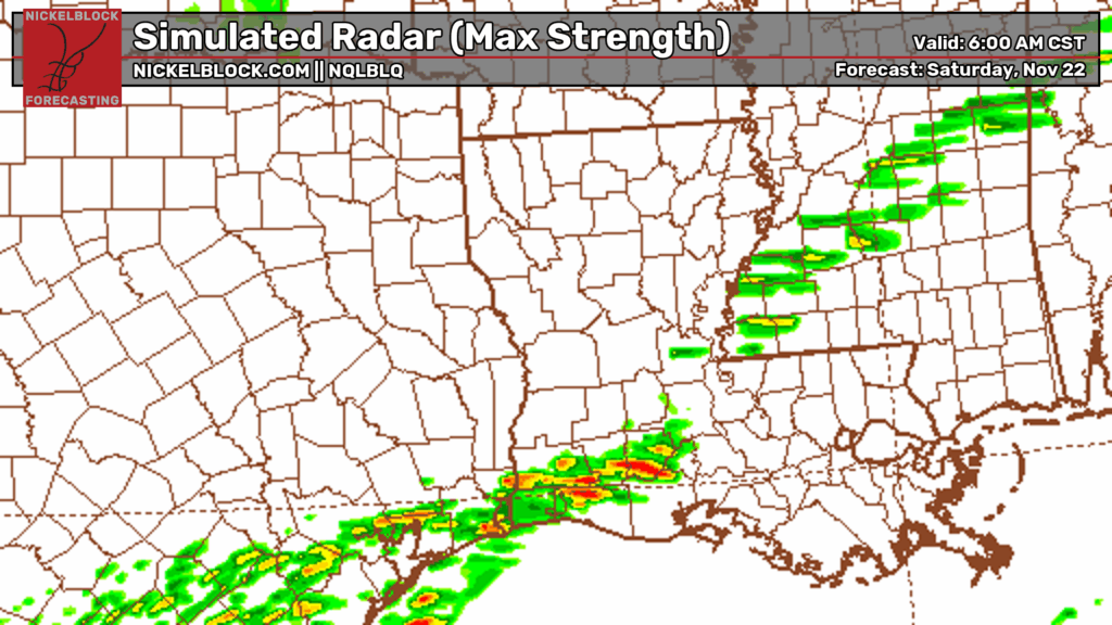
The fog will likely be cleared out by 10am again. And in some places, it will be cleared out by some rain and storms. We have a bit of an interesting disagreement between the models tomorrow. On the one hand, we have the Machine Learning driven data that supports a dry morning with a stormy afternoon as shown on the graphic below.

But then you look at some of the shorter-range model guidance and we see a chance for some rain and storms in the morning across most of southern Mississippi.
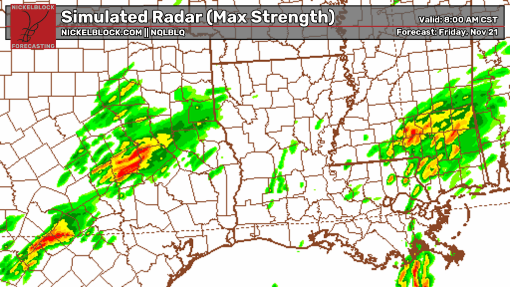
This map above showing the rain in the morning is the first I’ve seen of some of the shorter-range guidance developing storms in the morning hours. We did see some of this from the ECMWF and GFS models during the last few days, but they were waffling back and forth, themselves.
Even today, the ECMWF holds off on a good chunk of the rain until the afternoon hours. While the GFS shows some morning spotty showers and the more robust stuff in the afternoon.
Given all of that, and some other data I’ve reviewed, here is where I think we sit on a timeline of events:
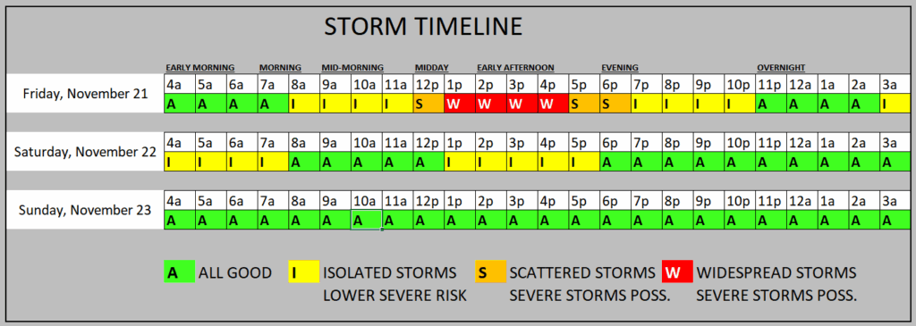
I don’t think we can rule out some isolated morning showers and storms, but the severe weather threat would be quite low in the morning and the rain is probably going to be hit and miss, and shouldn’t be as robust as the afternoon
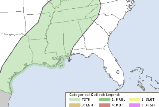
I think the better bet for rain arrives shortly after lunch. This will feature the outside risk for some stronger storms and a severe storm can’t be ruled out. So far the SPC has us in just the “General thunderstorms” category.

THIS WEEKEND
Beyond that, as we move into Saturday, there is a shot for some lingering rain in the morning to slide through. And then another few showers may try to pop up in the afternoon. This wouldn’t be much. Some heavy mist or light rain.
It looks much more robust on this map than it will likely end up being.
Then we dry out. Sunday looks dry. Monday, too.
NEXT WEEK
Then Tuesday, the next system arrives. This one may pack a bit more of a punch depending on how much arctic air it can tap into.
You may recall from all the rabble-rousers online that this was supposed to be the “BIG ARCTIC BLAST” but now it looks like it may be split into two systems. The main rain maker may be a Pacific-born front and the arctic air may show up later…. and swing to the east more than into the south.
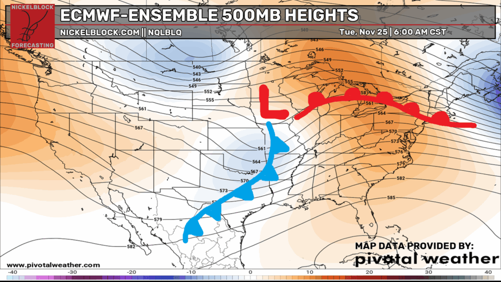
Either way, it looks like we will probably be able to shake out some storms from this system as it passes by on Tuesday and perhaps Wednesday.
The ECMWF Operational model shows the rain on our doorstep by Tuesday morning
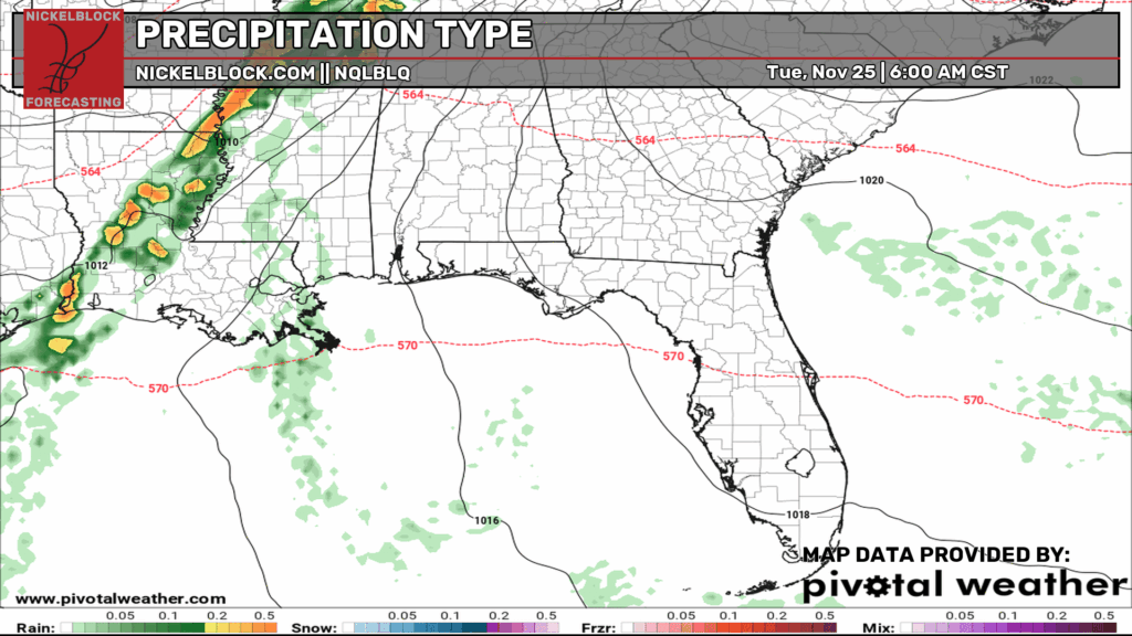
If this played out, it would be out of here by Tuesday night. Then we play the same song and dance again, as it looks, on Thursday and into Friday. Then we calm down again.
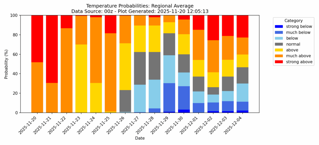
Notice how cold that big “arctic blast” is looking now…. lows in the mid 30s (a few degrees cooler than normal) and highs around 65 degrees (a few degrees cooler than normal).
Even the regional look at the temperature probabilities isn’t very impressed with the risk for things to get super cold.
LOOKING TOWARD CHRISTMAS
While we are still a week out from Thanksgiving, folks have already started to ask about Christmas. Well, we have some data to show a forecast, but know that this is a general outlook and while I can offer a specific number, the specific number isn’t quite as meaningful this far out.
But looking at the temperature chart, we can see that the clusters support a pretty typical range of temperatures between now and (roughly) the end of the year.
I have plotted the “outlier” clusters on here to give an idea about what some of the less-likely members support.
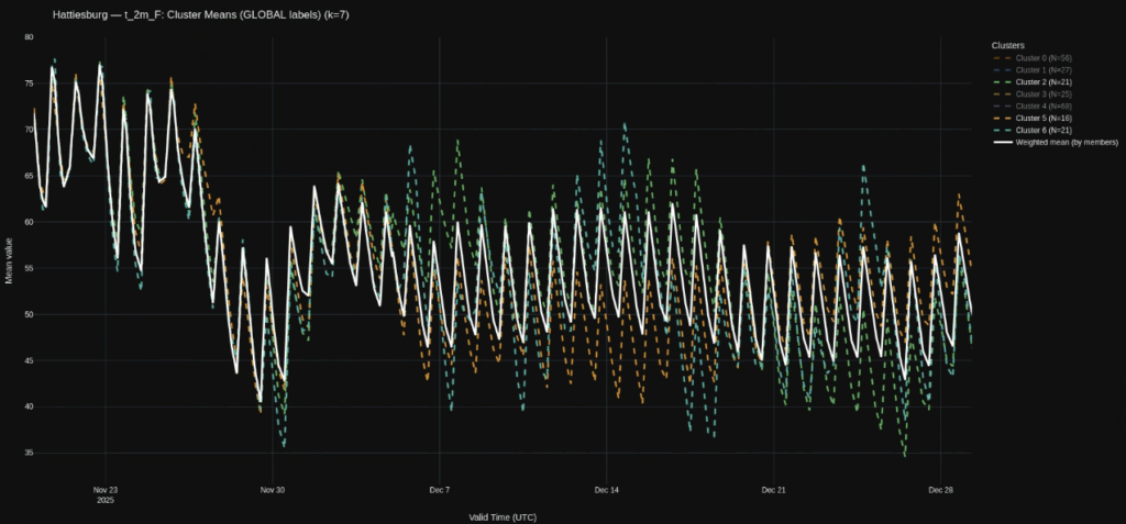
Notice that even these outliers don’t go terribly cold nor terribly warm. That said, there does appear to be a signal that we will get a bit cooler after Thanksgiving, then again around December 7th and again around Christmas.
But how much cooler is still TBD.
Speaking of Christmas, for those of you dreaming of a White Christmas in South Mississippi, the clusters currently show about a 7% chance that it snows on Christmas night.
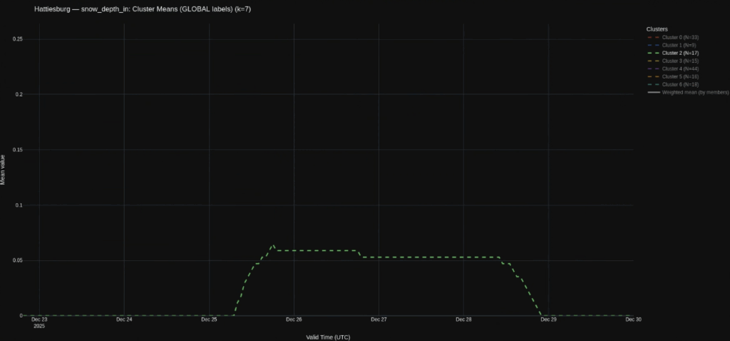
This is down from 12% a few days ago, but up from 2% about a week earlier.
So, still not very high. But also not zero. And historically speaking, we have a 0.2% chance for snow on Christmas. So, having some fun with this, mathematically, we can say, “Model guidance shows that the Pine Belt is 35-times more likely to see snow on Christmas this year than on any -normal- year.”
Though, again, right now it sits at just 7%.


