Our first severe weather event of the year! And, look at that, Mother Nature waited a whole week and change before delivering it! Ain’t she swell?
On a serious note, we do have a risk for storms and severe weather – including heavy rain, lightning, wind gusts up to 65mph, small hail and tornadoes – but the risk isn’t a slam dunk for everyone. Depending on how things shake out with a secondary push of warmer air, some folks may shrug their shoulders and say, “what storms?” when this is all said and done. While others will be dealing with a barrage of storms here and there all day.
FROM THE SPC
The official outlook from the Storm Prediction Center looks like this:
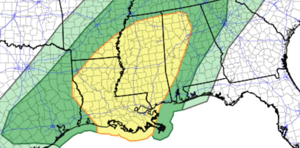
The Slight Risk in yellow and the Marginal Risk in green. Recall a Slight Risk is a “2” on the 1-to-5 sclae where a “5” is the highest risk for the most significant severe weather. The Marginal Risk is a “1” on the same scale.
I have a feeling tomorrow the Slight Risk may get trimmed southward a bit and we may see an Enhanced Risk placed across parts of Louisiana and Mississippi. The Enhanced Risk is a “3” on the same mentioned scale.
The SPC notes as warm, moist air flows northward into a developing area of low pressure it will push dewpoints into the upper 60s to near 70 will provide enough instability to support stronger storms.
Wind shear will be quite strong, and low-level wind profiles are projected to improve through the evening. This combination may allow for semi-discrete supercells and small clusters to develop. Any storm that becomes organized could produce damaging wind gusts, and a couple of tornadoes will be possible.
If the low-level jet strengthens beyond current expectations, a corridor of higher severe potential may set up from Louisiana into southern and central Mississippi.
That risk for more potent severe weather, I think, is a bit more tied to the coast. At least for our area. Since that will be where all the warmer air will be coming from. And I think that means it leaves a large portion of the area under a “conditional” risk for more potent severe weather.
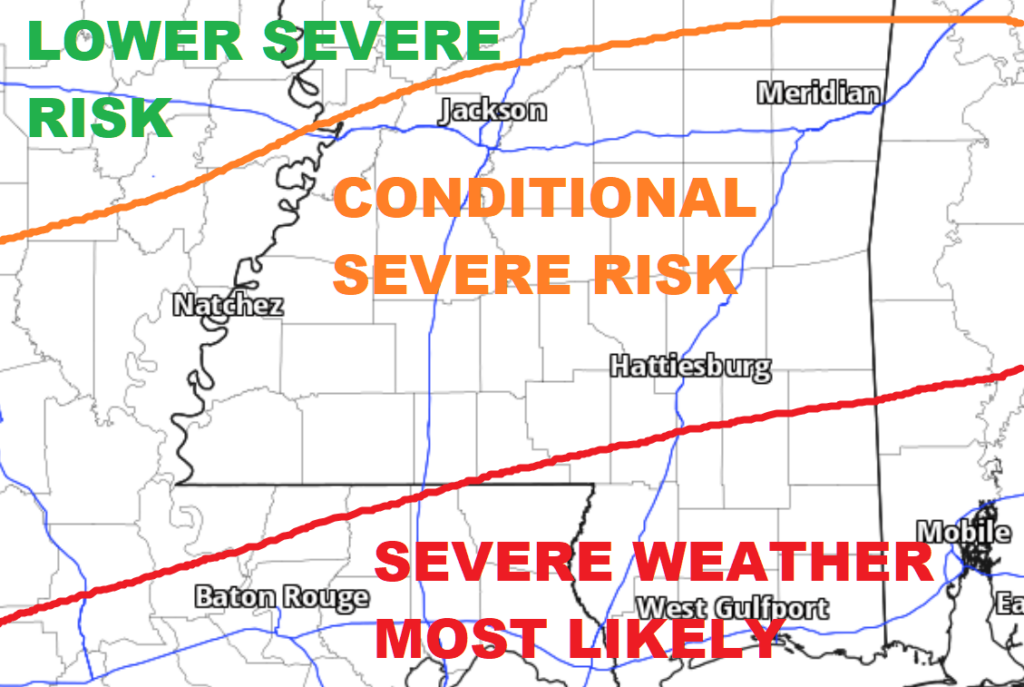
The “Conditional” severe risk covers most of the area, sadly. And comes with a handful of asterisks and contextualizing needed.
FORECAST CONTEXT
I want to breakdown the risk for storms into three different areas to note.
LOTTA WATTA
The atmosphere will be very, very moist. You probably noticed how humid it was today. That will be the case again Friday and Saturday.
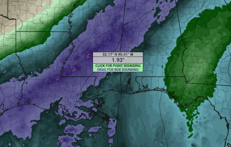
The map above shows Precipitable Water values in the 1.75+ range. And that means these storms will be proficient rain producers. Even if you don’t get “Severe” weather, any storm that plows through your neck of the woods will likely drop bucket-fulls of water.
This should limit the hail risk for tomorow for a lot of folks. So that is good. Hail doesn’t like to form when it is super moist.
But the flip side is that flooding will be much easier to come by tomorrow. While we are in drought, the ground is so dry that it may not soak up the water as quickly as it normally would. So we may see excess runoff – especially as the rain starts. That means it may not take as much rainfall to see flashy-like flooding.
The local NWS offices have highlighted parts of the area with a flooding risk. The Weather Prediction Center has also highlighted our area with the potential for flooding tomorrow and Saturday.
That means if you come across water on the road and you don’t know how deep it is nor can you tell if the road is even still there… find another way around.
MUCH SPINNY
The wind shear tomorrow will be plentiful. Not that there will be, like, 100kts of it. But rather we will see a wide area underneath a favorable wind shear bubble, so to speak. So if any updraft can get rooted, it will have a long way to go before it moves into a less-favorable wind shear area
While the Updraft Helicity Streaks aren’t very robust tomorrow, I’m concerned the models aren’t handling the potential strength of the updrafts themselves and are underestimating the number of individual streaks.
Recall that the placement of the streaks is less important than the density of the streaks on the map. So, if a streak is moving over your house, it doesn’t mean “as much” as if there are a dozen lines near your house.
QUESTIONABLE CAPE
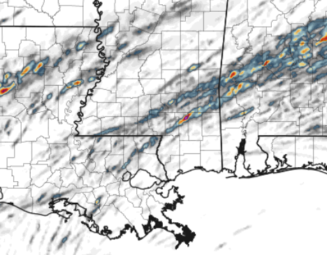
Going along with the updraft problem, I’m concerned the instability (CAPE) tomorrow isn’t being predicted well by the model guidance. And specifically the line between the “haves” and “have notes”.
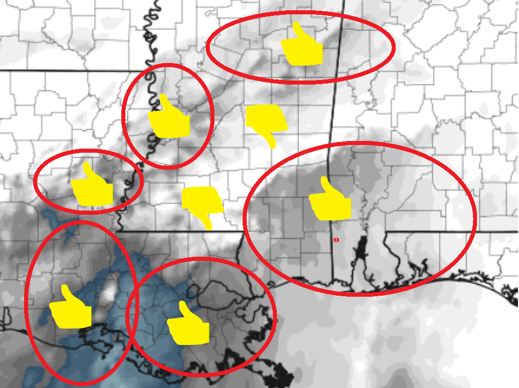
For example, on the model I am showing here, the shaded in areas in the red circles are points with “good instability for making tornadoes” while the other areas (not circles, for instance) are not areas with enough instability to make tornadoes.
But, like, that would indicate a giant cold pool in the middle of the area (likely due to a lot of rain) meaning the severe risk north of the cold pool is effectively zero. The risk in the cold pool is zero. And the risk south of the cold pool is robust.
The difficult part is that models stink at predicting the exact placement of a developing cold pool during convective severe storms. So, if that cold pool is farther north, it means more of the area is in a risk for severe weather and if it is further south it means less of the area is in the boat for severe weather.
SO WHAT DOES ALL OF THIS MEAN?!
I say all of this to add context to a bit of a complicated forecast. What I don’t want is for some folks to be super concerned and stay up all night worrying because there is a chance (a reasonable one) that they don’t even see severe weather tomorrow.
But I also don’t want folks to say, “phooey on this” thinking we won’t see any storms or severe weather because there is a reasonable chance that we see a handful of potent storms and a few tornadoes.
All of the riff-raff I just walked through is a long way of saying that a big portion of our area will be on the tightrope between “a limited risk for a few strong storms with a mess of rain and lightning only” and “multiple sever storms with the potential for a few tornadoes”.
And I admit, reading this, many people may say, “well duh, Nick, we are always between storms and no storms. Either a tornado happens or it doesn’t, dummy.”
But while the outcome may be binary – either it happens or it doesn’t – the prediction of that event is, sadly, very continuous and nebulous on days like tomorrow.
TIMELINE
The timeline looks like this:
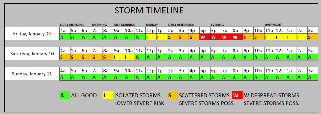
I think the earliest the storms start is around noon (perhaps an hour or two earlier in our western areas) and we see the most storms between 5p and 9p. Then things ease off a bit in density, but not intensity, for a few hours and then pick back up again in the re-dawn hours of Saturday morning.
THE BOTTOM LINE
Storms are possible tomorrow and into Saturda ymorning. Some of these may be severe. Som storms may pack soe very heavy rain, frequent lightning, wind gusts up to 65mph, small hail and a tornado. I thinkt he risk for EF-0 to EF-2 tornadoes tomorrow exists, but seeing anything stronger than a low-end EF-3 tornado looks less likely unless we see something change from the model guidance.
The timeline shown above suggests a longer, drawn out event. But that doesn’t mean it will be raining the hwole time. You may see breaks here and there between storms.


