I want to start off by saying this post is less about me saying “here is the forecast” and more about me saying, “the data right now looks similar to…”
A quick reminder before I get too far here, when we look at “analogs” we are trying to find times in the past when the atmosphere looked similar to what the models are currently showing. The analogs are pulled from ensemble guidance – not the deterministic stuff. So the maps you see floating around social media aren’t included.
I spent some time today contemplating making this post as we are still quite a few days out, but after digging through some of the extra data this evening, I decided this was probably worth the note.
THE ANALOGS
Below are the analog maps for temperature and precip for January 23 – January 27. You can see the dates on these maps, too. Feb 2021, Feb 2025 are the top two. The third was, thankfully, a bit more of a Nothing Burger for us.
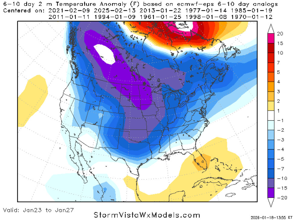
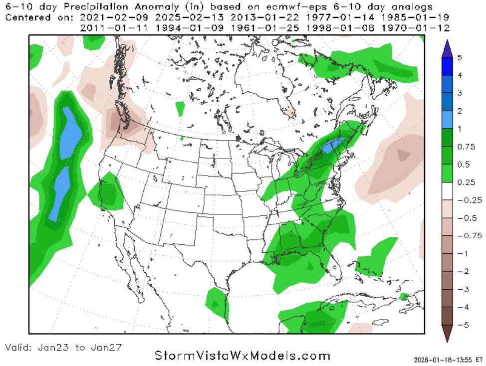
The top analog, though, is worth noting. Mainly because it was a pretty big ice storm event for the area. Not so much for our southern counties (say, south of HWY 98) but for our central and northern counties (particularly closer to I-20).
At the time, I uploaded the forecasts from a few days out because it was an event that I think we did a reasonably good job at forecasting the overall setup… but the original forecast data was woefully too warm. And I knew I would want to have the video later should be run into a similar situation.
And, well, here we are.
We have another calving of Polar Vortex action. We have another push of cold air from Canada. We have another potential set of systems set to move through while all of this is happening.
That event wasn’t just a singular event, either. It was a multi-day event. Where we had a shot of cold move through with three rounds of precipitation.
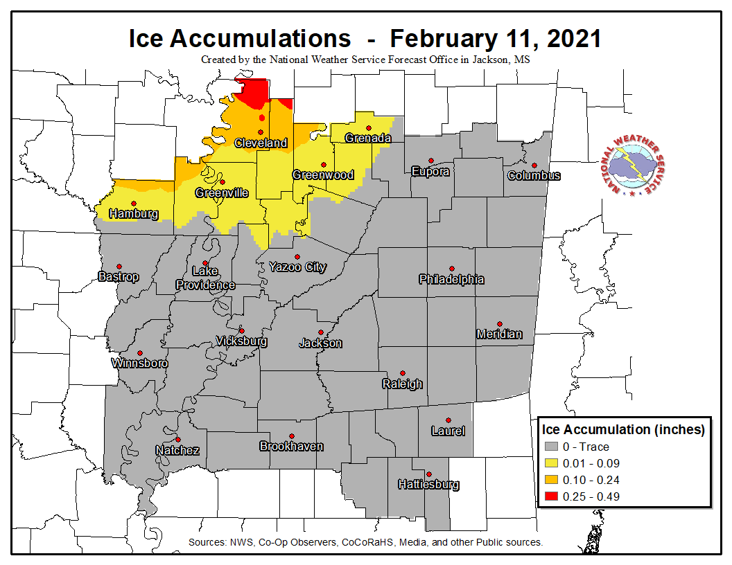
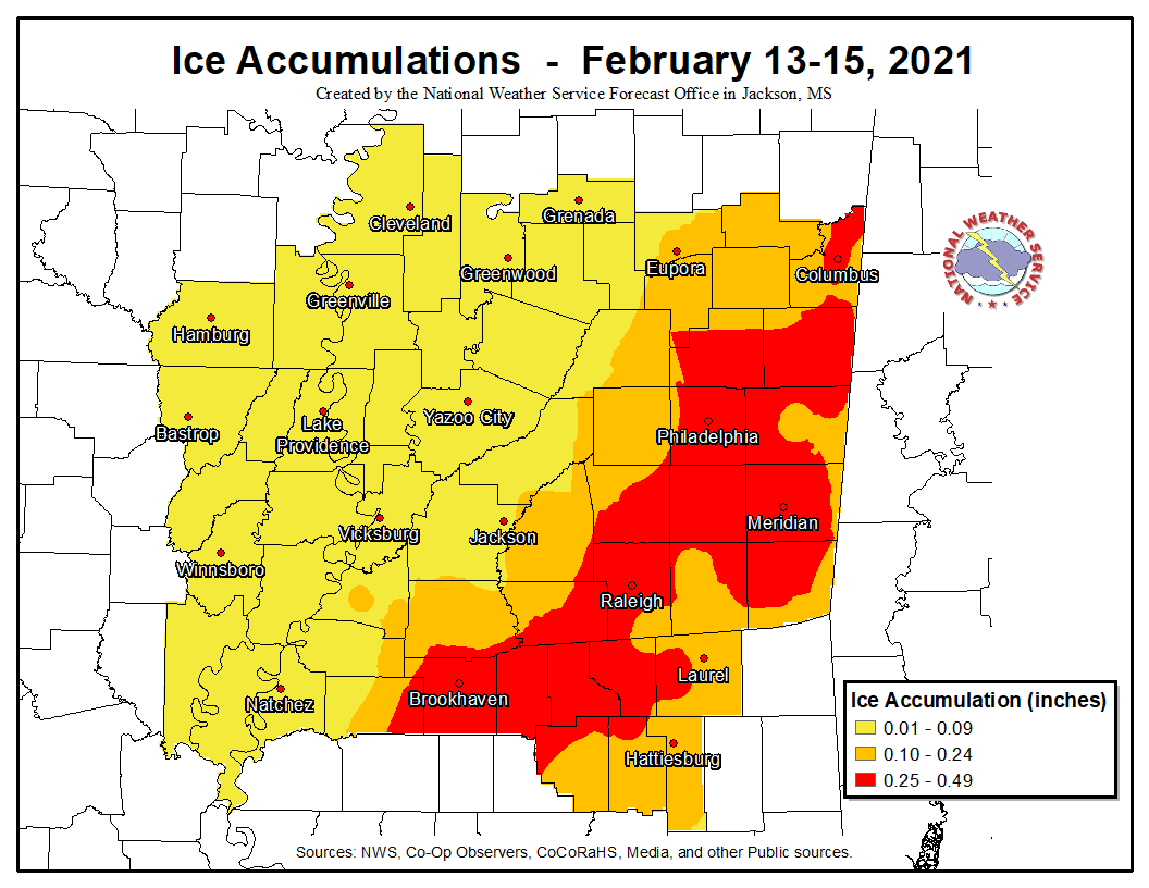
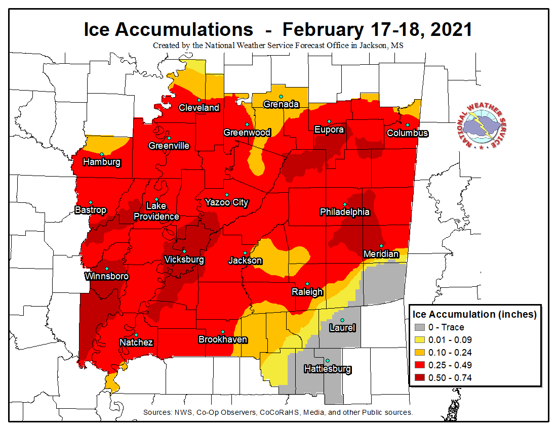
This led to a pretty stout glazing of parts of the region with some significant ice accumulations across multiple days. And a very, very sharp cut-off between ice accumulation (and a lot of it) and nothing. Look at the third map and the gradient between Clarke and Lauderdale counties. The northwest side of MEridian shows up to 0.74″ of ice but then you go south of town a few miles and you got to nothing but rain.
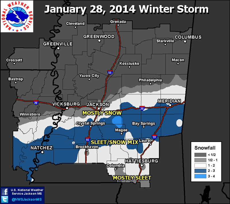
Oh, and another analog that I didn’t show is January 27th, 2014. Int he window around that day we had an ice storm for our area, too. With another sharp cutoff.
Not good.
The “second” top analog rom the maps above was this day: Triple-shot of severe weather
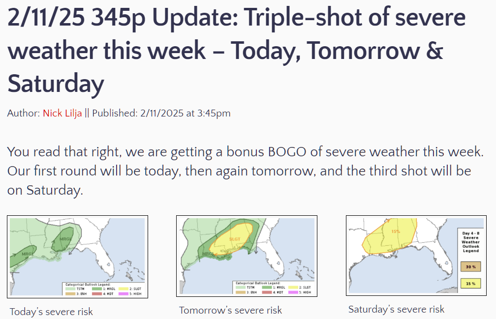
That’s right, a stretch of, basically, three days of severe weather within a 5 day stretch. Mainly because we were on the warm side of the stationary front and successive systems move through with warm air in place and cooler air intrusions behind them.


This setup ended up producing about five tornadoes for our area as well as numerous wind reports and some hail.
WHAT DOES THIS MEAN FOR YOU
I mentioned on facebook today that we were enter a very active pattern during the next week. Nothing has changed there. It just may feature some added flavor.
I will say I do feel a bit like Ron White. He has a line about hurricanes, “it isn’t THAT the wind is blowin’… it is WHAT the wind is blowin'”
In our case, it isn’t THAT the weather will be active, it is HOW the weather will be active. Because we could be facing the risk for ice or snow. Or just cold rain. Or tornadoes.
All that said, the one thing I can tell you: It won’t be 70F and sunny this week.
But jokes aside, the take home here: Find a trusted source of local weather information for the coming days. Seriously. Someone local. For some of you that means TV. For others maybe it is someone online. Just find someone who knows your area. Maybe it is Dave Roberts at WLBT or Patrick Bigbie and WDAM. Maybe it is Spinks Megginson at Redzone Weather. Or maybe it is Nick Mickulas at CenLA Weather. Maybe it is even me!
Just find someone local.
Because, given the data so far, the difference between “getting rain” and “getting ice” and “getting snow” and “getting tornadoes” may end up being a sharper cut-off than a national or regional outlet can provide.


We appreciate you, Nick!