We are once again looking at another week of morning showers followed by scattered thunderstorms in the afternoons. Severe storms are not expected, but tropical rain showers with frequent thunder, dew points pushing 80 degrees, and temps in the low-to-mid 90s will not promote outdoor activity this week. Let’s dive into the detailed forecast:
Today’s Overall Setup
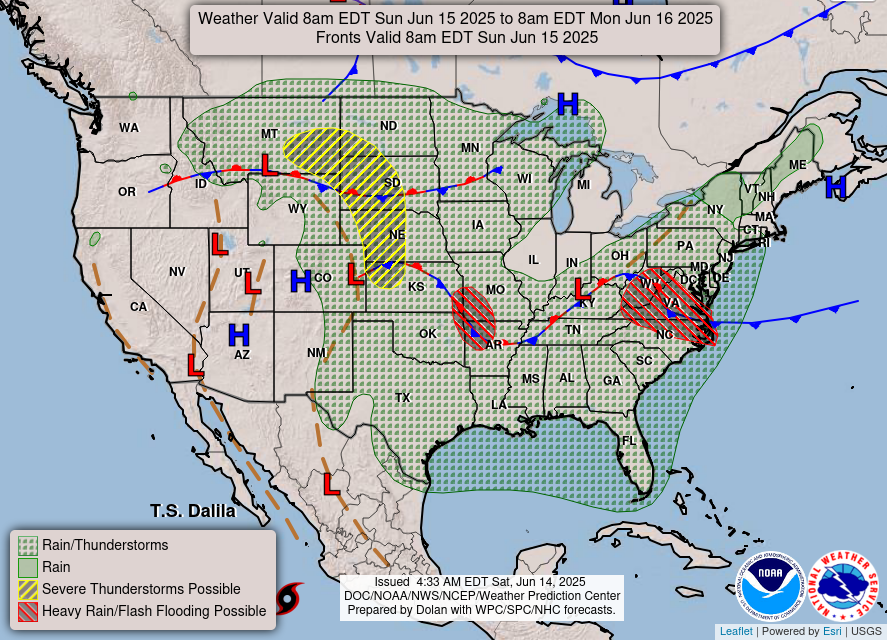
Today’s overall setup for the CONUS is a large scale area of showers and thunderstorms for most of the country, primarily east of the Rockies. The stationary fronts in the northern plains and the midwest are responsible for the unsettled weather, and areas in red could see heavy rain and a flash flood threat over the next 24 hours. Severe weather is possible in the northern Plains from eastern Montana into North and South Dakota, Nebraska, and northwest Kansas. The SPC has a Slight (level 2/5) risk of severe weather for that region. Large hail, tornadoes, and severe winds are possible in the severe risk region, with that area shifting east tomorrow into Minnesota and Iowa. We will be keeping a close eye on that area today and tomorrow.

Moving up to the middle layer of the troposphere, 500 mb, we can see that the areas that are receiving rain and severe weather are under an area of low pressure with enhanced winds. These lows will be pushed to the east southeast over the coming day – forced by the building high pressure to the west. Our area, southern MS/AL/LA, will not see any severe threat in the coming days. We simply do not have enough upper level support for severe development.
Today’s Local Forecast
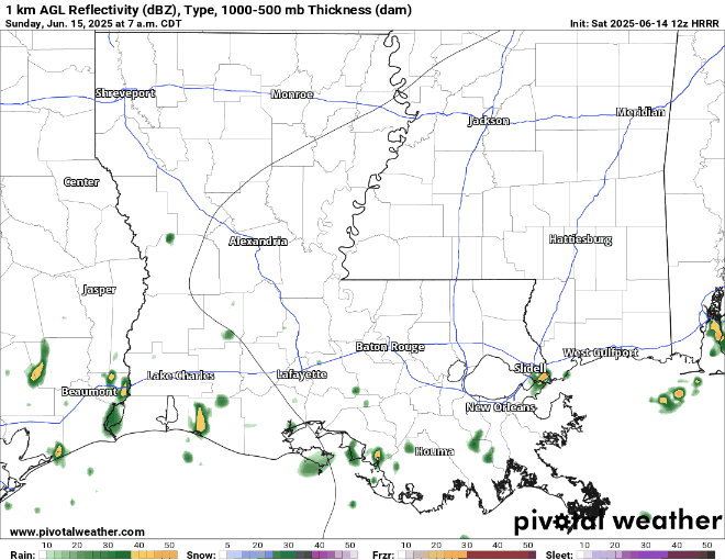
We start today off with cloudy skies and a very moist atmosphere. Southwestern Louisiana is the first to experience the showers and thunderstorms at around 9-10 am. It moves northeastward into the afternoon, filling into Mississippi at around noon and will last until around 10-11 pm. These showers and thunderstorms will be scattered, with some areas seeing more intense rain than others. It will be cloudy through the afternoon and evening when not raining, so it will be an overall soggy day – like yesterday.
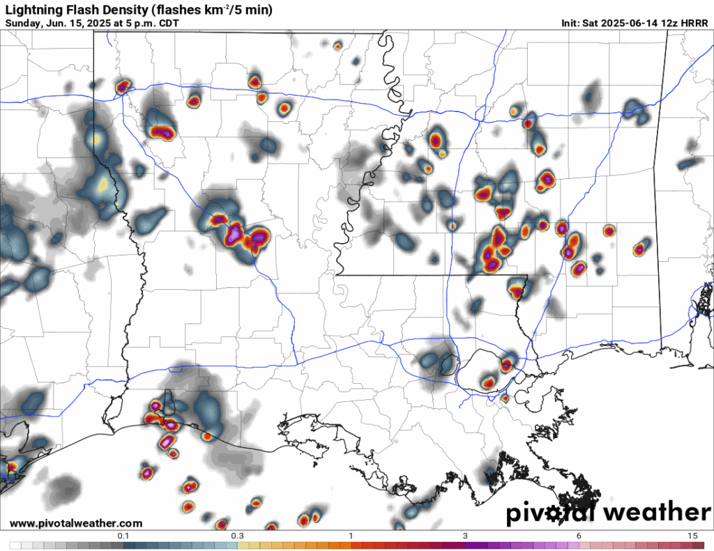
As you can see from the above image, these cells will contain frequent lightning. Be sure to stay indoors when these storms push through. The best chance for the most frequent lightning will be at around 5 pm, once all of the built up heat energy from the day charges up the storms.

Here’s an hourly look at the forecast for today for the region.
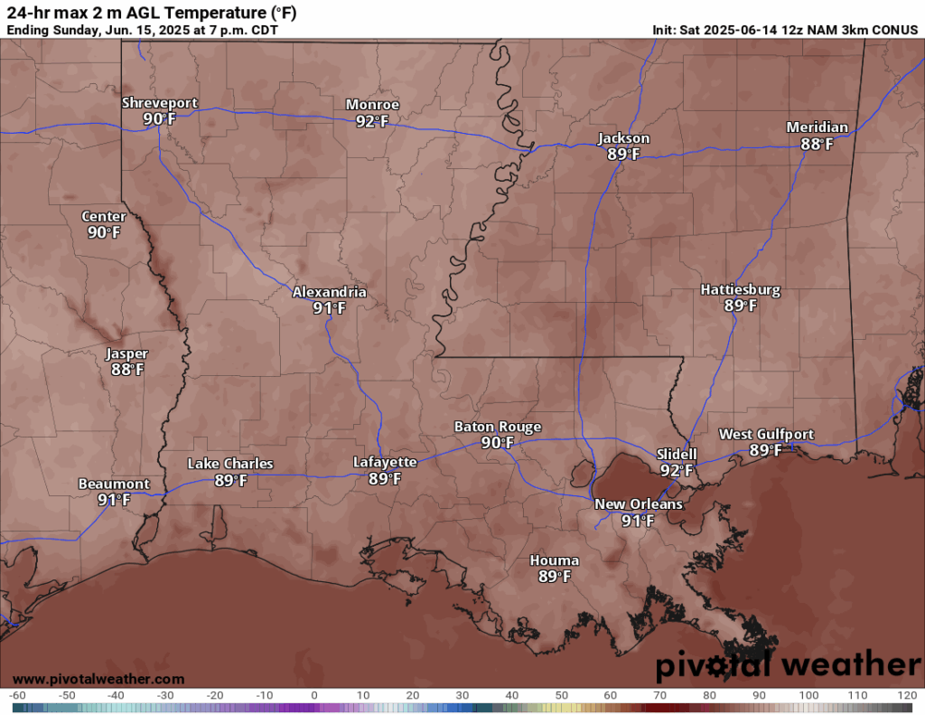
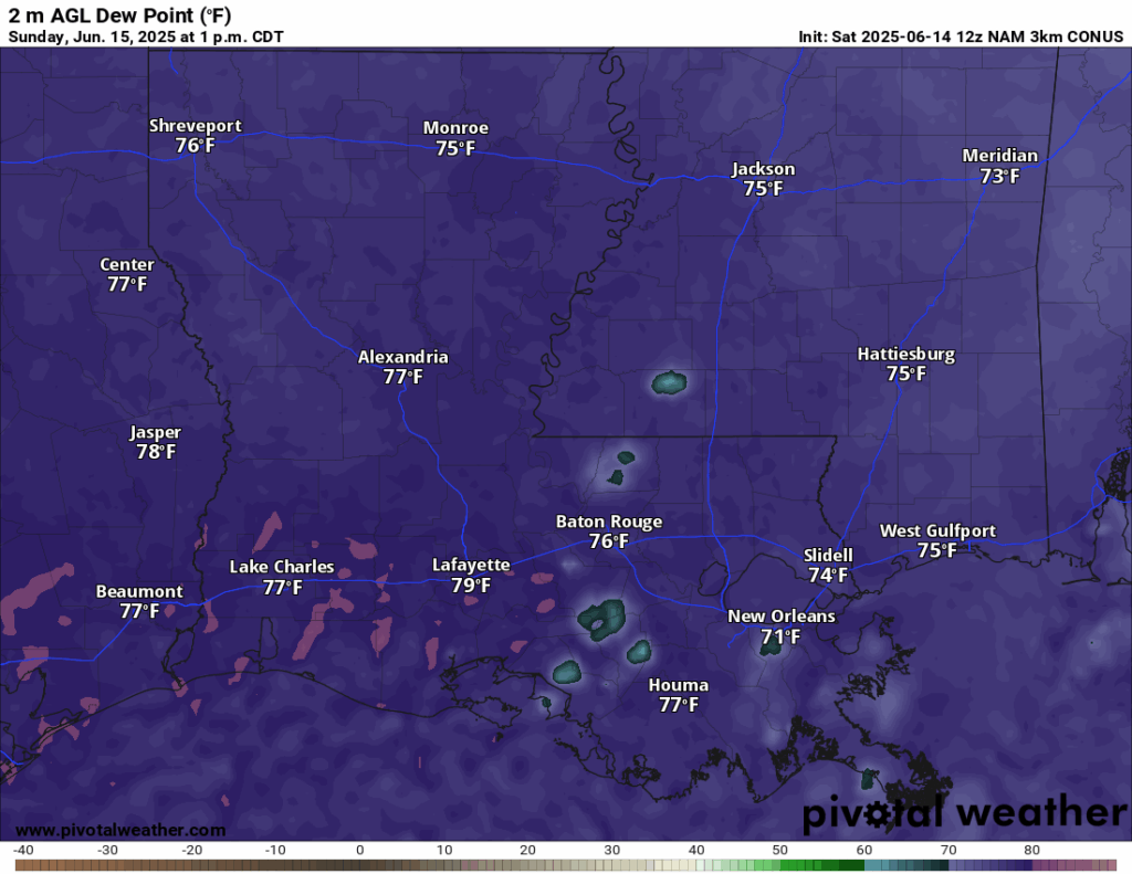
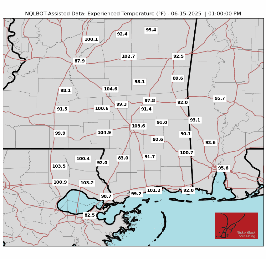
High temperatures today will be sitting around 88-89 degrees in middle to lower Mississippi. Westward into Louisiana will see mainly 90-92 degrees for your high. Today, like yesterday, will be extremely humid. Dew points are pushing 80 degrees. I consider 70 degree dew points very uncomfortable, so 80 degree dew points are out of the spec of my imagination – just unbearable! With experienced temperatures into the 100s, dew points in the high 70s/low 80s and the showers and thunderstorms coming through, I would recommend taking your plans inside today, if possible. If you must be outside, keep an eye out on the NickelBlock radar, turn on NickelBlock’s instant lightning alerts, and drink plenty of water.
This Week’s Forecast
Here’s a look at the forecasted temperatures for this week up until Friday. Each day we will have highs in the very high 80s and low-to-mid 90s.
On Monday, showers will occur in the morning hours, with a heavy band of rain coming through at around 1 pm and sticking around until around 7 pm. A similiar pattern exists for Tuesday, Wednesday, and Thursday. By Friday, there should be less intense showers and thunderstorms, with only isolated storms in the afternoon.
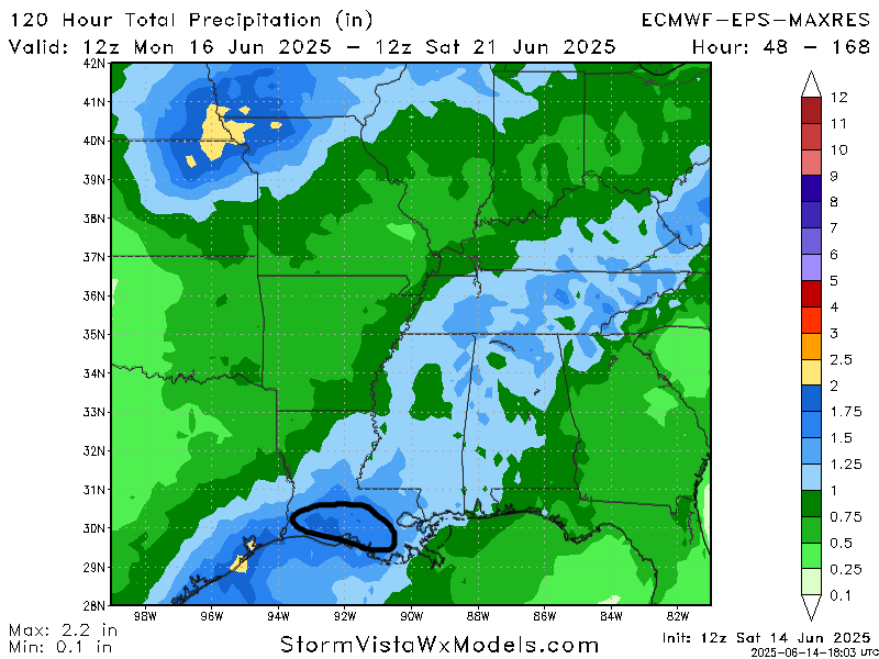
Looking at the total rainfall amounts from the European model through Friday night, most of the rain will accumulate in southwestern and southern Louisiana, with up to 2 inches of rain. Lower Mississippi and Alabama will see less rain, with around an inch to an inch and a half for the week. Those who are right under the heavy bands consistently could see isolated 2 inch plus totals.
Extended Local Outlook

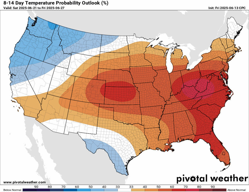
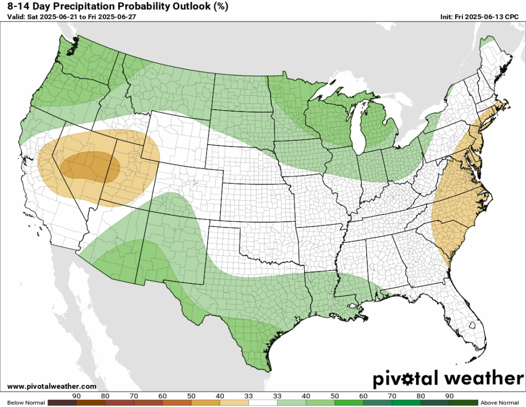
Looking ahead at the next 8-14 days, the Climate Prediction Center (CPC) is going for a very likely chance that temperatures in the central/east region of the country will be above average. Ridging looks to be very intense in the next week or two, which brings warmer temperatures under high pressure. This is also why the same areas will be see below to near average precipitation during this time as well. Here in our area, we will see those warmer than average temperatures, with a small chance of increased precipitation. Those daily afternoon thunderstorms may not see an end for a little while!
Latest Tropical Update
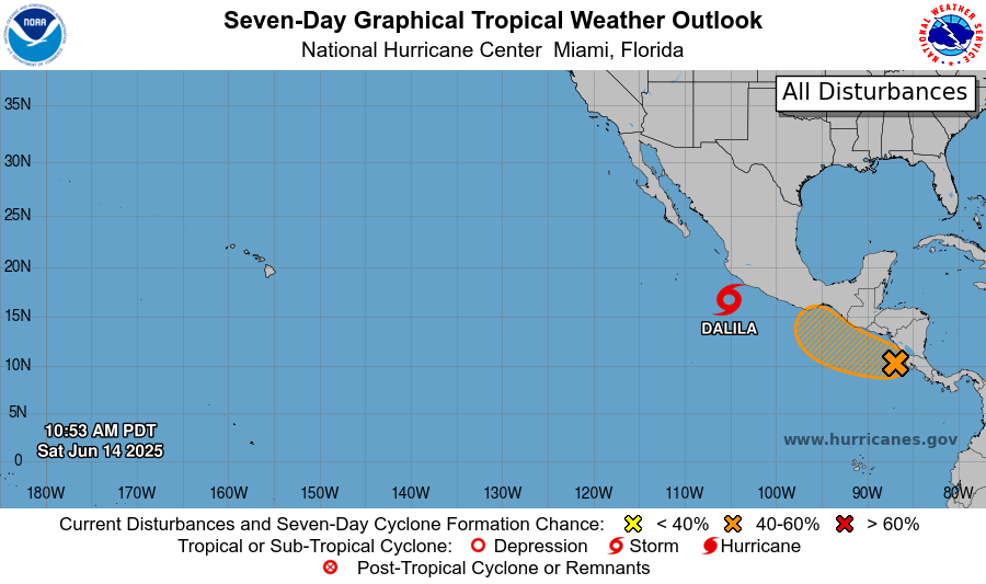
Currently in the tropics, we have newly named Tropical Storm Dalila just off the western Mexican coast. Tropical storm forced winds and rainfall are expected for the coastal areas there. Behind Dalila, there is a tropical disturbance that has a 20 percent chance of development in the next 48 hours, and now an increased 50 percent chance in the next 7 days.
Want the latest details on these systems? Check out our daily tropical updates for more in-depth information on the tropics!
REGIONAL DAY TO DAY FORECAST
Today: Showers in the morning, afternoon thunderstorms likely. Highs in the low 90s. Calm winds becoming south southwest around 5 mph in the afternoon. Chance of rain 80 percent.
Tonight: Partly cloudy. Lows in the low 70s. Calm winds.
Monday: Showers in the morning, thunderstorms in the afternoon. Highs in the low 90s. Calm winds becoming southwest around 5 mph in the afternoon. Chance of rain 80 percent.
Monday Night: Partly cloudy. Lows in the mid 70s. South winds around 5 mph becoming calm.
Tuesday: Showers in the morning, thunderstorms in the afternoon. Highs in the low 90s. Calm winds becoming south around 5 mph in the afternoon. Chance of rain 80 percent.
Tuesday Night: Partly cloudy. Lows in the mid 70s. South winds around 5 mph becoming calm.
Wednesday: Mostly sunny, then showers and thunderstorms in the afternoon. Highs in the low 90s. Calm winds becoming south around 5-10 mph. Chance of rain 70 percent.
Wednesday Night: Partly cloudy. Lows in the mid 70s. Chance of rain 30 percent.
Thursday: Showers and thunderstorms likely. Highs in the mid 90s. Chance of rain 70 percent.
Thursday Night: Mostly cloudy with showers and thunderstorms possible. Lows in the mid 70s. Chance of rain 20 percent.
Friday: Isolated showers and thunderstorms, then clear. Highs in the mid 90s. Chance of rain 50 percent.
Friday Night: Partly cloudy. Lows in the mid 70s. Calm winds.
Saturday: Partly cloudy with isolated afternoon thunderstorms. Highs in the mid 90s. Chance of rain 30 percent.
Saturday Night: Partly cloudy, then clear. Lows in the mid 70s. Calm winds


