This week will feature a typical early summer Gulf Coast pattern: warm, humid days with daily chances of thunderstorms, especially in the afternoon and evening. A weak upper-level disturbance and ample Gulf moisture will enhance rain chances midweek. By the weekend, slightly drier air may reduce storm coverage, but isolated storms remain possible.
A weak upper-level disturbance
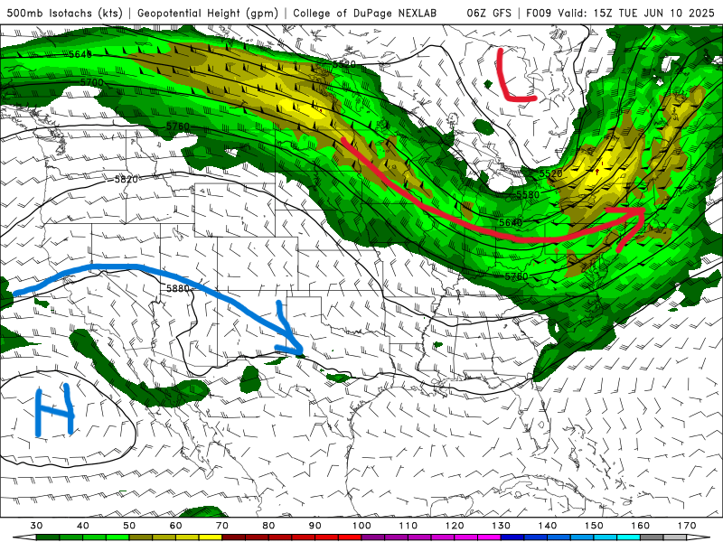
A weak upper-level disturbance a small dip in the jet stream high above the Gulf Coast will move through the region midweek. This feature causes air to rise more easily, which helps thunderstorms form and grow stronger. Combined with plenty of warm, moist air from the Gulf, this disturbance will lead to more widespread and intense storms from Wednesday through Friday.
Warm, humid days
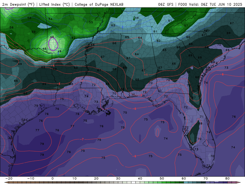
This region is influenced by subtropical air masses from the Gulf of Mexico. These air masses are warm and moisture-laden, especially in early summer. Daytime highs in the mid to upper 80s °F, with dew points in the 70s, making it feel hotter and more oppressive. This high humidity also fuels thunderstorm development. The southerly winds bring in moisture from the Gulf of America. This moisture increases precipitable water values, meaning the atmosphere can support heavy rainfall and frequent thunderstorms.
Daily afternoon showers and thunderstorms

The sun heats the surface during the day, causing surface air to rise (convection). When this warm, moist air rises and cools, it condenses into clouds and eventually thunderstorms. Storms often persist into the evening as the atmosphere remains unstable and moisture-rich, even after sunset.
High pressure builds in early next week

As the midweek disturbance moves out, a ridge of high pressure or a shift in wind direction brings in drier, more stable air. This suppresses storm development, leading to fewer, more isolated, and weaker thunderstorms over the weekend. This high pressure system will continue to more east early next week bringing overall drier conditions to the Southeast.
Regional Day-to-Day Forecast
Tonight – Partly cloudy and warm. Humid conditions continue. The low will be 76°F, with light southerly winds.
Wednesday – Partly sunny with scattered afternoon thunderstorms. The high will be 86°F with a 60% chance of rain. Winds SSW at 5–10 mph.
Wednesday Night – Partly cloudy with isolated storms possible. The low will be 78°F.
Thursday – Partly cloudy with a few isolated thunderstorms, mainly in the afternoon. The high will be 87°F with a 30% chance of rain. Winds SSE at 10–15 mph.
Thursday Night – Mostly clear with patchy clouds. The low will be 79°F.
Friday – Scattered thunderstorms, especially in the morning. The high will be 87°F with a 30% chance of rain. Winds SSE at 10–15 mph.
Friday Night – Mostly cloudy skies. The low will be 80°F.
Saturday – Mostly cloudy early, then partly cloudy in the afternoon. The high will be 88°F with a 20% chance of rain. Winds S at 10–15 mph.
Saturday Night – Partly to mostly cloudy. The low will be 79°F.
Sunday – Partly cloudy skies. A few afternoon storms possible. The high will be 89°F with a 20% chance of rain. Winds SSW at 5–10 mph.
Sunday Night – A few clouds from time to time. The low will be 78°F.
Monday – Variable clouds with thunderstorms, especially in the afternoon. The high will be 89°F with a 40% chance of rain. Winds SW at 5–10 mph.
Monday Night – Partly cloudy in the evening followed by scattered thunderstorms after midnight. The low will be 79°F with a 40% chance of rain.


