Happy Tuesday and Merry Christmas Eve Eve (for those who love Friends). Surely, you all are tired of the warm, dry pattern we have been stuck in, but unfortunately, it will stick around for a little while longer.
From now until the day after Christmas, you can expect high temperatures ranging from the upper 60s to mid-70s, with low temperatures ranging from the upper 50s to mid-60s. It will be dry and unseasonably warm over the next 72 hours, thanks to the persistent high-pressure dome still dominating the area.
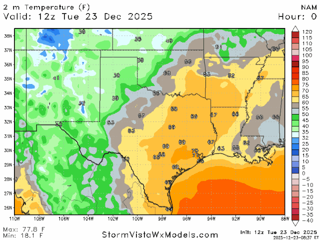
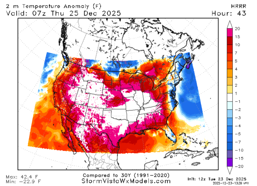
The temperature GIF above shows our temperatures from now until December 26th. We can see that we are staying well above the average temperatures for this time of year. There is not a lot of variability in the high and low temperatures during this time frame due to the strong dome of high pressure.
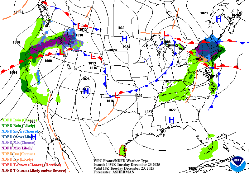
Looking at the surface map above, we can see the high-pressure dome sitting east of our region. Blame the high pressure for the warm, dry, and generally moderate weather conditions.
Sadly, we will not be having a white Christmas… it will be more like 70 degrees with a mix of sun and scattered clouds.
After Christmas into New Year’s Eve:
This pesky high pressure will stick around until the end of the week, keeping us warm, but it will begin to migrate away. For the rest of the week, expect temperatures to be in the mid-to-upper 70s, with overnight lows in the mid-60s. By Sunday, the 28th, the cool-down we have all been waiting for arrives!

The cooler temperatures will begin Sunday night and can be attributed to the low-pressure system centered over the Great Lakes. This surface analysis map allows you to see the low-pressure system with the cold front attached and illustrates just how far it reaches.
These cool temperatures are expected by Sunday night, and it is quite the cool down! By next Monday, the high temperatures are expected to be in the upper-40s to low-50s, and low temperatures in the mid-30s. Some locations could see freezing temperatures overnight and wake up with a dusting of frost on the 30th.
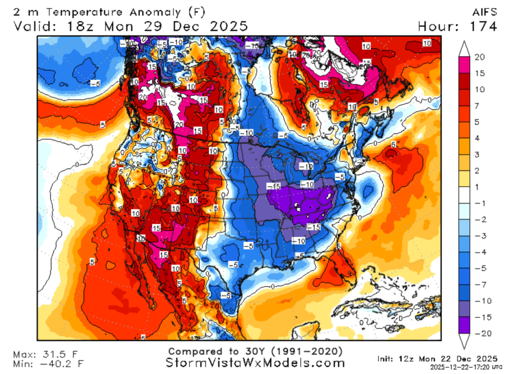
This temperature anomaly map shows we will be around 5 degrees below the average temperature for this time of year. Expect these cooler conditions to last through the 30th of December.
Crazy how fast the weather changes!
Cold fronts bring more than just cooler temperatures; they also bring precipitation. While the models agree about the timing of the cold front and the temperature drop, they disagree about the amount and coverage of precipitation.
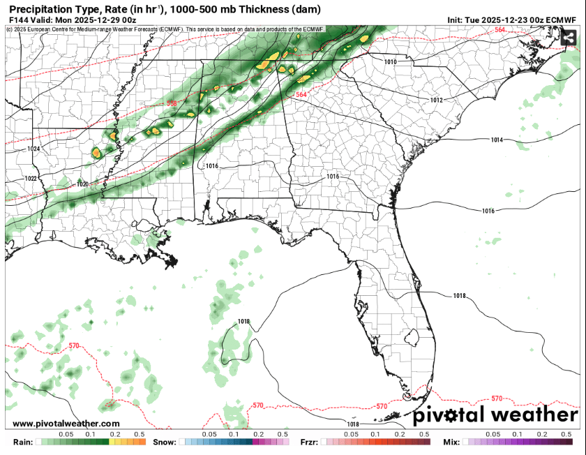
On the left is the GFS model, and on the right is the ECMWF model. The ECMWF model seems to be overestimating the strength of the precipitation, while the GFS model shows a more moderate scenario.
We will continue to watch the models to see how they align, but for now, be prepared for some scattered showers Sunday night along with much cool temperatures.
New Year’s Eve and beyond:
The cold front attached to the low-pressure system will persist until December 30th, bringing cooler-than-average temperatures and precipitation to the region. Once the front has passed, we can expect temperatures to increase slightly, but we will not get as warm as we were before Christmas.
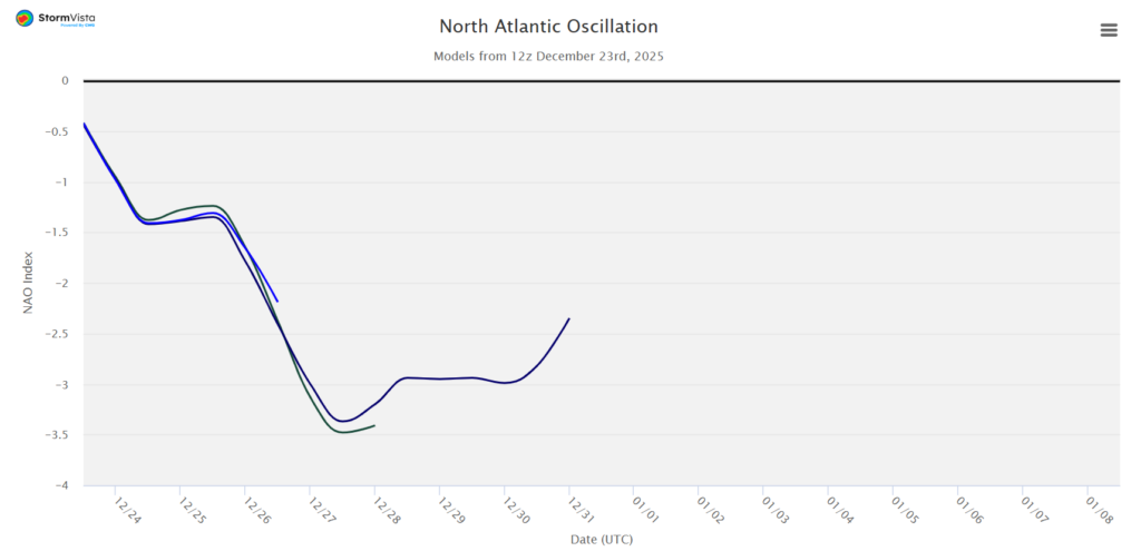
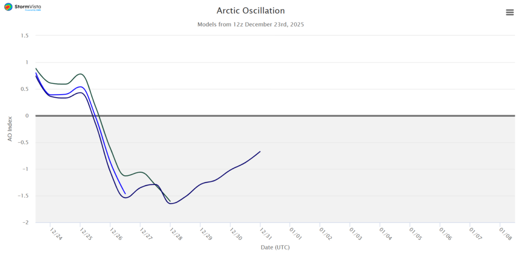
These two graphs represent two teleconnections, the NAO and the AO. Teleconnections are a great way to identify long-term trends in temperature as they are based on climatic averages. Both the NAO and AO show the differences in pressure between two locations and how those differences relate to temperature changes.
Looking at both graphs, we can see the dramatic dip around December 26th; this is the cold front we are expecting on the 28th. When the NAO or AO goes negative, the temperatures decrease, and this is exactly what we are seeing.
Then the graphs increase slightly, but they do not get nearly as high as they were before Christmas. This means that our temperatures in the New Year will not be as high as before Christmas, but also not as low as they are during the front.
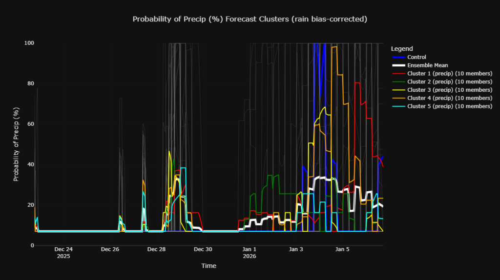
Looking at the precipitation ensemble for New Year’s and beyond, we can see an increase in the precipitation during our front on the 28th, and then again right after the New Year. This increase in precipitation chances is likely due to our upper atmosphere moving out of the dominant ridging pattern.
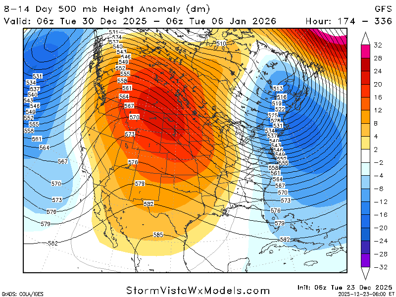
Looking at the 500mb height anomaly map above, our area is in more of an in-between stage. We are no longer being dominated by a ridging atmosphere that causes warm and dry conditions, but the stronger troughing remains to the East. We will see increased chances of precipitation and more variable temperatures due to the upper atmospheric set-up.
So, for the New Year, expect cooler temperatures and more chances for some much-needed rain!
Beyond the first week of the year:
If we keep looking out, past January 5th at our temperatures and precipitation, what do we see?
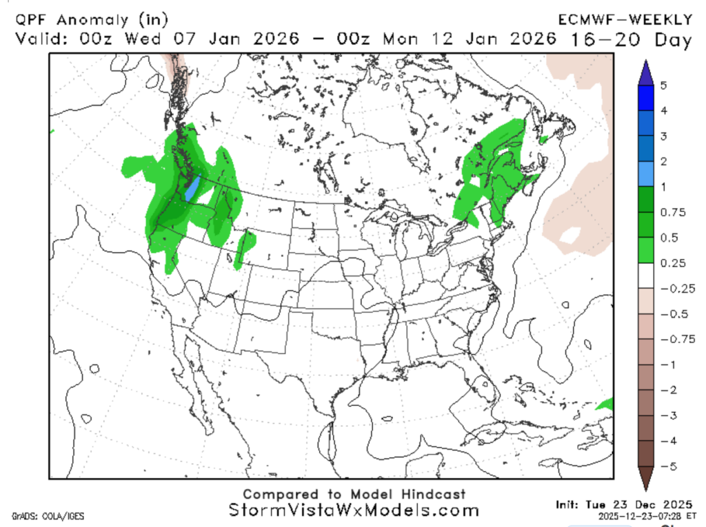
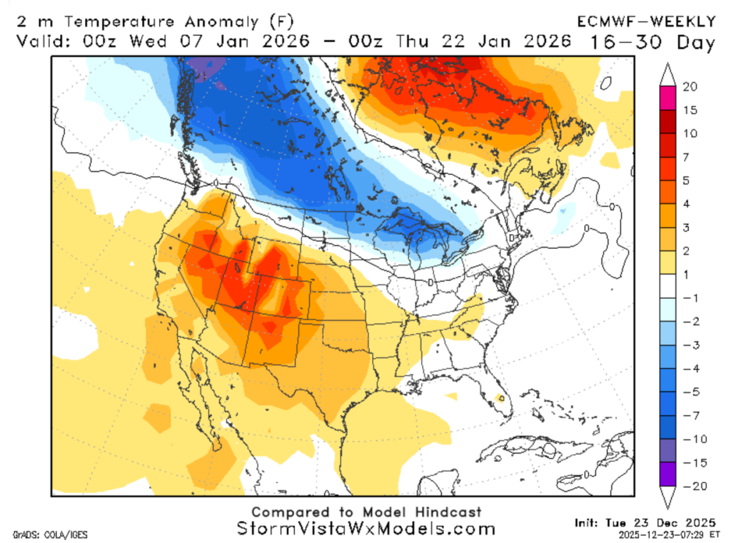
On the left, we have the QPF (quantitative precipitation forecast) anomaly, and on the right, the temperature anomaly.
For the QPF, it is how close we are to the average amount of precipitation for the time of year, and we are sitting at 0.25 inches. This means we will get 0.25 inches more than the 30-year climatic average for precipitation. We have been pretty dry, so this is moving us in the right direction!
For the temperature anomaly, it is how close our temperatures are to the 30-year climatic average. We are at about 1-2 degrees above the average, which is pretty good considering that around Christmas, we were about 10-15 degrees above the average.

These maps show the comparison of Christmas Day temperature anomaly to the second week of January. It looks like the New Year will start with some cooler temperatures and moderate precipitation.


