Hey everyone! We have another two days of severe weather risk for our area, with a Marginal (1/5) risk on the threat scale for both today and Friday. While this is a lower threat, there still is the possibility of some strong to severe thunderstorms that could present heavy rain, damaging winds, and some hail. The tornado threat is minimal, but as we all know, any colliding outflow boundaries can spin up a quick tornado. Let’s take a look at the setup.
Overall Setup
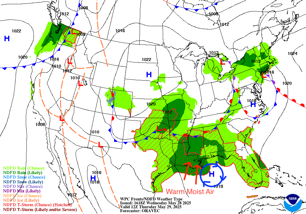
Taking a look at our overall synoptic pattern for today, that stationary front is still in our area, which is destabilizing the atmosphere once again to bring us a soggy, and potentially severe weather day. The high pressure that you can see in the Gulf is funneling in warm/moist air from the tropics. The stationary front in conjunction with the large amount of moisture is responsible for the unsettled weather today and tomorrow. The Weather Prediction Center (WPC) has a Marginal (5%) risk of Excessive Rainfall for our area – all of Louisiana and the lower half of Mississippi.
Current Local Conditions

Taking a look at our current temperatures in the figure above, we can see we are warmer towards the coast approaching the 80’s and cooler the more inland you go, in the 60’s and 70’s. These inland areas will warm up quickly through the day as that southerly wind fuels that warm/moist gulf airmass. This warm/moist airmass that we are experiencing is the fuel for the storms coming through today.
Today’s Local Forecast
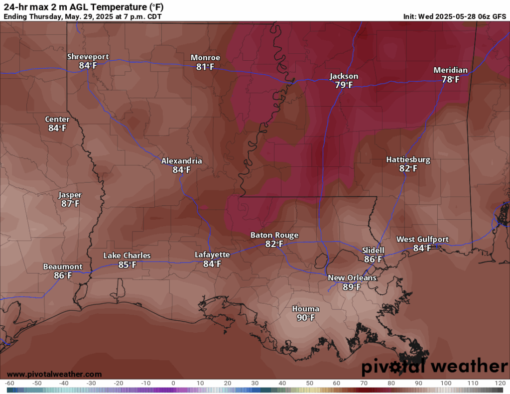
High temperatures for today will reach around 90º in the New Orleans and Houma area, with the rest of the Louisiana state in the low-to-mid 80’s. Those of you on the gulf coast of Mississippi will have a high today of around the mid 80’s, with central and northern areas of the state not breaking out of the 70’s! Definitely some nicer temperatures for that area compared to the blazing heat we have been experiencing recently!

Todays forecast is shown in the figure above, giving you an every 3 hour look of the weather you could expect.
Severe Weather Threat Today
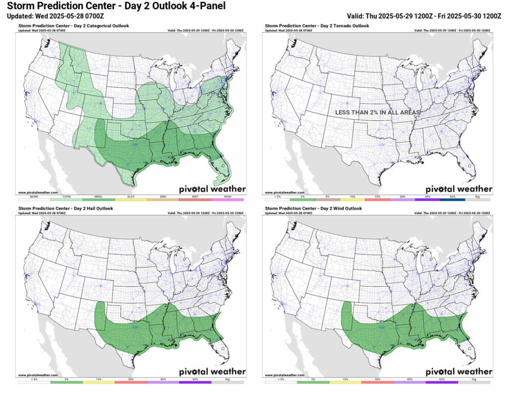
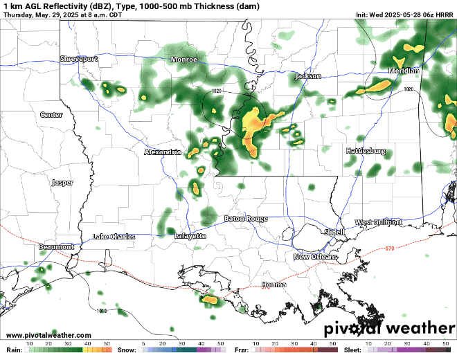
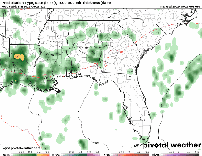
Today, you can expect those rain bands to push through northern Louisiana in the early morning – then pushing southward into Baton Rouge, New Orleans, Hattiesburg, and West Gulfport areas by the early afternoon. This line of showers could contain those severe storms mentioned earlier, so make sure you are not stuck with any outdoor plans if you are in this area from noon through the evening. These storms could potentially be supercells, based on the high-resolution HRRR guidance. As you can see in the 4-Panel categorical risk plot above, gusty winds and hail are the main threat for these storms. Remember, when thunder roars, go indoors!
Looking into the weekend
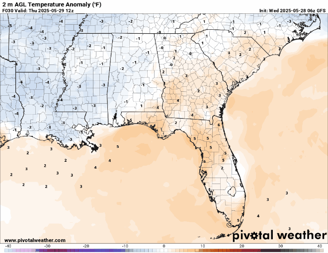
Looking at the end of the work week into the weekend, temperatures are generally trending cooler than average. Temperature anomalies are looking around 10º below the average, which will bring our high temperatures to around the low 80’s for the weekend – which I personally think is the perfect temperature!
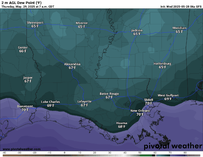
Not only will temperatures not be as hot as they have been, the humidity will also be much lower. Those 70º dew points make it almost unbearable to stay outside, so it’s great news that this weekend – Saturday & Sunday – we will have dew points only in the 50’s and 60’s! This makes going outside much more enjoyable, so soak it up while you can.
Looking ahead, in terms of rainfall and severe weather, after we get through the severe storm threat today, we have another threat of severe weather for tomorrow, Friday. Like today’s threat, we are looking at a line of storms that could bring gusty winds and some hail. The line of storms shoulld come through the area in the early afternoon hours of Friday, and will exit by the time the evening comes. We begin to clear up on Saturday, as an area of high pressure sets in. Sunday will also be a beautiful day with clear skies. With the low dew points, milder temperatures, and low chance for rainfall – it’s looking like a great weekend to go outside!
Extended Local Outlook

Here’s your 15 Day Forecast for the area. First week of June looks to be hot and humid, with real feel temperatures back into the 100’s! At least as of now, rain chances seem to be low for the first week of June, thanks to the ridging that will be taking place during that time. The pattern flip will be in full swing!
Watching The Tropics
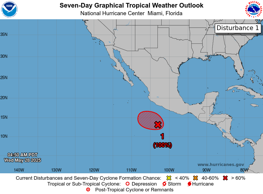
The National Hurricane Center has a 100% chance of a tropical system forming in the next 2-7 days. It is meandering in an environment that is very favorable for tropical development. Find out the latest forecast in our Tropical Updates!
REGIONAL DAY TO DAY FORECAST
Today: Afternoon thunderstorms. A few storms could be severe. Highs in the lower 80s. Southwest winds 5 mph. Chance of rain 100 percent.
Tonight: Showers and thunderstorms, clearing overnight. Lows in the upper 60s. South southwest winds 5 mph. Chance of rain 30 percent.
Friday: Morning and afternoon showers and thunderstorms, clearing by the late afternoon. Highs in the lower 80s. West northwest winds 5 to 10 mph. Chance of rain 60 percent.
Friday Night: Mostly clear. Lows in the lower 60s. Northwest winds 5 mph.
Saturday: Sunny. Highs in the lower 80s. Calm winds becoming northwest around 5 mph.
Saturday Night: Mostly clear. Lows in the lower 60s. North northwest winds around 5 mph becoming calm.
Sunday: Mostly sunny. Highs in the higher 80s. Calm winds becoming west northwest around 5 mph.
Sunday Night: Mostly clear. Lows in the mid 60s.
Monday: Sunny. Highs in the upper 80/lower 90s.
Monday Night: Mostly clear. Lows in the upper 60s.
Tuesday: Mostly sunny. A slight chance of showers and thunderstorms. Highs in the lower 90s. Chance of rain 20 percent.
Tuesday Night: Partly cloudy. Lows in the lower 70s. Calm winds.
Wednesday: Partly cloudy. Highs in the low 90s. Southeast winds around 5 to 10 mph.
Wednesday Night: Partly cloudy. Highs in the low 70s. South southeast winds around 5 to 10 mph.
Next Thursday: Partly cloudy with afternoon showers or thunderstorms. Highs in the low 90s. South southeast winds 5 to 10 mph. Chance of rain 40 percent.
Next Thursday night: Mostly clear. Lows in the low 70s. South winds 5 to 10 mph.
Next Friday: A mix of sun and clouds. A chance of showers and thunderstorms in the afternoon. Highs in the lower 90s. South winds 5 to 10 mph. Chance of rain 30 percent.
Next Friday Night: Partly cloudy. Lows in the low 70s. Calm winds.
Next Saturday: Isolated thunderstorms in the morning, then partly cloudy late in the afternoon. Highs in the lower 90s. South winds around 5 to 10 mph. Chance of rain 30 percent.


