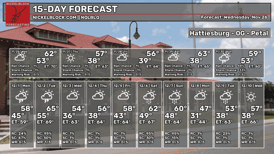
And with that, I mean the average temperature will be lower for a while. A large high pressure system has moved in from Canada introducing overall cooler temperatures to the region. We’ll get some of the northern winds for the next few days, so expect cool and dry conditions for your Thanksgiving and Black Friday. As we roll into Saturday and Sunday, it’ll feel a bit milder as a cold front moves in with some rain.

We’ll start today off with a mild morning, but temperatures won’t stray too far off, only reaching the mid 60s in most of the area. Winds will be gusting from the north indicating the cold front’s passage. Temperatures will fall into the upper 30s tonight with clear skies. Thanksgiving will be another sunny day with temperatures in the upper 50s. It won’t quite be sweater weather for most, but you can go outside and throw the football and come in for lunch/dinner without a drastic change. Temperatures will fall close to the freezing mark overnight.
Black Friday will be another cool day with highs in the mid 50s during the day and increasing clouds. Overnight, we’ll fall into the low 30s again. Saturday we’ll have milder conditions as winds shift towards the southeast. Highs in the low 60s. As we move on towards the evening, rain chances will increase after midnight into the early morning. A few thunderstorms are possible, but this looks to be mainly a rain event.
As the cold front moves in, rain chances will become more scattered overall as the line begins to fall apart. Expect a rainy day on Sunday, so if you’re going to church or going shopping, bring a jacket and umbrella with you. Temperatures will reach the mid 60s during the day and low 40s that night. The GFS and European models still differ on the timing of the next round of rain next week with a Gulf front moving in bringing heavier rain. The GFS says Monday, whereas the Euro is placing it around Tuesday. I’ll have an update on Friday.