Boy oh boy! It wouldn’t be a Gulf Coast forecast without some storms, right? Well, given the new data I’d argue that the risk for storms across more of the area is increasing and the risk for widespread snow/ice/sleet/freezing rain is decreasing.
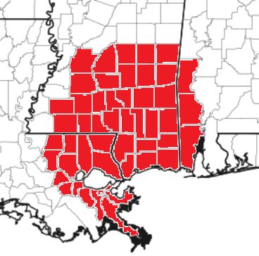
And since I know some are new here, the counties in red is the area we try to “cover” with regional forecasts like this one:
So what is the forecast? I’m so glad you asked!
The timeline for precip, generally, looks like this:
Saturday midday: Rain starts, temperatures above freezing (by a good bit)
Saturday night: Off and on rain showers and storms, still above freezing across a majority of the area. Up north of I-20 and back west into northern Louisiana, we may dip below freezing for an hour or two. Down south (south of HWY 84), storms will be possible and south of HWY 98, temperatures may be warm enough to support surface-based severe weather
Sunday morning: Hit and miss rain showers and storms will be possible with a very wide temperature gradient across the area. Some folks in the mid 30s others near 70. Nearly all precip will be falling as liquid, only places well to the NW of Jackson, MS will see anything freezing on the surface
Sunday afternoon: Colder than the morning for most spots. Between the advancing cold front and the falling rain, most places will peak with their high temp around 9am. Rain and storms will be possible across the whole area, with surface-based storms (severe potential) mainly near and south of HWY 98 now).
Sunday night: Rain moves out and any lingering precip behind the front will fall as sleet or freezing rain. May even see a few ice crystal flurries. Accumulations will be highest northwest of a line from Lafayette, LA to Brookhaven, MS to Meridian, MS. But accumulating freezing rain and sleet should remain below 0.25″ in total.
I know that is a lot of words, I know, so let’s take a look at some charts!
VISUAL TIMELINES
All of that above distilled into a quick precipitation-type chart looks like this:
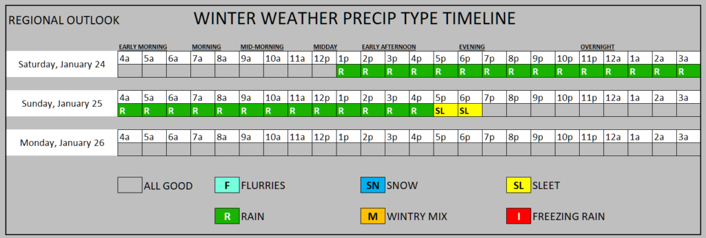
I want to stress here, the specific timing for these things is going to be different depending on your specific location. But “Generally” this is how things should shake out. I suppose I could’ve added a “flurry” on there at 7p on Sunday, but any flurry will be an ice crystal flurry and not a snow flurry, so it’ll be tough to see.
For folks worried about severe weather, I think we have two windows for anything surface-based… around 4a or 5a and then again around mid-morning as the cold front swings through.
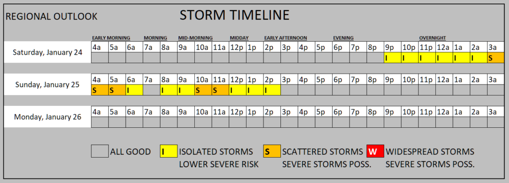
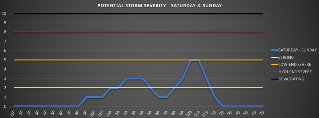
But the potency of the severe weather won’t be terribly potent. On a 1 to 10 scale, where 10 is the worst of the worst, we only tag the “low-end severe” mark. So, heavy rain, lightning, the risk for some hail and gusty wind, and we can’t rule out a brief tornado.
I think the risk is higher mid-morning than it is pre-dawn, but even that is “TBD” at this point.
I want to end here with road conditions because this is the biggest “impacter” to most everyone. Roads should be mostly just wet through Sunday evening.
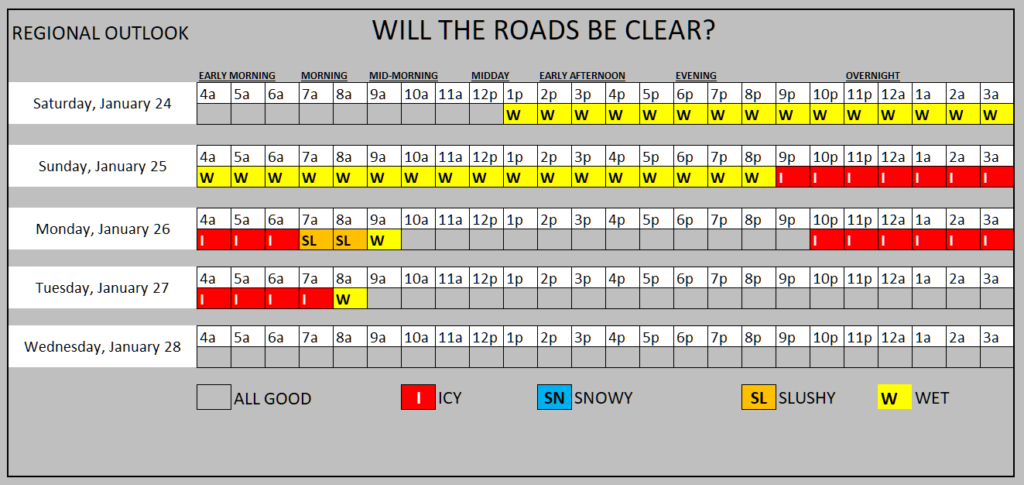
The question marks for Sunday include….
— How cast does the precip exit after we change-over and the temperature falls below freezing
— How fast does the temperature drop behind the front
— How dry is the air behind the front
The different combinations of the answers to those questions will dictate how icy the roads are for the rest of Sunday night and into Monday morning. And also how icy the roads are Monday night and into Tuesday morning.
If we change-over quickly behind the rain to a mix of sleet and freezing rain, and the cold air comes barreling in, and it is a “humid” batch of cold air, then we could be talking about a quick freeze of all liquid anything outside. That means roads, sidewalks, and trees would all freeze-up during just a short few hours.
With the risk of freezing things up and the wind that will be coming in, we also have to worry about power outages. And while there will be some outages related to rain, wind and the few storms that will be out there on Sunday morning, I think the bigger chance for outages comes Sunday night and into Monday morning.
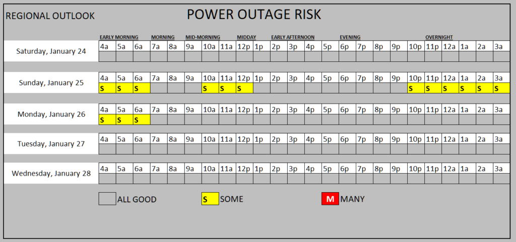
This is, again, a regional view. So some folks won’t have to worry about outages at all. But there may be some in teh area that last for a few hours. Especially given the winds. The guys int eh bucket trucks can’t go up there if it is too windy. So if you lose power and the wind continues, you can’t get power restored until it calms down enough for the linesmen to work.
BOTTOM LINE
A lot of this can still change. This isn’t set in stone by any means. But we are finally getting to a point where I feel confident enough in the data that I can start to give a “big picture” look at the timing across the region. I think it’ll be another 24 hours before I can go county-by-county with this.
But the take home points are these….
— Rain will be the primary precipitation type for a vast majority of the area for a vast majority of the time
— A brief changeover Sunday afternoon / evening to a mixture of sleet and freezing rain for nearly everyone but it will be very brief
— Impacts to the roads will likely be dictated by how fast the cold air comes rushing in to freeze the liquid that has already fallen… and less so about the accumulation of wintry precip
— The wind may be quite gusty Sunday, nearly all day, but especially in the evening behind the front
— Icy roads (black ice) Monday morning are almost a guarantee from this kind of set up
— Dangerous wind chills Monday morning with temperatures in the 20s and wind chills in the teens
Hang in there, we will continue to know more as more data comes down from the weather models!


Thanks for the info.
Always look to you for “real” weather updates.
My first time on this App. Appreciate a more detailed weather forecast than is usually published-especially road conditions. Thank you Nick. Miss you.
I trust you over any of the other meteorologists. I appreciate the way you break it down for us. Thank you. Miss you. channel 7